

whoosh
-
Posts
43 -
Joined
-
Last visited
Content Type
Profiles
Blogs
Forums
American Weather
Media Demo
Store
Gallery
Posts posted by whoosh
-
-
5 hours ago, RCNYILWX said:
If consistency continues on this scenario, we in the NWS are really gonna have to hit the message hard about this being a life threatening blizzard, with incredibly cold temps for a system of this nature. Barring a big change in the evolution, the probability is increasingly high for the main swath to see extreme impacts. That's despite it being mainly a Thursday PM-Friday event.
which with all appreciation and gratitude I as a close NWS/LOT watcher, was yesterday delighted to see the office publish a Story tab about this event, and noted that it was removed today. .... though checking at this moment before posting I see that it has returned. Short of that lapse, LOT has had excellent messaging about this. Thank you all.
At the same time, I have close friends who just don't monitor weather at all; they just deal with whatever happens; it gives them stories to tell.-
 2
2
-
 1
1
-
-
1 hour ago, ChiTownSnow said:
Question.. given that it is around the holidays, when do you think winter storm watches would be hoisted? I would assume giving the situation, a bit earlier than normal?
There has already been messaging. Hoisting has a specific protocol.
-
On 10/19/2018 at 11:11 PM, jaxjagman said:
Not sure who has CrankyWX site bookmarked, but i'd for sure do this one.You most certainly could delete a few you already have.
I'll take this opportunity to aver how much I appreciated this voice in the community. It was sad to see him drop out. A quick search for him just now, long after his departure, reveals that the domain has expired (and been grabbed by a domain grabber). I know he was controversial; but I learned quite a lot from him, and still miss him. (hence the search).
-
1
-
-
-
3 hours ago, Hoosier said:
For the LOT cwa, at this point I think there's enough confidence to start talking up a sig-major storm/impact in the area, while expressing the uncertainty that remains particularly farther north in the cwa.
They have been.
-
1
-
-
As a lower Lake Michigan denizen, looking at the winds and waters the next couple of days, wondering if others are thinking or talking about the seiche potential.
@RCNYILWX here .... Skilling elsewhere .... others?
I documented and rough analyzed some seiche data from 2004 <https://tgeo.com/seiche_4521/> .... of course the public data sites have changed since then.
Here's what monitoring potential I have for now:- https://tidesandcurrents.noaa.gov/ofs/lmhofs/lmhofs.html
- https://www.weather.gov/greatlakes/ wind/waves only (double click for forecast point)
- https://www.weather.gov/lot/marine
- https://www.lre.usace.army.mil/Missions/Great-Lakes-Information/
-
1 hour ago, TheNiño said:
My view of Lake Michigan looking toward Chicago from Racine. This is way more impressive in person. Really incredible. So primed!
That's nice! .... Down here in the band it's way breezier than it looks up there.
-
4 hours ago, CheeselandSkies said:
...aaaaaand were STILL looking at lows in the single digits through the end of next week.

Yeah. Since snowpack and cold temps are mutually reinforcing, the next several weeks will be yearning for sunshine.
-
1 hour ago, RCNYILWX said:
Glad the forecast is working out pretty well for most of the area.
Worked out fine up here in N.Cook I've been shoveling every couple hours. Drier than I was anticipating/(fearing?). Windy. No viable measurements available. Forecast details aren't as important as the well presented lead-time "heads-up" messaging which also well stated the uncertainties.
-
2 minutes ago, Owensnow said:
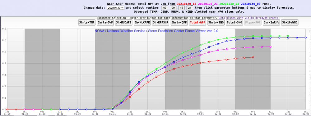
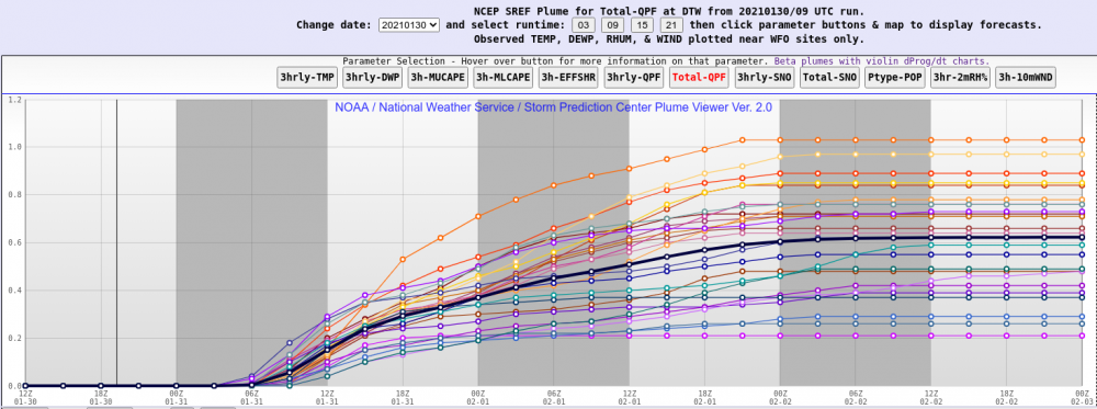
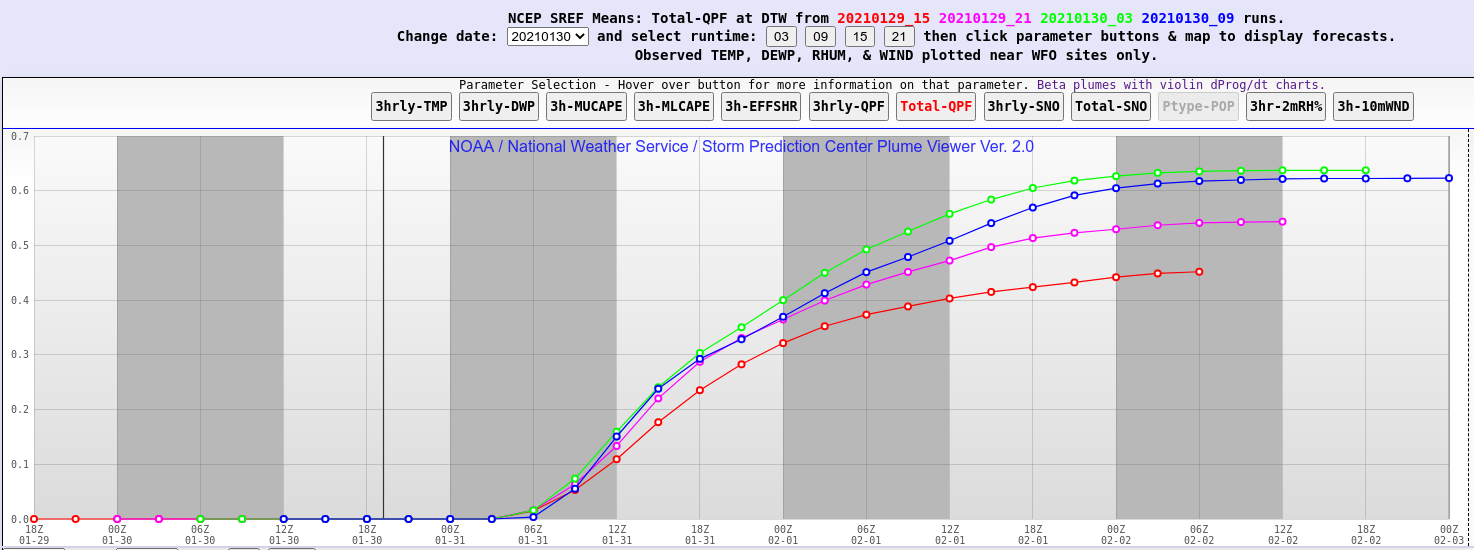
Anyone have the 15z plume qpf means for DTW yet?
-
To the discussion on radar sites, I get a lot of mileage out of https://www.aviationweather.gov/gfa , COD and MRMS already mentioned; also weathernerds.org for site based.
And of course wX on Android (for the Mosaic, set AWC images in the UI settings) -
1 minute ago, RCNYILWX said:
Enjoy the tracking today and I'll be up to enjoy the ++SN this evening!
Very appreciative of all your contributions, Rick, here and from the office. I'll be resting the day in prep for some long hours shoveling the wet stuff until I exhaust the beer and energy supplies, targeting midnight. It's been a few years since I've partied this hard. Drier event would be welcome tradeoff for higher totals. Will monitor obs for trends.
-
1
-
-
14 hours ago, Hoosier said:
I just realized that maps is spam spelled backwards.
Mail Abuse Prevention System (MAPS) was one of the first organizations to provide anti-spam support by maintaining a DNSBL. They provided five blocklists, categorizing why an address or an IP black is listed. MAPS was acquired by Trend Micro, Inc. in June 2005.

Pre-Christmas (Dec 21-23rd) Winter Storm
in Lakes/Ohio Valley
Posted
NWS explains it all ..... you can tell them this truth, and take the heat off you.