

Aallen
-
Posts
39 -
Joined
-
Last visited
Content Type
Profiles
Blogs
Forums
American Weather
Media Demo
Store
Gallery
Posts posted by Aallen
-
-
4 minutes ago, SchaumburgStormer said:
Apparently this snow photo is from Australia
Lol. I don’t know why it posted upside down. Anyway. It was a record snowfall for the date for us at 3 inches. And tonight’s predicted low of 7 would be the earliest we’ve ever hit single digits!
-
-
Supposed to drop to 7 here in Farmersville Ohio tonight. Previous record for this date is 15. That on top of record snowfall for the date of 3.5.
-
34 minutes ago, dilly84 said:
Euro still thumps.
What is euro showing for Dayton Ohio?
-
Gfs is holding true!
-
Cincinnati (Hamilton,clermont counties)just added to the winter Storm Warning,they were just wwa. Calling for 3 to 5 there with some ice
-
 2
2
-
-
awful quiet in here. Any thoughts or predictions?
-
Can someone post a snowfall map for ukie when it comes in. I haven’t been able to find one
-
1
-
-
14 minutes ago, dilly84 said:
The hrdps is going to crush Cincinnati north to Youngstown. So much for that rgem low track
I’m kinda new to this. How reliable is that model?
-
Just now, snowlover2 said:
0z NAM has a low traveling through TN and rain up to I-70. Just don't buy the rain/snow line that far north with that low position.
Especially since it has the freezing line at the Ohio river
-
Nam looks to be coming in a good bit south
-
Anyone think the 0z models shift south and put I 70 in bullseye?
-
What did the 12 z ukie show? I work nights and missed it
-
5 minutes ago, vespasian70 said:
I think we have the general track, now it's up to how the models handle the thermals. One false move and we will be in a bad ice storm. Fingers crossed.
I think for us,anyone within 30 miles either way of I70 are safe form any ice. Fingers crossed
-
I’ll take the ukie!!!!
-
Just now, buckeye said:
Agree...i'm running through these maps drooling over the low tracks and yet we're struggling precip issues. The gfs is the most confounding. This isn't back in december, when we had great tracks but no cold air. We have plenty of cold, both antecedent and fresh coming in..
 I
I
I agree. I think even if the track stays the same the snow line will be closer to the Ohio River
-
The gem came in further south!
-
Just now, vespasian70 said:
I'm not really looking at the precip types yet. Just watching the trends of where the low is going.
One would think with all the cold pressing in it would undercut the waa. Pushing the snow line almost to the Ohio river?
-
Looks like most of us gets at least 6 according to the nam
-
2 minutes ago, Hoosier said:
The isobars overall are placed a bit northwest. It's better to look at that than where the model is placing the H.
I see what you’re saying. New to this model watching, just love big winter storms
-
Looks like the high pressure may be pushing in quicker on the 0z nam
-
If I’m not mistaken wasn’t the fv3 best model on the last storm?
-
Just now, Jim Martin said:
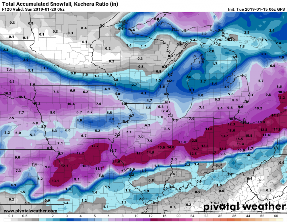
06z GFS not missing a beat. This is along with 20-30 MPH sustained winds too.
Looks to have shifted 20 miles south
-
Just now, vespasian70 said:
Gives you nearly a foot. But, it's a ways out. The models will bounce this all around over the next couple of days and settle down Thursday/Friday.
Fingers crossed!! Thanks


“Let’s Talk Winter!
in Lakes/Ohio Valley
Posted
Christmas Day is starting to look interesting!