

a.salt
-
Posts
76 -
Joined
-
Last visited
Content Type
Profiles
Blogs
Forums
American Weather
Media Demo
Store
Gallery
Posts posted by a.salt
-
-
Sleet in Millers...6.5 inches before switchover
-
 1
1
-
-
6 inches in Millers with heavy snow.
-
Just now, PhineasC said:
Enjoy it man. Might top 20 inches this winter if it all works out for you.
I hope!
-
2
-
-
Just now, PhineasC said:
LOL
Go shovel.
I will, because I have snow!
-
 2
2
-
-
1 minute ago, PhineasC said:
But, but, but, the NAM said 50 inches of CCB snows for Camp David! They were gonna get pummeled!
lol just chill dude and enjoy the ride. You lose and others win. No big deal. Called life.
-
4
-
 1
1
-
-
1 minute ago, H2O said:
Thats because the orange arrow is warm air. When they draw it going over us its too far. We need that arrow to stop near VA Beach for us to get the cute puffy cloud
It's overtop me but I'm still inside the purple?
-
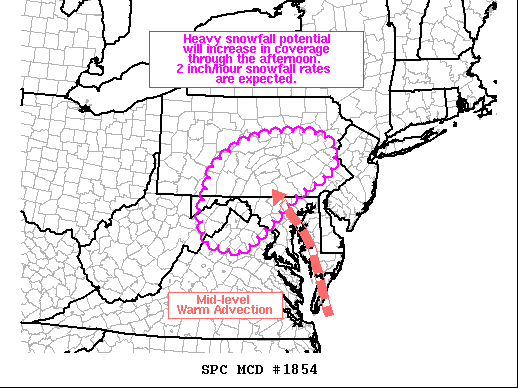
 Mesoscale Discussion 1854
   NWS Storm Prediction Center Norman OK
   1257 PM CST Wed Dec 16 2020

   Areas affected...Northeast West Virginia...northern
   Virginia...western Maryland...and central to eastern Pennsylvania

   Concerning...Heavy snow

   Valid 161857Z - 170000Z

   SUMMARY...Heavy snowfall rates around 2 inches per hour are expected
   to increase in coverage through the mid to late afternoon hours
   across portions of the Mid-Atlantic. Heavy snowfall will likely
   continue into the overnight hours for portions of
   eastern/northeastern Pennsylvania.

   DISCUSSION...Precipitation continues to gradually increase in
   coverage across much of the Mid-Atlantic region within a broad swath
   of strong warm air advection between 850-700 mb (per recent RAP
   soundings and mesoanalysis). Mixed precipitation types continue to
   be reported within the precipitation transition zone along the
   Roanoke to Fredericksburg, VA line. While a wintry mix, including
   pockets of freezing rain, will continue in the near term, this zone
   should become more limited spatially through the mid/late afternoon
   hours. Further north, moderate, to at times heavy, snowfall rates
   have been observed (as evidenced by visibility reductions to
   one-quarter mile and observed snow rates around 2 inches per hour
   for some locations in northeast WV).

   Heading through the afternoon, the low that is currently advancing
   northward along the Carolina coast will continue to deepen. As this
   occurs, mid-level winds will strengthen and begin to tighten the
   850-700 mb baroclinic zone and augment warm advection across the
   region. As isentropic and frontogenetical lift increase, snowfall
   rates will see a corresponding uptick in intensity. Lift within the
   dentritic growth zone and weak instability closer to the coast will
   help further augment snowfall rates. Widespread snowfall rates above
   1 inch per hour over the region are likely, and the potential for
   widespread snowfall rates exceeding two inches per hour will
   increase through 00 UTC as the potential for organized
   frontogenetical/deformation-driven snow bands increases.
-
4
-
-
1.5 inches in Millers with heavy snow.
-
1
-
-
Roads covered here in Millers. Close to an inch so far.
-
1
-
-
31 degrees and light snow in Millers. Close to a dusting already.
-
30/18 in Millers
-
31.0 degrees here in Millers with snow still on the ground from yesterday. Should keep things cold overnight.
-
1
-
-
-
Snow is ending here...total of 1 and a half inches. Enough for kids to sled and have fun!
-
3
-
-
Maps?
-
Mostly snow now in Millers...temp is still 39.0 degrees. Big, heavy flakes coming down.
-
Snow mixing with rain in Millers...temp has actually risen to 39.0 degrees
-
1
-
-
38.8 degrees here in Millers, MD with sleet mixing in.
-
1
-
-
2 minutes ago, losetoa6 said:
Lots of heavy rain / wind and some lightning.
Up to 1.65"
Losetoa6 where in Carroll are you located?
-
About to get hit here in Manchester...Currently no warnings or wind to speak of
-
Flooding in Millers, MD. Tearing up Roller Road outside our house
http://cloud.tapatalk.com/s/5d1e481addc15/20190704_141710.mp4
Sent from my Moto E (4) using Tapatalk
-
1
-
-
From LWX (4:33 AM)
.SHORT TERM /FRIDAY THROUGH SATURDAY NIGHT/...
Low pressure will traverse the area Friday. It`s weak, but there`s
notable warm advection in the 850-700 hPa layer, tucked under a
modest coupled upper jet structure and mid-level PVA. Given the cold
temperatures, any precipitation that falls will be snow and have no
trouble sticking. East of the mountains, lift is focused in the
dendritic snow growth zone, so despite low-level dry air believe
there should be at least some steady light snow in the I-81 corridor
and near/north of US-50. Along and north of I-70, moisture and lift
are a bit better and this is where the best chance for plowable snow
exists east of the mountains.

As far as the ridges of the Allegheny Highlands go, lift here is
actually a bit below the dendritic snow growth zone. Cold
temperatures should yield ratios close to 18:1, but with low
inversion heights and less than ideal wind trajectories, current
most likely forecast is for sub-warning level snow (solid advisory,
3-6"). Therefore, have opted not to go with a watch at this time.
Advisories will likely be needed over the mountains and in northern
Maryland (especially given the cold ground and potential impact) for
Friday, if current forecast projections remain on course.

-
2
-
-
From LWX:
Here are the current rankings for wettest year on record
(through November 15th):
Baltimore MD area (BWI)
1. 63.01 inches (2018)
2. 62.66 inches (2003)
3. 62.35 inches (1889)
4. 58.98 inches (1979)

Weather records for the Baltimore MD area have been kept at
what is now Baltimore-Washington International Thurgood Marshall
Airport (BWI) since 1950. Precipitation records observed
downtown extend the period of record back to 1871.
Jan 31st - 33rd Storm Obs and Disco like it's 1979
in Mid Atlantic
Posted
Light snow has begun in Millers!