

RockerfellerSnow
-
Posts
53 -
Joined
-
Last visited
Content Type
Profiles
Blogs
Forums
American Weather
Media Demo
Store
Gallery
Posts posted by RockerfellerSnow
-
-
3 minutes ago, Ericjcrash said:
No. Looks to go too far North. LHV theres a slight chance.
You’ve been wrong, I’m betting that a thundersnow could hit the Times Square area!
If I lose I don’t post for 2 months this time.
If you want to make the high stakes... I think I’ll even bet that we get another one in a week or so. Similar maybe more snow but no rain this time. Heck this storm is colder than modeled for sure so therefore I would like to conclude that models are good but crappy at the same time. You have to solve the problem that the season makes sense.
-
Nicest storm I’ve seen in a while and probably ever in November. But the question is still will New York City get thundersnow tomorrow morning with the ccb?
-
2 inches in Central Park
-
Just now, Snow88 said:
Have you checked the models?
The mix line is going to stall
Heavy snow until7pmfor Central Park definitely 3-4 inch possibility here
-
 1
1
-
-
Moderate snow in Central Park now.
-
I’m going to say 4 inches for Central Park now. Raised the stakes
-
1
-
-
34 cloudy in Central Park
-
Just now, Brasiluvsnow said:
WOW already ? And you posted this an hour ago !!!!!!
It changed to a mixture of rain and snow but still over performed there
-
1
-
-
Looks like an over performer in the south let’s see what happens here the next 6-8 hrs
-
11 minutes ago, donsutherland1 said:
You may have misread his post. He wrote, "... 2” for the far Uws where I work (120th and Broadway)." That's not far from Central Park's Zoo, so it implies a measurable snowfall even there.
P.S. Given some past measurement debacles at the Park, it's an open question whether you will be the only one measuring. Last winter, there was one or two occasions that no measurements appeared to be made after the snow stopped falling and then had either melted or been washed away by the rain by the time it fell. Traffic camera footage showed a easily visible coating and such a coating is more than a trace.
I still think Central Park will record at least 2... where he is probably closer to 3
-
1 minute ago, LongBeachSurfFreak said:
They are much further west then us and away from the ocean. I remember an early season event in early December about 10 years ago where they snowed and we rained.
I still like a coating for the coast and 2” for the far Uws where I work (120th and Broadway)
Dude we’re colder and more north this isn’t a coating for Central Park mark my words. I’m in Central Park today and I will personally go and measure and show you guys
-
11 minutes ago, NycStormChaser said:
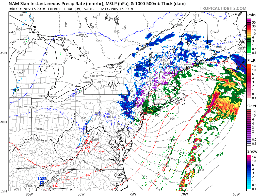
Forget the models at this point expect to see where zero hour matches up to current conditions. Nowcasting time.
DC is getting it good right now.
-
1 minute ago, SnowGoose69 said:
DCA is still snowing though most guidance had them raining.
Models usually underperform with dynamic cooling and evaporative cooling. Hopefully it doesn’t warm up too much today especially the fact that we got low clouds already. I’ll be back in 4-5 hours
-
Just now, Ericjcrash said:
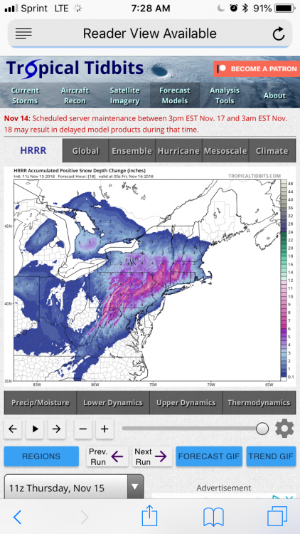
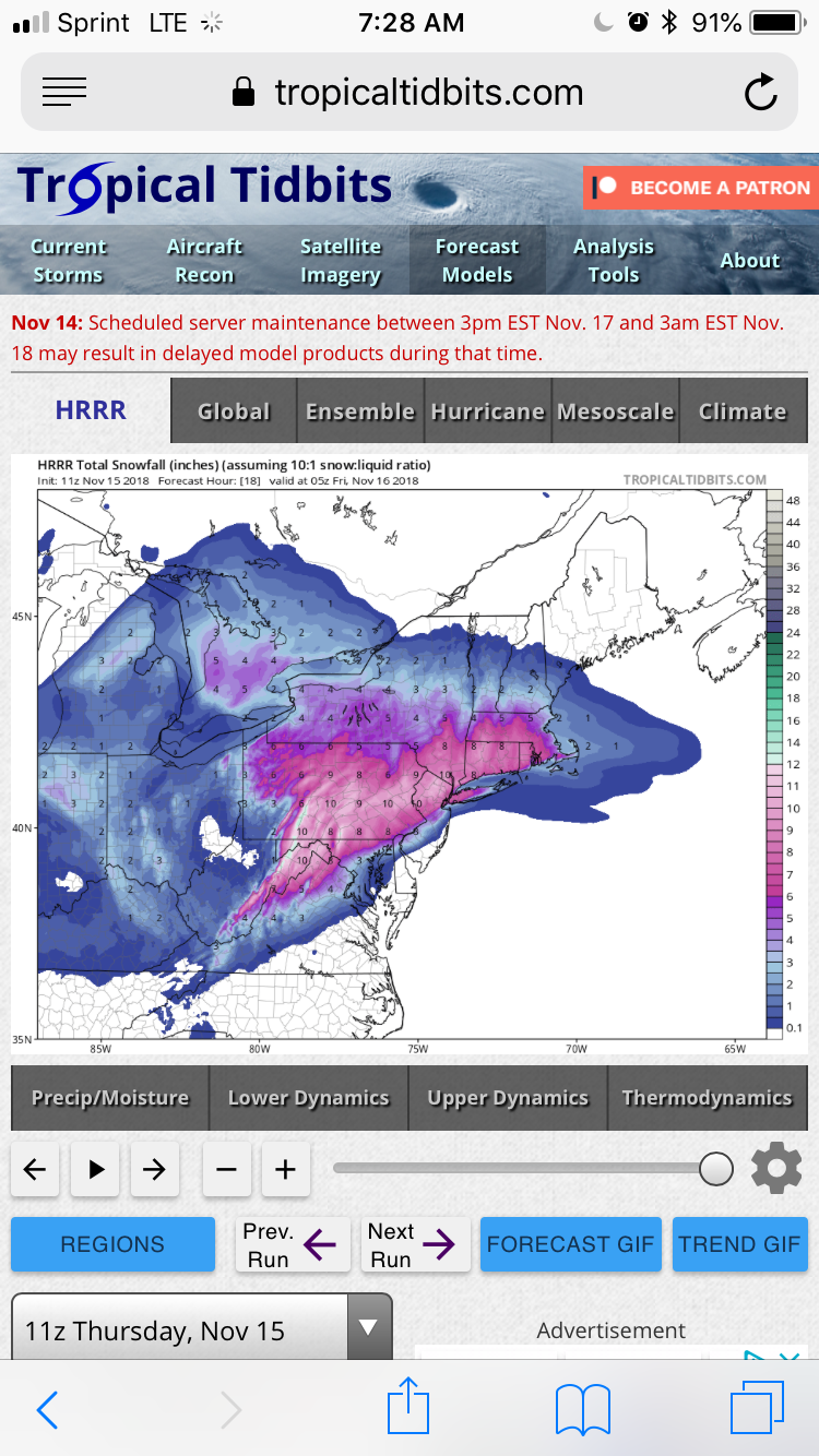
Dont be so sure. Its surely possible. HRRR has burned us all many times. Depth change maps of HRRR do show 2-3" though but thats overdone IMO depicts quite a bit of sleet.
Hrrr is the best model att
Hrrr has 6 hours of heavy wet snow for the city and 2 hours of frozen mix and than dry slot

-
51 minutes ago, Snow88 said:
0 for the city with a few inches inland
0 for the city? That’s not right we’ll get an inch for sure! Did u see the latest hrrr
-
10 minutes ago, Ericjcrash said:

Hrrr is very snowy for the city and in fact it’s snowy for everybody .
-
Billy’ is in ulster thats even a better spot what you think?
just hit 32 here new Rochelle for the first time this year. And of course we get our first freeze and first snow the same day.
-
Thundersnow

-
4 minutes ago, Ericjcrash said:
Emphasis on weenie. Gfs all out rainstorm. They will toss it now but in 3 weeks when it shows a crazy solution at 180 hours it will be paraded around like a triple crown winner.
Gfs always does this. It’s great with track and time but a lot of times it doesn’t record the dynamics of the system and it essentially fails in the precipitation types in winter months.
-
Thunder snow?
i think we wetbulb
wet bulb is when the precipitation hits the ground as a result of drying out atmosphere. It could turn a normally warmer airmass cool down abruptly. Another thing is we’re going to heavy straight heavy snow for 6 hours it looks like. And once we hit night the models may get iffy on seeing the cold air from nightfall. No sun definitely helps put it that way. Regardless I think we get a good thump of at least 2 but could go as high as 5-6 inches if things go best where most of the heavy precipitation falls as snow and we get a few light showers of either sleet or freezing drizzle. It could turn obviously into rain too but notice when nighttime hits on models we get a flash of chilled air, and as the low is intensifying resulting thunder snow!?

-
 1
1
-
-
3 minutes ago, Ericjcrash said:
12k snow depth map seems reasonable. Probably overdone for NYC and a little underdone in CT and NW jersey but generally solid.

I disagree this has a chance of never changing to rain. Sleet and freezing rain or drizzle while we dry slot than we get a second round with the ccb
-
1
-
-
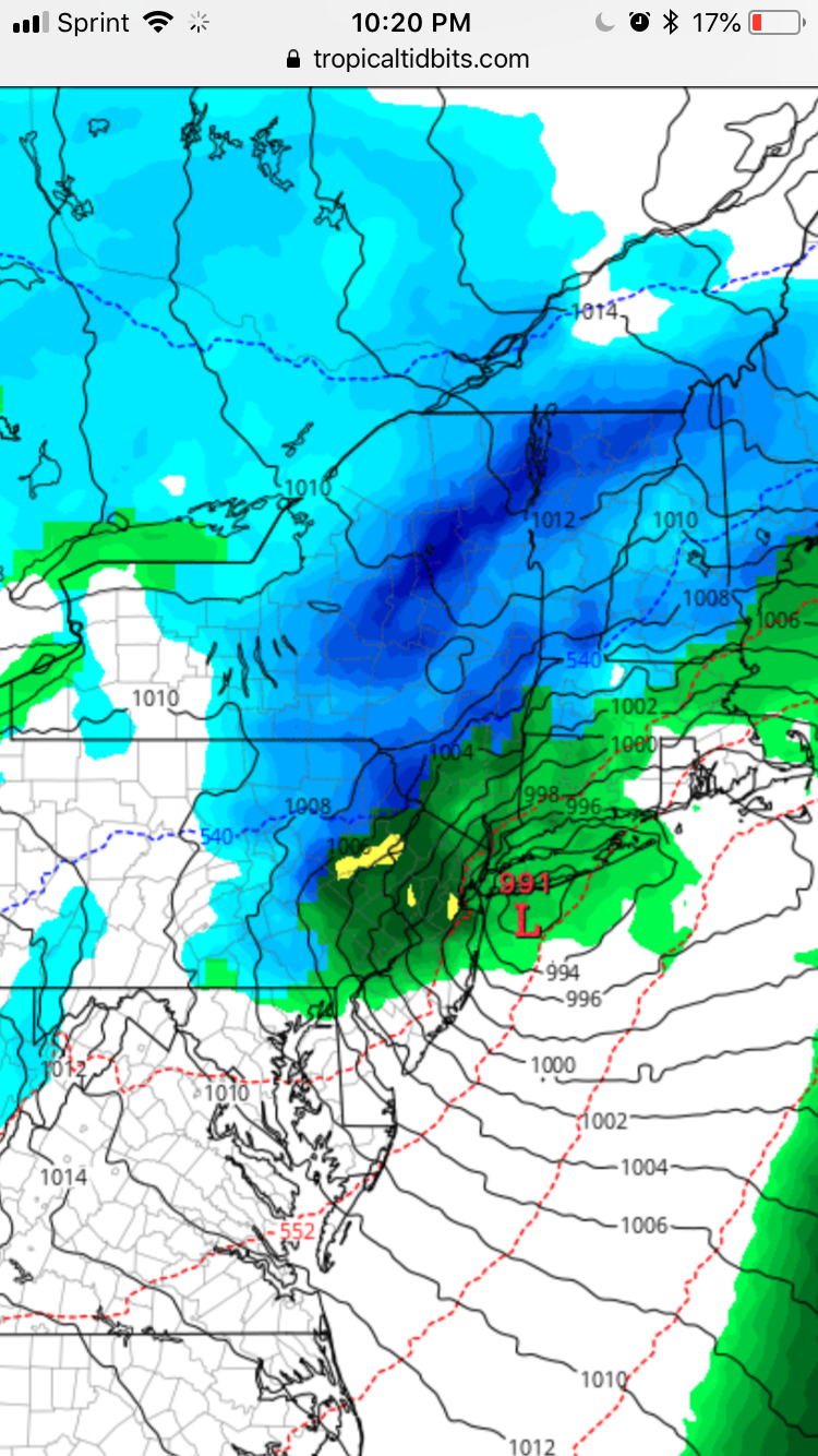
How was the euro 18z for Central Park sorry to bother u guys
-
1
-
-
1 minute ago, Brasiluvsnow said:
FYI I could be wrong but I believe you said an Inch and a half way back pages ago in your wager, IF IM wrong so be it but some guys in here are really nitpickers so I don't want you to have to disappear for a month over .50 or a half = just a weenie trying to help you out now back to our program
Bet is 1 1/2 but I think we get 2
-
2 minutes ago, Ericjcrash said:
It's not the wrong map. This shows what's on the ground. Not magically 10:1 sleet
That’s not how it’s measured. They measure several times before the storm finishes. I’m calling for 2 inches for Central Park. Heavy wet snow on a cold ground for 3 hours is at least 2 inches


11/15-11/16 Coastal Storm Observation Thread
in New York City Metro
Posted
Why are you still on here?