

Araqiel
-
Posts
41 -
Joined
-
Last visited
Content Type
Profiles
Blogs
Forums
American Weather
Media Demo
Store
Gallery
Posts posted by Araqiel
-
-
1 minute ago, frostfern said:
There's lots of rotation, but it's pretty broad. Higher values seem noisy and inconsistent, like birds or something. These things have a history of bringing damaging winds down to the surface when the RFD surges though.
What appears to be rotation is not within the storm - put a marker on that ‘couplet’ in any frame and you’ll see it’s way out in the inflow channel, not within the meso.
-
4 minutes ago, frostfern said:
It's an 850mb based cell. Hard to get a tornado out of that so far north of the warm front, but downbursts can certainly penetrate down into a stable surface layer. Also big hail still possible.
Also looks like sidelobe contaminated velocity data if compared with reflectivity.
-
8 hours ago, janetjanet998 said:
MOD rock still for overnight wind
AY 1 CONVECTIVE OUTLOOK
NWS STORM PREDICTION CENTER NORMAN OK
0737 PM CDT SUN MAY 26 2019
VALID 270100Z - 271200Z
...THERE IS A MODERATE RISK OF SEVERE THUNDERSTORMS THIS EVENING
ACROSS PARTS OF THE CENTRAL HIGH PLAINS...
...THERE IS A SLIGHT RISK OF SEVERE THUNDERSTORMS THIS EVENING
ACROSS PARTS OF THE MID ATLANTIC COAST REGION...
..SUMMARY
SEVERE THUNDERSTORMS WILL SPREAD ACROSS THE CENTRAL HIGH PLAINS THIS
EVENING, ACCOMPANIED BY A RISK FOR STRONG, POTENTIALLY DAMAGING WIND
GUSTS AND A FEW ADDITIONAL TORNADOES. ACTIVITY IS EXPECTED TO
GRADUALLY WEAKEN OVERNIGHT, BUT COULD STILL BE ACCOMPANIED BY A RISK
FOR SEVERE WIND GUSTS AS IT CONTINUES NORTHEASTWARD TOWARD THE
MIDDLE MISSOURI VALLEY.
..01Z OUTLOOK UPDATE
A CATEGORICAL MODERATE RISK FOR SEVERE THUNDERSTORMS WILL BE
MAINTAINED ACROSS THE CENTRAL HIGH PLAINS FOR THIS EVENING, BUT THIS
APPEARS INCREASINGLY LIKELY TO BE DRIVEN BY SEVERE WIND, SOME OF
WHICH PROBABLY WILL CONTINUE TO INCLUDE GUSTS IN EXCESS OF 65 KT.
SEVERE THUNDERSTORMS SPREADING OFF THE SOUTHERN ROCKIES APPEAR TO BE
CONTINUING TO GRADUALLY CONSOLIDATE INTO AN EVOLVING SQUALL WHILE
SPREADING INTO THE CENTRAL HIGH PLAINS. THIS HAS BEEN SUPPORTED BY
INFLOW OF AIR CHARACTERIZED BY AT LEAST MODERATELY LARGE CAPE, IN
THE PRESENCE OF STRONG DEEP LAYER SHEAR. CLOUD COVER HAS LIMITED
SURFACE HEATING AHEAD OF ACTIVITY ACROSS MUCH OF THE CENTRAL PLAINS,
BUT LOW-LEVEL MOISTENING ON STRENGTHENING SOUTHERLY LOW-LEVEL FLOW,
COUPLED WITH COOLING ALOFT ASSOCIATED WITH THE SHORT WAVE IMPULSE
NOW CROSSING THE ROCKIES, IS BEGINNING TO CONTRIBUTE TO INCREASING
DESTABILIZATION.
THE SQUALL LINE IS EMBEDDED WITHIN 40-50 KT SOUTH-SOUTHWESTERLY DEEP
LAYER AMBIENT MEAN FLOW, WITH STRONGEST MID-LEVEL HEIGHT FALLS
ASSOCIATED WITH THE SHORT WAVE FORECAST TO DEVELOP NORTHEASTWARD
ACROSS THE CENTRAL HIGH PLAINS INTO THE MIDDLE MISSOURI VALLEY
OVERNIGHT. WITHIN THIS REGIME, ACTIVITY IS EXPECTED TO OVERSPREAD
MUCH OF THE CENTRAL HIGH PLAINS THROUGH 03-05Z, ACCOMPANIED BY
INCREASING POTENTIAL FOR DAMAGING WIND GUSTS. MESOVORTICES EVOLVING
WITHIN THE SQUALL LINE MAY POSE A RISK FOR ADDITIONAL TORNADOES,
INCLUDING ALONG THE TRACK OF AN EVOLVING BROADER-SCALE LOWER/MID
TROPOSPHERIC CIRCULATION NEAR THE SQUALL LINE INTERSECTION WITH AN
OUTFLOW BOUNDARY ACROSS NORTHWESTERN KANSAS. AS THIS FEATURE
CONTINUES TOWARD THE MIDDLE MISSOURI VALLEY OVERNIGHT, IT MAY
PROVIDE THE PRIMARY FOCUS FOR ANY LINGERING SEVERE WIND/ISOLATED
TORNADO POTENTIAL.
ACROSS THE MID ATLANTIC COAST REGION, THUNDERSTORM DEVELOPMENT ALONG
A SOUTHWARD ADVANCING FRONT (NOW SOUTH OF THE PENNSYLVANIA BORDER),
AND AHEAD OF IT (SPREADING EAST OF THE CENTRAL APPALACHIANS), MAY
CONTINUE TO POSE A RISK FOR POTENTIALLY DAMAGING WIND GUSTS IN THE
PRESENCE OF MODEST LINGERING INSTABILITY AND 30-40 KT WESTERLY DEEP
LAYER AMBIENT MEAN FLOW.
"Moderate rock..." Nirvana fans know what comes next...

-
47 minutes ago, SluggerWx said:
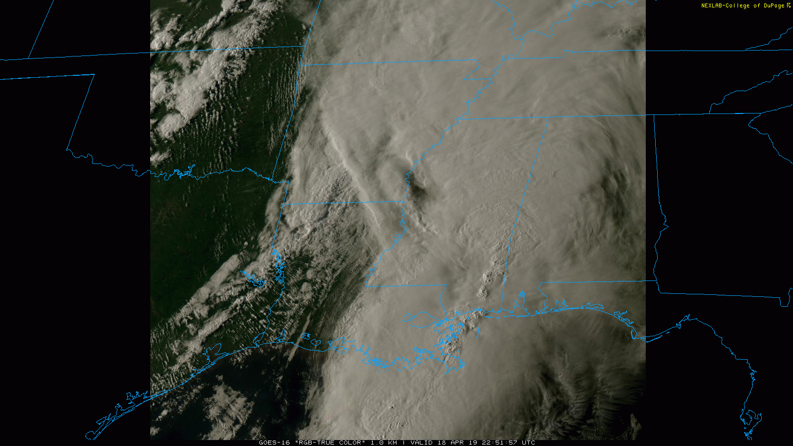
17z HRRR has a string of pearls across the TX panhandle by 5pm CST today.
https://www.pivotalweather.com/model.php?m=hrrr&p=refcmp_uh001h&rh=2019052316&fh=6&r=us_c&dpdt=&mc=
Sent from my Pixel XL using Tapatalk
Outflow boundary sagging across the panhandle could be a feature to watch.
-
Are things running a little faster than the HRRR suggests? Current radar looks more like the 12Z than the 10Z frame to me.

-
^That Hudson Bay vortex just will not die will it? Feels like it's been there more often than not for going on two years now.
-
Looks like they just upgraded to Moderate risk.
-
Some lovely gravity wave action over the TX Panhandle right now, meso sector is a joy.
-
Looking at a multi-hour radar mosaic loop its almost as if everything east of OKC took on a more eastward motion around 19:45Z.
-
Just now, Calderon said:
I've seen wording like that used from multiple offices, notably OUN and HUN.
First I've noticed it, with the talk of other offices leaving out the 'capable of' line maybe I'm just paying more attention to that.
-
On the Lenapah rotation warning:
* At 304 PM CDT, a severe thunderstorm with strong low level rotation
that could produce a tornado at any time was located 5 miles
northeast of Lenapah, moving northeast at 30 mph.
Unusual wording?
-
That PDS-warned storm looks a lot like a constructive interaction as the other storm approached from the south, more obvious on sat.
-
4 minutes ago, ct_yankee said:
That smaller cell up in Lenapah just produced a small tornado, watched it on live strem
Just saw that rotation pop up, near the northern end of the polygon too. Goes to show you have to respect the polygon.
-
That northern OK storm went full shitkicker mode at the drop of a hat.
-
One just north of Okmulgee is getting its act together now as well.
-
 1
1
-
-
1 minute ago, mob1 said:
Looks pretty good now, can probably use a TW.
Has one now, justified a few scans ago going by KINX radar.
-
47 minutes ago, BrandonC_TX said:
I only wish I could find the calibrated SREF that jojo762 speaks of.
You can find that here: https://www.spc.noaa.gov/exper/href/?model=href&product=guidance_tor_spchazcal_024h§or=conus&rd=20190430&rt=1200
This is the 24-hr calibrated tornado probs under SPC Guidance.
-
From the above-mentioned Twitter feed (also should have said 1630Z there):

-
 2
2
-
-
5 hours ago, PackGrad05 said:
Here is the definition for moderate from SPC. I'd say it fit the bill.
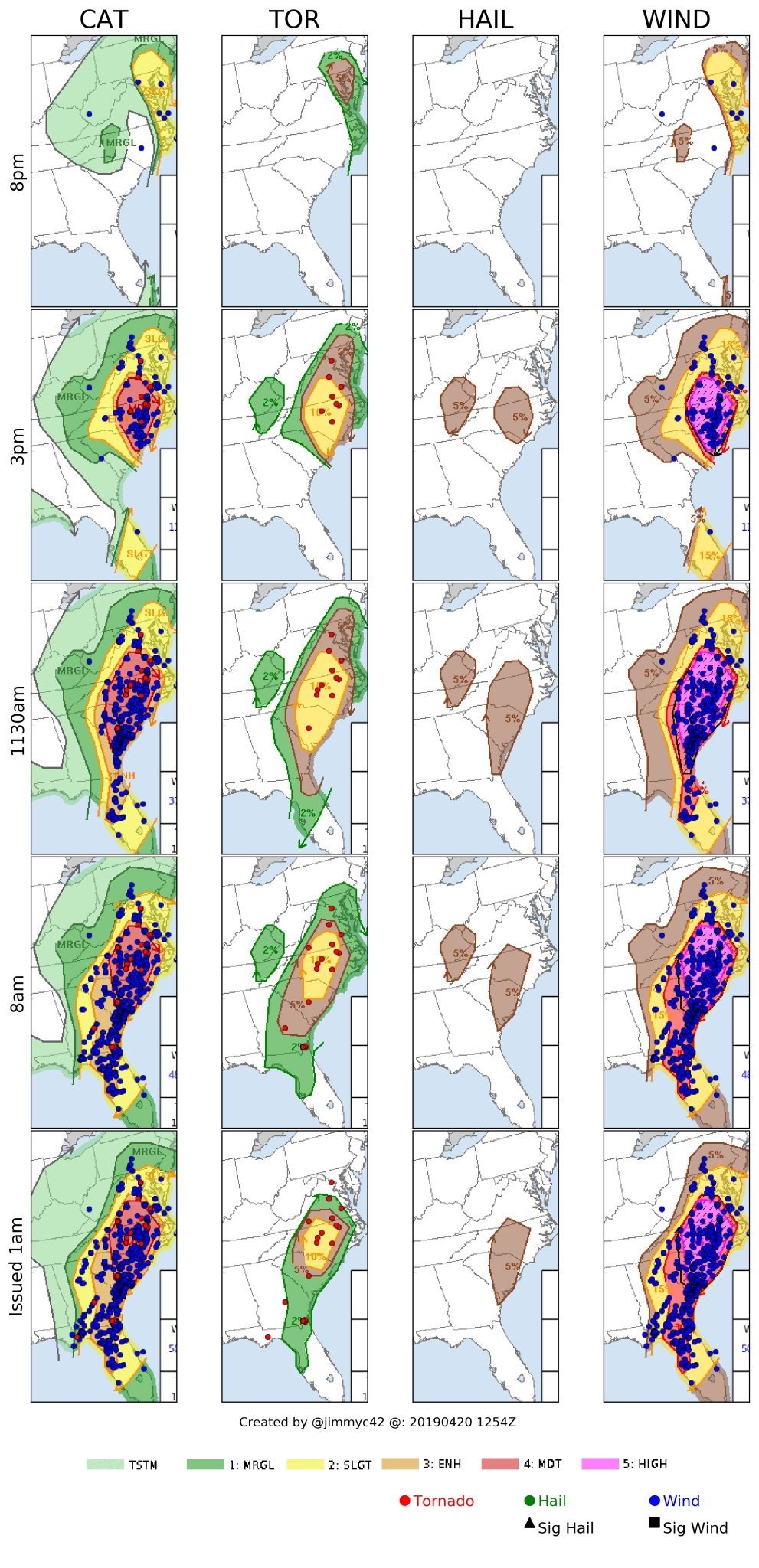
If you want post-event verification stats follow @jimmyc42 on Twitter. SPC categories are based on probabilities so you can't really just go by the description of the category. 17 tornadoes and 493 wind reports probably verified the 10/45% tor/wind probs nicely - they actually expanded the moderate at 2000Z which wouldn't have happened if they felt it was going off-track.
-
1
-
-
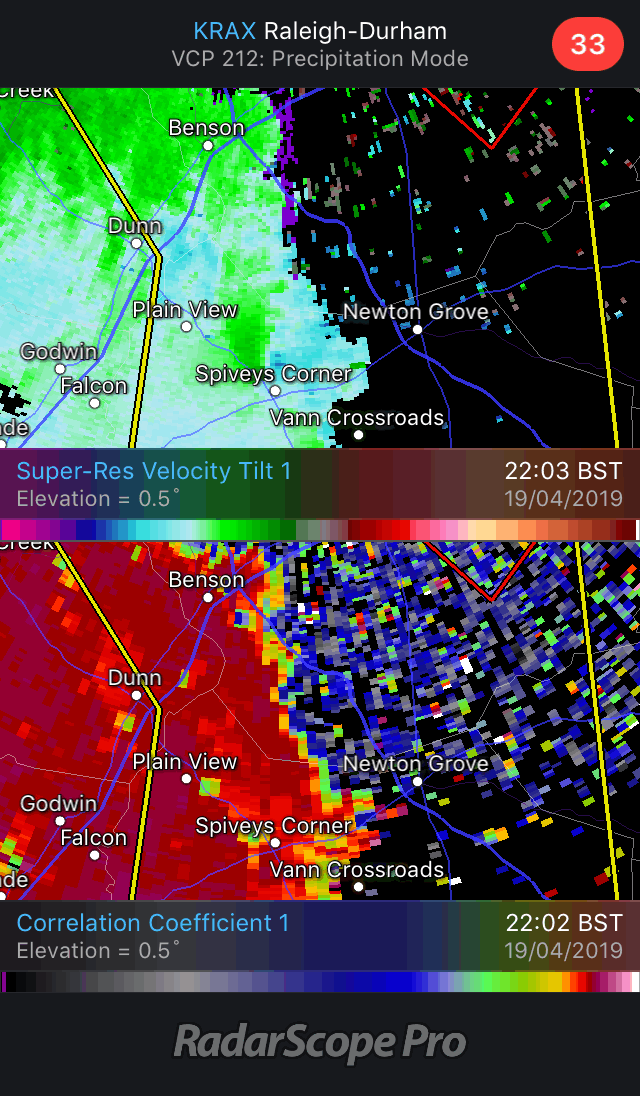
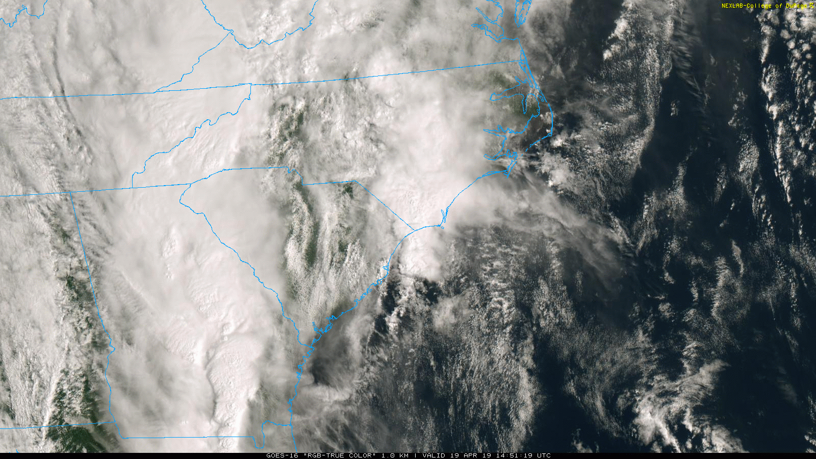
Isn’t there a couplet and TDS all the way from Spiveys Corner to the Smithfield warning polygon here? That started out as ‘a tornado was reported...’ but still radar-indicated too which seems odd.
-
The outflow boundary I mentioned earlier pushing ahead of the line over SC looks to be playing a part in getting these more discrete cells to develop as they cross into SE NC. Loop is 38MB for those on data.
-
Couple of decent outflow boundaries over SC that have pushed ahead of the line; looks like there's a small east-west OFB from the sub-severe convection over eastern NC just north of the central-southern NC/SC border as well.

-
3 hours ago, JMT417 said:
Can someone please explain how this is even possible? I know there is likely a reasonable explanation, but I don't know what it is.
That must be an error I'd have thought; you can get some odd polygons on CWA boundaries (that explains the top-right corner on this one) but this doesn't even fit a county outline.
-


Severe Weather 4-4-23 and 4-5-23
in Lakes/Ohio Valley
Posted
Yep, cold front overtaking dryline. KICT has a great depiction of the two colliding.