

GreensboroWx
-
Posts
342 -
Joined
-
Last visited
Content Type
Profiles
Blogs
Forums
American Weather
Media Demo
Store
Gallery
Posts posted by GreensboroWx
-
-
1 hour ago, wncsnow said:
All guidance shows heavy rain this weekend and middle of next week. No sustained cold. Give me all the indices you want, the proof is in the pudding.
All of the indices are for 8-10 days AT A MINIMUM, not for this weekend or even next week. I think a month from now, most people will be singing a different tune!
-
 13
13
-
-
Few ice pellets and light rain right now...temp 32.4 with dew point in the 20s....9mi NW of GSO. I'm REALLY worried about quite a bit of ice accrual by tomorrow afternoon.
-
4
-
 1
1
-
-
14 minutes ago, magpiemaniac said:
Light freezing rain on top of 12” of snow and 30F in GSO.
I took a short drive in the truck and the roads are pretty bad. (Obviously.) Neighborhood streets are impassable for most vehicles and main roads are rough. Only one lane each direction on Friendly and still slick after plowing. High snow banks from the plows leading onto neighborhood streets.
Yeah, road are horrible. Took my Subaru Forester out for a couple of drives and most roads were barely passable. It's going to be bad for a couple of days, to say the least. Kids probably won't go to school all week, if I were to guess.
-
1
-
-
33 minutes ago, cmh90 said:
I’ll eat my own shoe if that happens!
Often, upper lows, which are cold aloft in nature, over perform and are not well handled by the models. See Lubbock, Tx..... I wouldn't discount the NAM 3K.
-
2
-
-
13" in Summerfield, NC, roughly 9mi NW of KGSO. Light freezing drizzle at the moment.
-
2
-
-
23 minutes ago, packfan98 said:
Do you think there will be any significant icing? Seems like some of the models are picking up on the potential just SE of the Triad between Charlotte and RDU. I'm in NW Randolph Co just south of Archdale and am hoping to stay snow/sleet and avoid an ice storm.
Unfortunately, I DO think there is going to be some major icing, later Sunday after the brunt of the snow is over....I'm thinking in a line from CLT to RDU for the most icing.
-
1
-
-
3 minutes ago, wake4est said:
22z hrrr

Yeah, the HRRR has been consistent showing strong CAD temps. Impressive, if correct, which I have not reason to doubt
-
2
-
-
I know the storm is just arriving here in NC, but I've been impressed by the global models picking up on this event 7+ days. I'm not sure I've ever seen this. I'm trying to figure out why this storm is so well progged but others not so much. I'm thinking it may have to do to the strength of the waves, but that's just a guess. I'm thinking the locations right along the snow/sleet border is going to hit the jackpot of 16+" total which is insane for this area. Just think, we are only in early Dec and the way it's looking, Jan/Feb are going to be cold with plenty of blocking. I'm really thinking this is going to be a blockbuster winter for much of our region, esp the northern mountains of NC....wax those skis!
-
13
-
 1
1
-
-
1 minute ago, ajr said:
WRAL snowfall map - seems bullish to me
https://i.imgur.com/7f2QjDw_d.jpg?maxwidth=640&shape=thumb&fidelity=medium
Based on what I have seen with the overnight runs, I think it might be a bit conservative.
-
3
-
-
Just now, NCSNOW said:
Nam has position of HP back over western Wisconsin and also slow with the LP. hence position of HP compared to 6z results in CAA being started latter. Also wake up guys, Raleigh want be getting dry slotted. The model only goes out to 84 and has been the slowest with start up time by 6 to 12 hours compared to other models.
Yes, great observation. 84 hrs only takes us to Sunday afternoon and this storm is going to persist through Monday morning, at least.
-
2
-
-
2 minutes ago, wncsnow said:
The nam is definitely on the drier side for the whole area, which seems odd considering it used to be the most amped up/heavy qpf.... It shows the front end thump being not much more than a nuisance
.thumb.png.d2603e18b975f542de90c5c2d8cbaac5.png)
Geez, check out the time on the map!! The NAM is slower and the bulk of the moisture is just really getting into the N parts of NC. What I'm saying is this is just the totals for the very beginning of the storm. Be patient! Yes, it's warmer aloft but we'll have to see what other model runs tell us.
-
2
-
2
-
-
1 minute ago, CaryWx said:
Do you still that track mid-MS to off ILM?
Yes, 850 low tracks from northern MS through AL, GA and off of ILM....pretty ideal for NC piedmont
-
1
-
-
Nice 1040 high on NAM is good for PLENTY of cold air.
-
1
-
-
Maybe a touch less QPF but I'm only seeing the maps through Monday at 12z....still have the upper low to go by on Monday
-
1
-
-
Yes, I saw a few flurries on my way in to work.
-
4 minutes ago, jburns said:
Raleigh NWS is basically forecasting a rain event here with some flakes for a few hours.
Weather Channel has 6-10"
Some models have snowmageddon.
So my forecast calls for significant WTF.
As you well know, the NWS is going to be very conservative. Read their AFD...that's actually about as aggressive as you'll see several hours out. Anyway, why even look at their point forecast, you'll always be disappointed. All indicators point to a significant winter weather event for the Triad.
-
6
-
1
-
-
8 hours ago, Orangeburgwx said:
Swing and a miss on the 9th Storm... Great Lakes low #next
I assume you said this in jest.....it's still 9 days away so it's anyone's guess at this point. All the models have been hinting at something during this time. Once we're inside a week, maybe then we can start to analyze the situation a little closer.
-
1
-
-
Everybody is arguing over wind speed which is silly. It's a BIG and POWERFUL storm and appears to be reorganizing a bit. The main threat is flooding/storm surge due to the extremely slow speed of the storm. Any winds over TS strength will be bad due to the soft moist soil. This is not going to be good and is going to be catastrophic in many ways.
-
6
-
4
-
-
36 minutes ago, NYCGreg said:
Yea, the eye is gone now. It's not DOA, but I don't believe it will be close to a major hurricane by the time it even reaches land.
And you are basing this on what?? The eye is just covered by overcast and I believe it's reorganizing. I'm not saying it's to going to jump to a cat 5 or even a 4 but it still has to traverse across the gulf stream and many models show it holding its own or even strengthen a bit.
-
2
-
1
-
-
One has to remember this is a BIG hurricane and whether or not it's a 2 or 3 or whatever, the flooding potential is going to be unreal. Thrown in hurricane force winds and you have a disaster. I certainly hope the stall scenario doesn't play out but it's looking more and more likely Florence is going to slow down significantly either and creep through NC/SC or just offshore. Either way, it's just not a good thing for millions of people in its path or in its radius, which include me.
-
2
-
1
-
-
The Euro run is a worse case scenario for the SE coast of NC down through SC....the duration of the winds/rains would be catastrophic.
-
I'm far from a "long range" forecaster but I enjoy looking at various indices and climate model solutions. I will say the CanSIPS and the CFS Weekly/Monthly runs from last night show a favorable turn to cold mid Feb and beyond. I also read there is a SSW event taking place or getting ready to. (I'll see it to believe it)
The indices referenced above also are trending in this direction. I still think a portion of the SE is in store for a winter storm or two before all is said and done. I also think it is USELESS to even analyze ANY global model's solution beyond 168 hrs (1 week)...this goes for warm or cold solutions.
-
5
-
2
-
-
Looks like we are going to have a lull in winter weather through the end of the month. I'm not saying we'll have a torch, but above normal temps are likely. This will be a 10-15 day reprieve from the crazy cold we have had. I DO think we'll get back to below normal after the 1st week in Feb through the end of next month. I'm fairly confident we'll have more winter storms to watch during that period, as well. This winter is FAR from over for the southeast....
-
14
-
 1
1
-
-
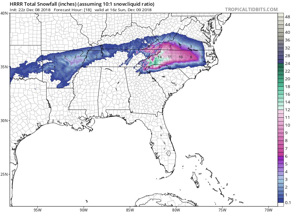
Latest HRR snowfall totals:

-
2
-
.png.4fac2db6eddfd5c893a3e97a08086824.png)
Mid to Long Term Discussion 2019
in Southeastern States
Posted
Yes, x 1000.
We actually have the cold or will next week. I think the southern stream will start to crank again in early Feb. I still believe we will still see a significant storm or two in the SE before all is said and done.