

SouthernVAwx
-
Posts
19 -
Joined
-
Last visited
Content Type
Profiles
Blogs
Forums
American Weather
Media Demo
Store
Gallery
Posts posted by SouthernVAwx
-
-
17 minutes ago, NCSNOW said:
I was just taking a peek on my phone to see. Away from house today. Dont have access to euro which is runing now. Maybe someone can chime in that does and give a 10 day update. Watch the 18z nam and short range canadian. Theyll be out around 400 ish today. Ive enjoyed tracking the sunday night monday deall on h5 vort maps. Knowing its highly unkikely for mby, but it really is so close. Still think northern coastal plain can score here. Well see. Biggest deal for certain is mtns ought th to rack up several inches with front tuesday night into wednesday. Im going 2 to 5 below 4000ft and 4-8 above 4000. When it want snow in your backyard, what you have to do is forecast for everyone elses and watch it on webcams lol.
Worth noting in the recent event in the northeast the short range models were all too far south and east and lost to globals. Now that the roles are reversed i don’t have much trust in any of the individual runs until their is consensus
-
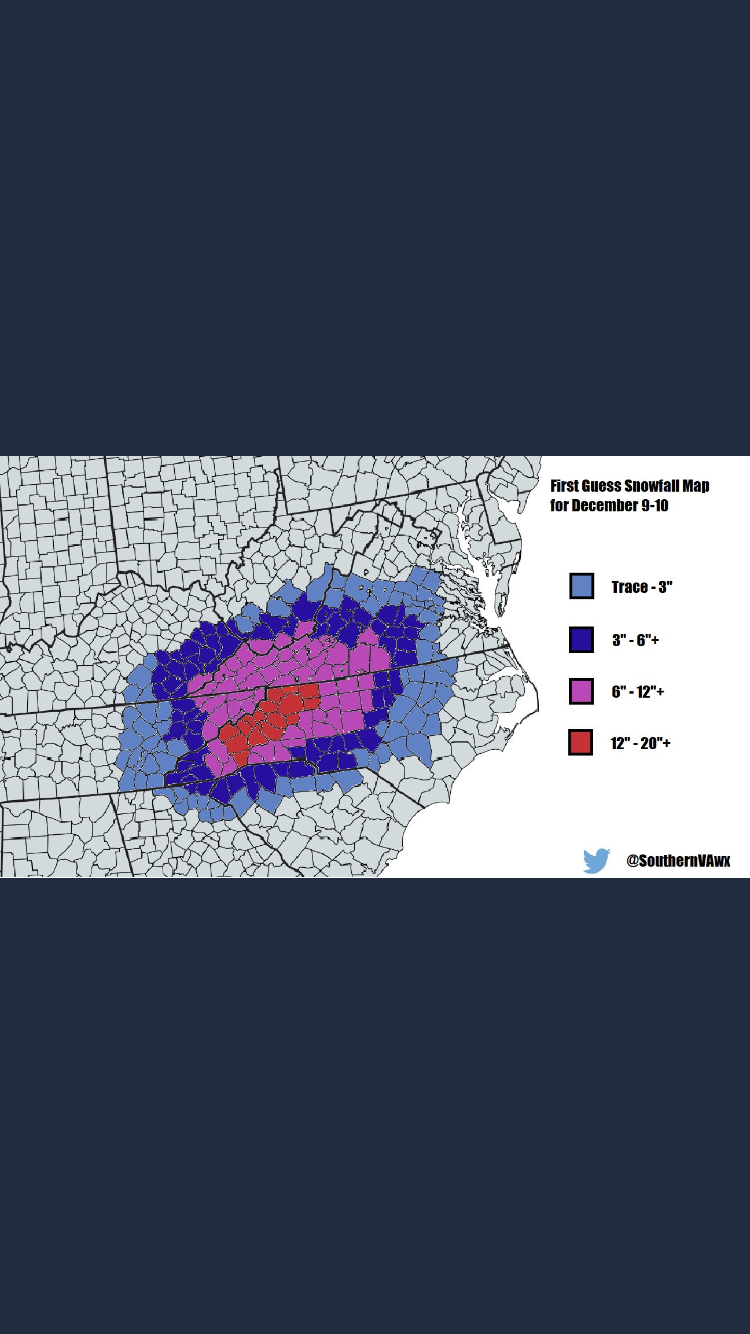
1 minute ago, wncsnow said:
Blacksburgs version

In my opinion a very good map. Has amounts that would have significant impacts with wiggle room to go up or down.
-
 1
1
-
-
Winter storm watches issued by RNK for a good chunk of their forecast area.
-
1
-
-
Here’s my first call map, take it for what it’s worth. Only a senior in high school so still learning the ropes so to speak, but really satisfied with this as a first call.

-
6
-
-
Canadian model doing its thing

-
 1
1
-
-
1 minute ago, WeatherHawk said:
Maybe I should rent our bedroom...I can offer IPAs and my wife's amazing shrimp and grits with cheddar and bacon
") Anyway...love the tracking here...it's all about the joy of the chase
Anyway...love the tracking here...it's all about the joy of the chase
I am willing to rent a bedroom here for the price of having to shovel our sidewalk, which stretches onto 2 bordering streets... Last time I had to my back was left feeling like a coal miners after years working in the caves.
-
Well ladies and gentlemen, after a brief successful revive, it appears the GFSFV3 has flatlined again. Please pray that the defibrillator works again and we can see this run out.
-
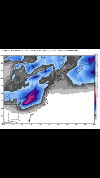
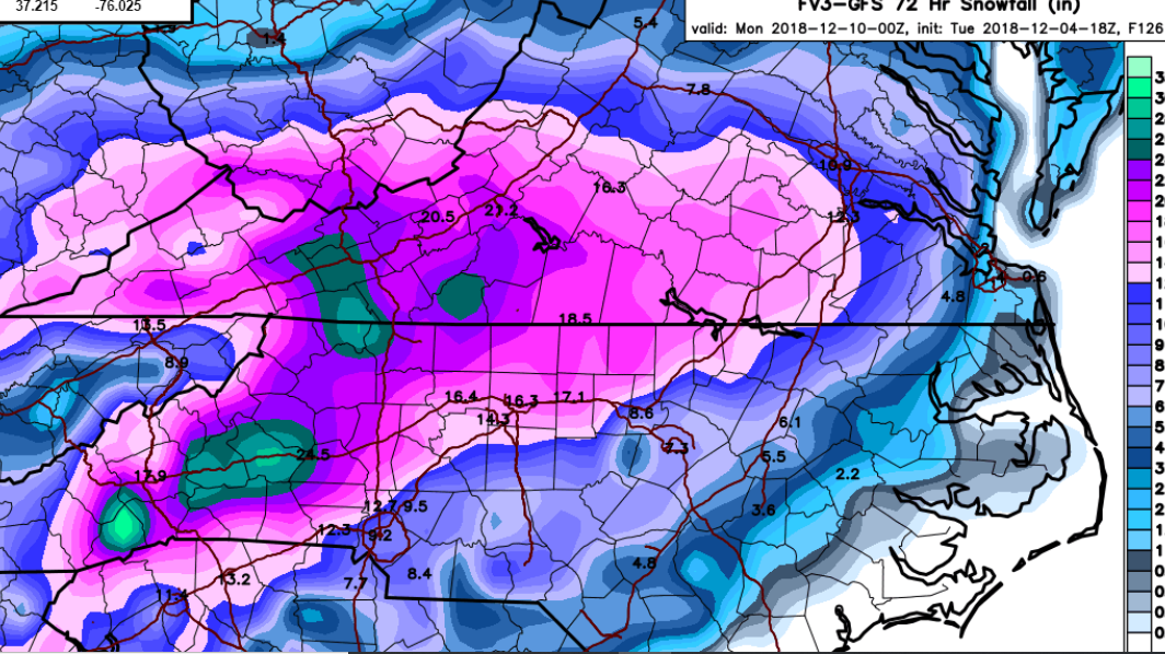
4 minutes ago, Poimen said:
FV 3 Kuchera through 0Z Mon.

Funny thing is that still doesn’t account for almost 24 hours of light snow afterwards.
-
Let’s have a moment of silence for the GFSFV3, it has failed to initialize after a very poor 12z load time.
-
 3
3
-
 1
1
-
1
-
-
2 minutes ago, Poimen said:
I'm not sure if this really matches the model, but I believe this is based on the Kuchera method, FWIW:
Pretty sure that is 10:1 ratio.
-
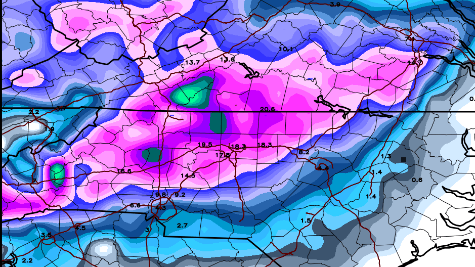
Despite the fact it’s slightly suspicious I like this run for my area! Snow 8 am Sunday to 8 pm monday with 16 inches kuchera ratio. Despite the fact it seems off interesting to note the coastal trend.
-
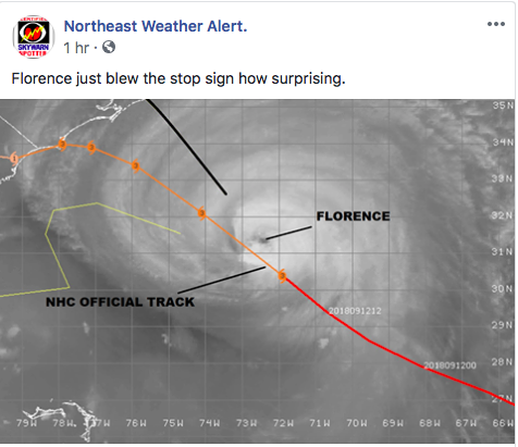
This is from Virginia Weather Network on Facebook.
-
Florence deciding to take a jump due north at the moment.
-
1
-
-
6 minutes ago, navvet8992 said:
It’s been doing this for hours today. Every track is updated slightly north and it still goes North. Because of this I’m thinking the SW curve is gonna start looking less and less impressive.
-
1
-
-
Have y’all noticed that Florence has been riding on the north side of things so far today? Was almost out of previous come of uncertainty earlier, and already starting to deviate north on the new cone. Storm has a mind of its own i swear.
-
Could anyone provide some insight as to what the big change was that resulted in most models not being able to bring the storm inland? I know steering currents will be weak if even present, but how would it move the storm south then in? Very weird modeled setup indeed.


Mid to Long Term Discussion 2019
in Southeastern States
Posted
Worth noting the 12z GFS builds on a severe threat for Sunday evening.