

Metsfan
-
Posts
853 -
Joined
-
Last visited
Content Type
Profiles
Blogs
Forums
American Weather
Media Demo
Store
Gallery
Posts posted by Metsfan
-
-
35 minutes ago, psv88 said:
It’s cold now, 34. But no precip now
The best dynamics are over the Hudson Valley, hence heavier precipitation, cooling the atm, thus snow.
-
 1
1
-
-
Nice rain squall currently coming through. Gusted to around 40. 47 five minutes ago now 38.
-
1
-
-
Went from 50 to 42 in five minutes. Down to 36 as of 915.
-
2
-
-
-
-
-
2 minutes ago, SleetStormNJ said:
He posts under MJO tag now.
OMG so sorry. I'm the real metsfan tho.
-
1
-
 3
3
-
 1
1
-
-
1 minute ago, weatherpruf said:
Yeah I see that. I just remember some picture posted here eons ago with some dude in a mets outfit, for some reason I thought it was Anthony.
Dude I think he is banned, but years ago.
-
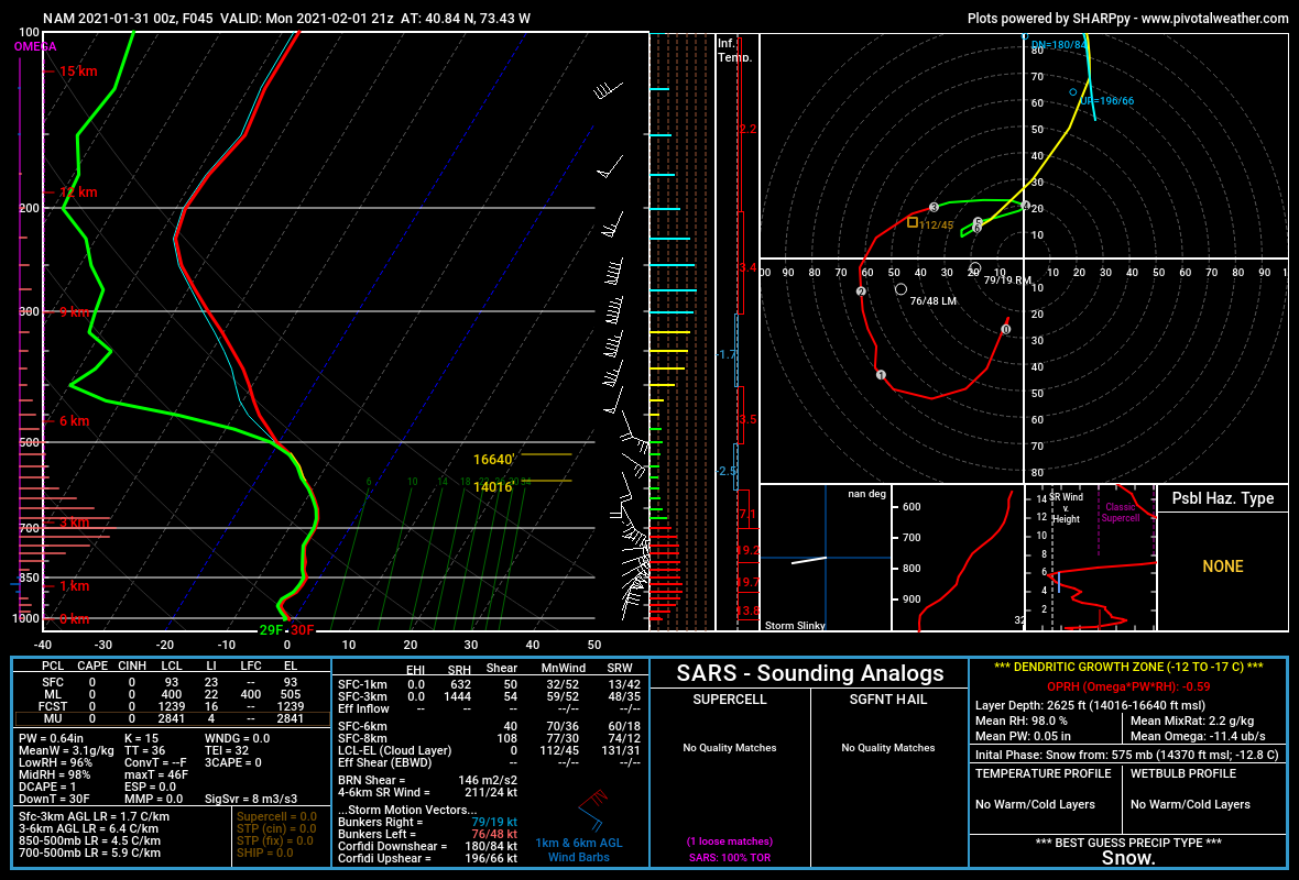
1 minute ago, jm1220 said:
PivotalWeather is pretty good. This is the sounding for my location at 21z Mon on the 0z NAM.

JM you are nw suffolk.
-
Just now, weatherpruf said:
Sorry for my ignorance, but I thought you and Anthony were the same guy...
Um lol no. I'm actually a met.
-
1
-
4
-
-
Looking for a good sounding website. I know psu has changed.
-
Everything looks good. East of route 112 is an issue.
-
2
-
-
1.5" mod snow. Wind marginal, but gusty. SPC mesoscale analysis is interesting. A lot of stuff pointing to east solution. 2 hour pressure change near kitty hawk with 850-700 frontogenesis north of the pressure change south and east of ACK.
-
2
-
-
2 minutes ago, weatherlogix said:
According to the Correlation Coefficient radar the mix line is racing north.....will that slow down or will this become a sleetfest on the south shore of LI in the next 3-4 hours?
Dude. Observe more post less.
-
4
-
-
-
I'm back! This event looks like a little snow to start before changeover. This system is a strung out mess.
-
3
-
May 2022
in New York City Metro
Posted
Marine layer ugh. Hate long Island this time of year.