

Weenie
-
Posts
38 -
Joined
-
Last visited
Content Type
Profiles
Blogs
Forums
American Weather
Media Demo
Store
Gallery
Posts posted by Weenie
-
-
Technically should be on the observation thread but the snow just started on Boston, pretty light as of right now
-
When will the peak of the storm hit the Boston area?
-
So I was away from the forum for a few hours, is cranky correct with the major shift east?
-
 3
3
-
-
1 minute ago, Hoth said:
This thing is already looking awesome on satellite.
Where can I find a loop?
-
1 minute ago, Hoth said:
This thing is already looking awesome on satellite.
Where can I find a loop?
-
Cranky is saying that the fact that the trof is sweeping and not digging and the fact that the low is racing ENE means that the Eastern guidance will win out. What does the forum think?
-
What's the pressure of the storm right now? And how is the phasing going?
-
3k NAM shows a major turn NW with the system once it clears cape cod
-
Trof is significantly more tilted this run, low is in same position albeit slightly deeper which has been the norm
-
2 minutes ago, JC-CT said:
I actually think the NAM will have a better phase this run.
It's definitely 2-3mb stronger and slightly farther west
-
 1
1
-
-
Just amateur observations but not only is the HRRR trending west by 50 or 60 miles every run, but the trof is digging down slightly further each time. Probably just noise though
-
I'm at that point where I'm getting excited for a new HRRR slide
-
Just a note, all the shortrange models have been trending west as the storm begins to form, even compared to the NAM
-
1
-
-
9 minutes ago, JBinStoughton said:
What is this ridiculous storm going to do? We're what, 36 hours out? Come on already lol.
At this rate we probably won't know what it does until the outer bands are lashing NE
-
These pressures are just ridiculously low. 963 mb is impressive, enough to throw precip almost as west as the previous run despite being much farther east
-
Just now, Typhoon Tip said:
Fwiw ..early on here this NAM run appears pretty identical... but were' only out to 12 hours
If there's even a 20 mile correction East half the forum will be on suicide watch
-
1
-
-
4 minutes ago, weathafella said:
You are so appropriately named...
Thanks, I've lurked on this forum for the Wednesday storm and I saw the word weenie being tossed around and I was shocked that no one had chosen it yet.
-
1
-
1
-
-
I've been pouring over HRRR runs for an hour and for every run the low jumps around dozens of miles like a hot potato.
-
I feel like this is one of those storms that has so many complicated interactions going on we won't know exactly where it's going until it's already formed and begun to phase
-
Hour 18 of GFS follows the same trends the other models have been following, several mb stronger when it hits the water. Might be slightly west but it's probably just noise
-
Worth noting that while RGEM is more Eastward it has a far more pronounced northern turn just like the NAM, and by hour 50 it's in a similar position to the 12z. Maybe this is a trend?
-
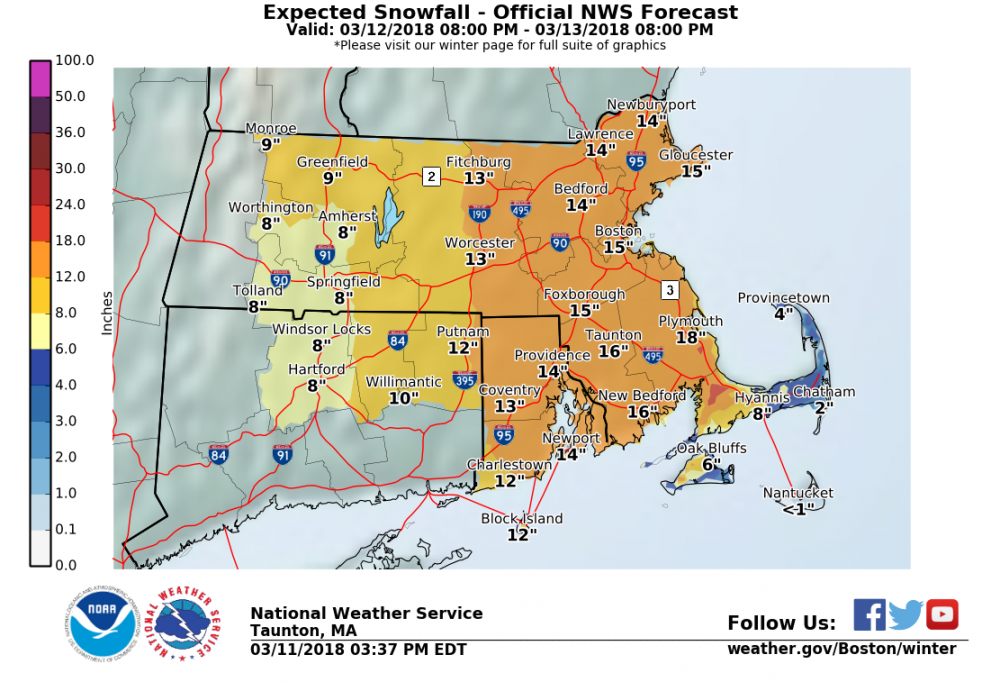
Major snowfall predicted by Taunton
-
1 minute ago, Typhoon Tip said:
Actually the N/stream is a tick west in the dive thru the Lakes, but similarly deep... that spatial orientation/relationship with the S/stream may play an eventual role there.
The S/stream is a couple DAM colder and deeper, also, about about a deg longitude further along... so the next spatial-relationship with the N/stream is cyclonic.. that "should" favor the phasing in total.
Yup, at hour 26 you can clearly see a difference in the northern stream. However the central vorticity is several dozen miles to the east so the stream might have a tougher time capturing the low.
-
Only 16 hours out but the NAM 12z been following the same trends as most models in the early stages, several mb deeper and slightly farther to the east

March 12/13/14 Blizzard/Winter Storm/WWA etc
in New England
Posted
Here in Arlington, in SE Middlesex county like 5 miles from Boston we've been getting pounded on and off since this morning. Last measurement I took a half hour ago was 14" and growing fast.