

Massplow
-
Posts
71 -
Joined
-
Last visited
Content Type
Profiles
Blogs
Forums
American Weather
Media Demo
Store
Gallery
Posts posted by Massplow
-
-
5 minutes ago, Damage In Tolland said:
Each run is creeping north. Should be a nice snowy morning at the very least
How far north is it reaching?
-
I know most aren’t interested in nuisance stuff but is Thursday night looking like anything for Eastern ma? I’m sick of this winter too but even a few inches takes some planning for snow removal operations so any chance interests me lol
-
 1
1
-
-
Just now, TalcottWx said:
Focus is definitely about to shift to eastern new england if it already hasn't.
You think?
-
7 minutes ago, 8611Blizz said:
That’s like what I was saying are these numbers still possible or are they just slowly letting people down/making the next shift deliver the bad news
-
All the tv Mets still have the Foxboro area in a 3-5 inch range are they just working their way down to nothing gradually to let people down slowly or is that still a possibility In that area?
-
1
-
-
2 minutes ago, JoeSnowBOS said:
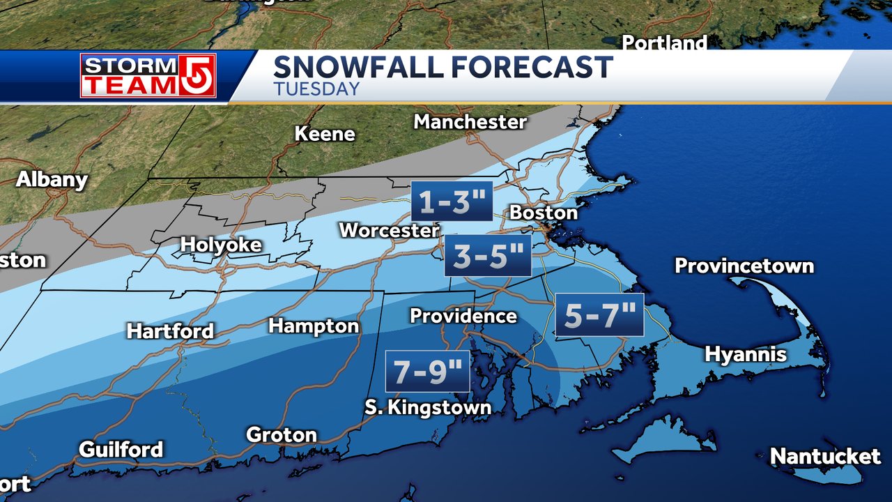
NWS Boston updated its Winter Storm watch….was 4-10 inches yesterday and today it’s 4-8….brought down top amounts. Wonder why…..hmm
.I noticed that but they also upped the amounts on the map to 8-12
-
What are we looking at for onset and end times now ?
-
Just now, Snowcrazed71 said:
I disagree. I'm just west of Hartford and I'm still in the under inch range on the map. We already had just shy of 2 inches from the event today. And if we do get some more tonight that would just add to the totals.
Same thing for my area
-
1
-
-
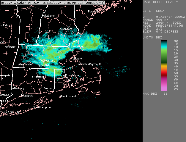
Sharon/Foxboro area got a slushy coating around noon time. I notice nws basically has .2 for the total storm accumulation as most new channels have that area in 1-3 2-4. Curious how tonight will work out, going off nws we basically won’t be getting anything? Have a feeling they are incorrect and too low in areas in the boston-providence line that are away from the coast
-
Are we still expecting some accumulation overnight or has that faded ?
-
4 minutes ago, 40/70 Benchmark said:
It's a very tough call...real PITA storm. I am banking on that area stealing a couple to a few inches based on the slight elevation and being far enough south to get the good lift. Will I be surprised if they get next to nothing?
No.
I hear ya very tough call, I’ll be trying to keep up with the posts here to see how it plays out. Tough call as always for calling out plows. Thank you for the efforts
-
1
-
-
36 minutes ago, 40/70 Benchmark said:
How confident are you in your amounts in the Foxboro area? Comparing to the box map they have close to nothing
-
12 minutes ago, 40/70 Benchmark said:
Hope you do well there, man....been boned so far.
Have you issues a final map
-
10 minutes ago, ORH_wxman said:
Yeah that seems decent. I think even on bad solutions you’ll limp to 2-3” of crapola but you have some upside if you can stay cold enough aloft. Your area is pretty tough. If I was forecasting still for Union I’d be telling the dude “yeah you are probably gonna need plows but it could be 2-3” or 8-9”….stay tuned”
What are your current thoughts for the norton/Mansfield area, most maps have us right on the edge of 2-4/1-3 but the box map seems very unimpressed with this area. How much change do we need to see for this to bump up a little in our area. Havnt had much time to follow along with this one as I usually do so I’m trying to figure out where we sit
-
13 minutes ago, ORH_wxman said:
Nice band rotating south
Is that going to keep going south? Any stickage exptected I didn’t know anything was coming today
-
1
-
-
Seeing a lot of different things as far as the start time goes. Whats the timing look like for the snow to start and also switch over to mix/rain. I’m in the Foxboro area
-
 1
1
-
 3
3
-
-
Are these squalls expected to reach the Foxboro, Mansfield, norton area ?
-
4 minutes ago, ORH_wxman said:
Could be a nice period of moderate to heavy snow over eastern areas looking at this loop. Filling in too south of HVN
Do you think that will make it to the norton ma area as snow or is the mix going to take over there
-
5 minutes ago, CoastalWx said:
I think a few inches there is possible.
Thank you. It seems like it could go either way there. Nothing worse than having a full crew come in and it’s just raining lol
-
1
-
-
Anybody have any thoughts on norton overnight tonight. Have to make a call on plow/shovel crews and really trying to avoid having everybody in place and its just mix/rain all night that doesn’t accumulate.
-
1
-
-
2 minutes ago, TauntonBlizzard2013 said:
Not sure I can think of a storm anytime recently where a realistic outcome for me is 2” or 10”. Wild
What do you think for norton? Same idea
-
Looking at the map box just posted they have a very tight gradient anywhere east of the Foxboro Mansfield area. Their map goes to from 6 inches down to almost nothing right in that area
-
2 minutes ago, alex said:
The roads here are a disaster. Light snow mixed with freezing drizzle, you could ice skate on 302
I meant to put in my post I’m just south of Boston, norwood Foxboro area
-
Do you guys think the roads and parking lots will dry up before the temps drop tonight. Still very wet out right now. Trying to figure if we will need to treat parking lots in the early am or if it will be dried up

The Congrats Dendrite Deck Destroyer 3/23-3/25 obs discussion
in New England
Posted
With temps dropping pretty quickly overnight is ice a concern on the roads? Or will it dry out pretty quick with the wind. Mostly wondering for south of Boston area