

Southern stream
-
Posts
44 -
Joined
-
Last visited
Content Type
Profiles
Blogs
Forums
American Weather
Media Demo
Store
Gallery
Posts posted by Southern stream
-
-
2 minutes ago, Upper Level LOL said:
Oh I agree Wednesday is a super serious threat. I was just more highlighting that Albedoman’s jeremiad about EF4-EF5s this far out is kinda irresponsible (and his definition of tornado emergencies is incomplete).
Agree! I would honestly say throwing out predicted numbers and intensities is altogether, irresponsible. Just the fact that alot of this event will occur in the evening/overnight makes it a very dangerous situation.
-
Although this is no promise of active weather, definitely a step in the right direction.

-
 1
1
-
-
With all of the historic flooding around here, many of us need a break for the next several days so no complaints here.
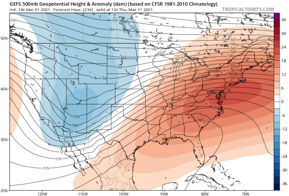
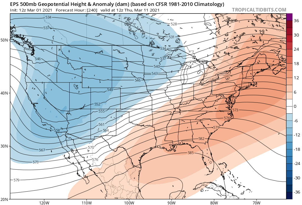
Height anomalies look encouraging toward mid March. More of a typical trough west/ridge east scenario. Jet pattern really amplifies around that timeframe.
-
2
-
-
PAH and LMK will more than likely up areas to warning headlines by morning, based on the 0z runs a good (maybe even conservative) 6-10"+ swath looking probable considering the ratios we will be dealing with in an arctic airmass. Hopefully you peeps up to my north/northwest can get in on the action too.
-
Okay, I noticed there is a relative lack of southern/eastern sub-forum members posting on this event so I decided to hop in. Long time lurker of 6 years, from NW KY. It's been quite awhile since I have seen this much consensus on a 6"+ storm for the Lower OH Valley. Excited to say the least! Was somewhat questioning last night's 0z GFS sporting the progressive bias, but pretty much all late evening runs have corrected back to the west. Thankfully this go around we won't have any icing issues in my vicinity, received almost .50 of that from the ice storm a few days ago.
-
Slight risk has been added for Wednesday. Looks to me like mainly a Damaging wind threat. Haven't looked in detail at soundings this morning. The NAM last night (at that point the outlier) was showing a decent LL veering, but the rest of the column was pretty well unidirectional. Hence I think even with that solution, the main tor threat would be brief spinups along a line. Atleast in my immediate area, models are generally in good agreement, bringing a complex through mid/late evening.
.png.9f871bf7b1c3b73ab1e43c26b79ee541.png)
-
Biggest question for central OK was if we could get CI and could it be maintained. That appears to be the case as of this moment with every shower going up already trying to take on the kidney bean shape.
-
Showers S of OKC. appear to be persisting and slightly growing. Cant believe we are seeing initiation happening so far south.
-
Cell NW of Wichita Falls appears to be holding it's own, seeing increase in lightning. Edit: Now SVR warned
-
You can only hope people will take today seriously. Having an event like Monday happening not even 2 days ago really worries me that some are going to play this off like it's nothing still being complacent from Mon underperforming.
-
41 minutes ago, westhope84 said:
For the more knowledgeable members here: Does it appear possible a PDS watch will be issued for NE OK and adjacent areas north and east?
Possible but Ive seen days like this not have a PDS. Even if there isn't, still potential for significant tornadoes today.
-
 1
1
-
-
5 minutes ago, StormChazer said:
Same, but I could also see them being a little gun shy after Monday, but we will see!
Exactly! I've been pretty cautious of the HRRR since, but as Quincy just stated flooding is gonna be a major problem again with training Sups. I cant remember seeing such a water logged pattern in the Plains. SE ridge is keeping us out of the main storm threat in KY though, a little bummed.
-
Upgrade at next update wouldn't be a huge surprise based on the environment and notion that there is agreement on convection developing in the region, next outlook will be interesting.
-
2 minutes ago, Misstertwister said:
More incredible than Monday’s? I know that didn’t yield what was forecasted but it was talked about several days out
Not to the level of Monday. But you dont have to have a historically high end environment to do big things. It only takes a very small subtle change to affect things on the large scale when it comes to an outbreak, and Monday was a very good example.
-
We will have a much better picture by midmorning. The storm environment is very interesting to say the least and very much supports all hazards, so long as we get sustained convection.
-
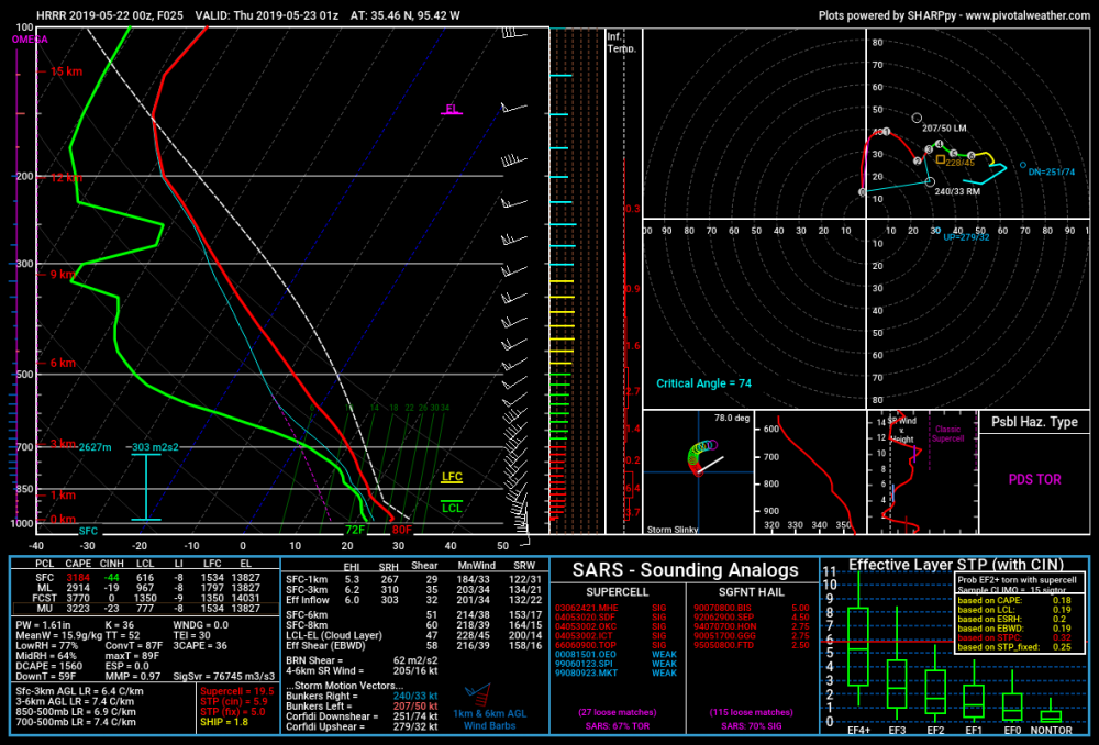
HRRR Sounding from NE OK tomorrow afternoon/early evening. VERY questionable after the Monday turnaround at the last second, but that is showing some potential maybe even of MOD risk caliber. Last I checked, NAM 00z from around the same timeframe wants to keep a stout inversion in place around 850mb severely hampering convection. Guess it's just a waiting game to see what trends are through tomorrow afternoon. My gut is telling me the NAM may be onto something again.
-
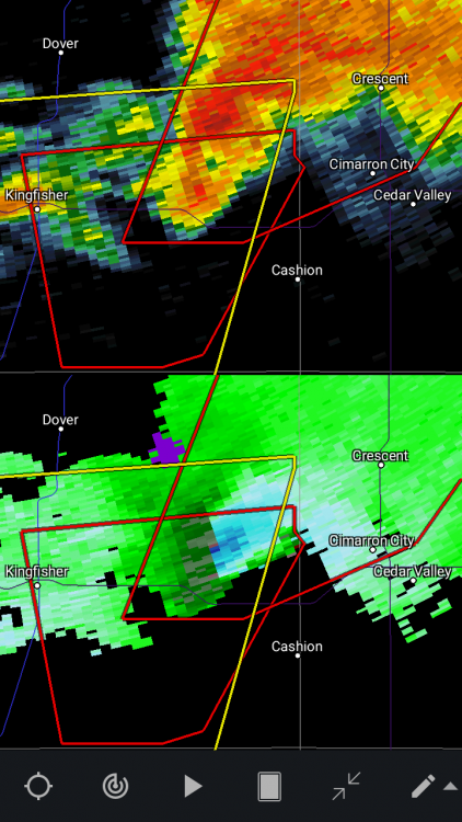
BWER and strengthening velocities on the Kingfisher storm
-
As we have seen a select few times, we are about to see what results from a dangerous mixture of extreme thermodynamics and intense wind shear. Its NEVER good.
-
2 minutes ago, SandySurvivor said:
the tornado threat from sandy was more serious than this setup
Stop trolling. Today is not the day for that.
-
3
-
1
-
-
Am I the only one that thinks this event needs it's own thread? But new to the site so maybe not.
-
13z would be the best deciscion to pull the trigger IF they did. It would give them a much better idea of how morning convection will behave and more time to watch overnight CAM runs for any trends.
-
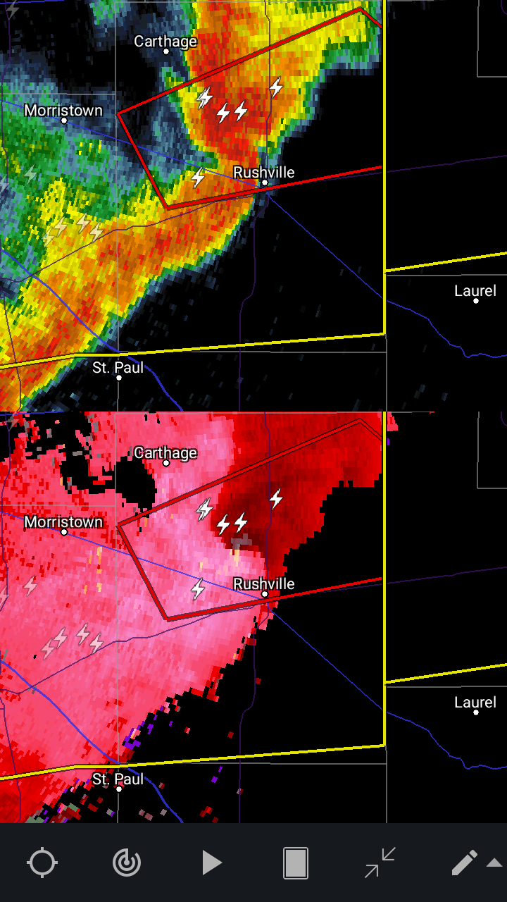
Nice little embedded supercell there.

-
Definitely still looking like a dangerous setup. Will it be our first High risk of the year? This is a parameter space that supports one, but Ive seen lots of people on twitter thinking we could even see a D2 high. 99.9% chance that will not happen. Seeing how careful and conservative they have been on pulling the trigger for a higher risk this year, they will much more likely wait (the smart thing to do), until the morning of, to get a much better idea of mesoscale details. Not to mention the idea of a D2 high occuring is extremely uncommon and last I checked, only has happened on 2 other days. Me personally, I think D2 outlooks having a max ceiling of MOD would do just fine and get the message out just as effectively. In general though it is looking like potentially the biggest event in the southern plains in several years should parameters hold.
-
Climatology leans toward late May as getting toward our last chances to get a significant event in the Lower OH valley (South IN/South IL/West KY) tornado wise, minus maybe the early June of '90 outbreak. May 30, 2004 and May 25, 2011 are the last major late May events I can remember but correct me if wrong please, and both coincidentally were High risks. Still plenty of wind events through June and July on average but with the main jet energy shifting north toward the northern plains and upper midwest, thats usually about all we tend to get in those months. We have had setup after setup this season that was very favorable on a large scale for some big things, but instability and mesoscale issues have constantly dampened them to a conditional threat that never materializes. This upcoming pattern looks like our best shot so far this spring at something big, and IMO climatologically late May is getting toward our last bit of tornado season down this way.


March 17-18 Severe Weather Event
in Southeastern States
Posted
Impressive, SE MS rapidly becoming active.