

bjc0303
-
Posts
291 -
Joined
-
Last visited
Content Type
Profiles
Blogs
Forums
American Weather
Media Demo
Store
Gallery
Posts posted by bjc0303
-
-
1 hour ago, Chinook said:
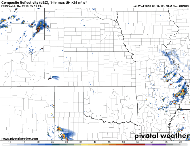
Here's something a little off topic. I have noticed today that the 18z 3-km NAM products, as shown on PivotalWeather.com and College of Dupage, have taken from 18:00z till 23:00z, 5 hours, and they're not even completely done. This does not take so long for the 00z 3-km NAM products. Is NCEP just processing that much more computational stuff during the mid-day time?
Think it’s an issue with the feed
-
I don’t have much to say about Friday but one thing: outflow boundary.
global and mesoscale models indicate a SEward propagating upscale growing segment will move through SW Ne and N/W Kansas. This is depicted well by the 3km NAM and falls in line with low level flow anticipated. In the wake of the decaying activity Friday morning... all eyes will be on this boundary.
-
Moisture is going to continue to be a limiting factor (as will weak shear in the deep layer). Moisture is pretty meh for the time of year thanks to the ULL in the gulf. Unfavorable trajectories should persist for quite a while. Ie, plains dealing with recycled/processed moisture rather than rich Caribbean trajectories.
While Friday and Saturday could yield fun chase days, think that overall ceiling will be tempered by lack of richer low level moisture. 2018, you never cease to amaze.
Severe opportunities should continue into parts of next week, perhaps shifting north. Ensembles depict potential activity for the northern plains closer to Memorial Day
-
 1
1
-
-
21 minutes ago, Quincy said:
Last week, May 6-12, was a staggering 91% below climatology (based on preliminary reports) in terms of tornadoes with only six. The only such period that saw fewer since 1950 was four in 1987.
Might be time to close the door on May and look ahead to June. Unfortunately for me I will be at a camp June 3-17 with no phone or internet lol. Send your pics to Maxwell AFB folks.
-
I know calling things a wedgefest is a meme and all, but the 00z euro dropped and absolute dime on the plains at hour 240 last night lol
-
2
-
 1
1
-
-
This week has looked like a dud for days now, but all signs suggest activity ramping up next week and continuing into the end of May. Could be looking at a prolonged stretch of activity. Finally the season may get going.
Deterministic guidance, as well as ensemble guidance really favor uptick in activity for a large part of, if not the remainder of, May.
-
4
-
-
The propensity for updrafts to collapse on themselves thanks to weak effective bulk shear have this looking like a non-event. Still could get some brief spinup out of a cluster or something, but I see this as a cluster/multicell storm event with low level shear leading to upscale growth in the early evening hours. Storm rotation will be possible and I suppose you'll see some interesting looking clouds at times, but tendency will be for updrafts to be choked off by cold pools. Largely a wind event.
The lone exception is if you get enhanced wind shear along any remnant outflow boundaries. I think that is a pretty big if, and won't be discernible at this range.
-
1
-
-
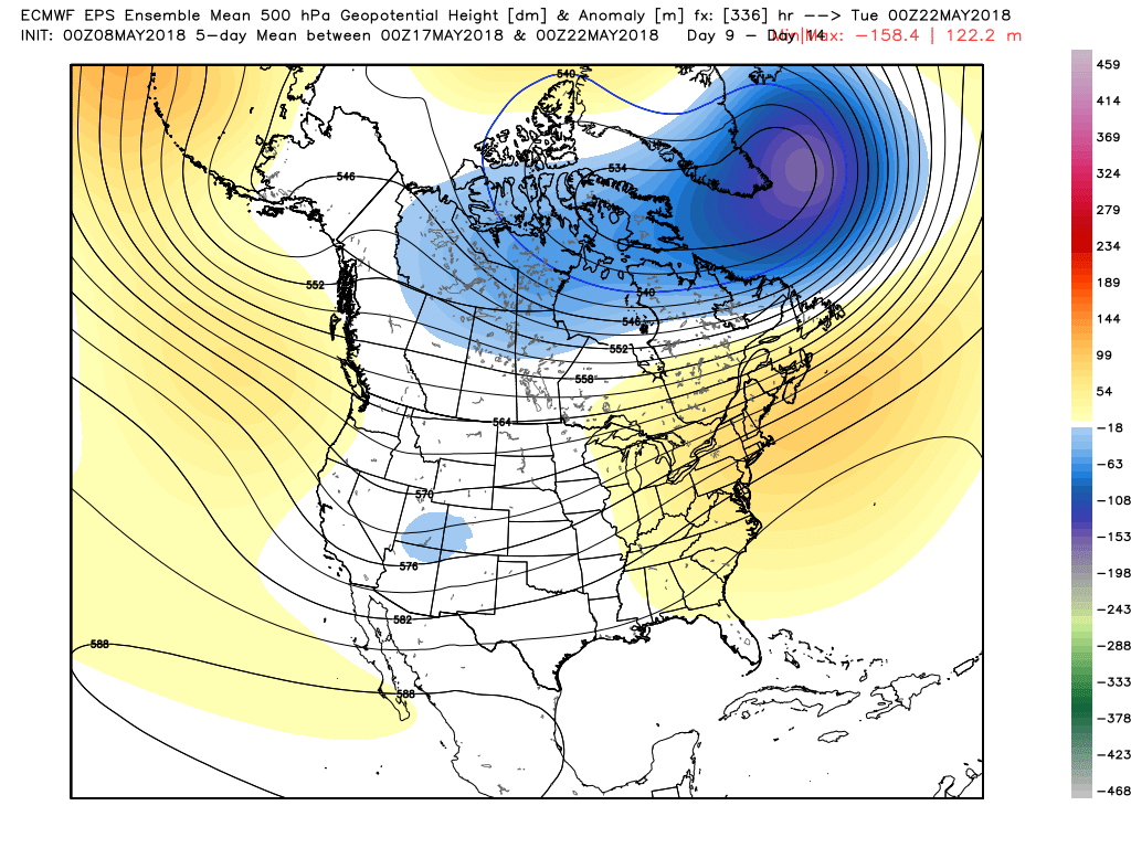
ECMWF, GFS, CMC, and FV3-GFS parallel all introduce western troughing in the 240 hour timeframe.
GEFS, CMCE, and EPS all introduce western mean troughing about this time period. I honestly cannot help but get pretty excited looking at the Euro EPS mean. The evolution suggests extended southwest flow aloft, with a wide range spatially and temporally of targets. Details will not be clear for a long time, and at this range, even the ensemble could be fooled. Ensembles do exhibit noticeable skill in the 10-14 day window, though (as in skill > climatology). So while things will change, confidence does appear to be increasing slowly on prominent western troughing mid-late next week. This could be a period that helps make up for a lot of the downtime we've had this year.Here is a five day mean of heights centered on May 20th:

Here is the evolution as a whole on the EPS (mean):

After such a bleak opening, there appears to be reason for optimism going forward.
-
4
-
-
On 5/2/2018 at 11:10 AM, nrgjeff said:
CFS had a bad run as did the 00Z GFS. However the 06Z GFS came back around to Euro Ensembles. Consensus still looks good. Euro weeklies look good. Just hold on Thursday night, lol!
Ensembles/clusters all point to increasing confidence week of May 14. Week of May 21 is likely on the table too. Well, also climo. Week of May 28 and first week of June have excellent climo.
Cannot punt a season based on April, or one quiet 5-days in early May. 2018 is waking up, and I think the ruckus is just beginning!
GWO and MJO would definitely support a surge in activity the back half of May.
-
1
-
-
1 minute ago, StormChaser4Life said:
Hopefully won't get in trouble for posting this. Winds aloft not looking as westerly as before. Jet has more amplitude this time around and not as flat
Says 00z.. the site basically lets you see the 12x frames up until you exceed what has come in, then you’re looking at 00z data.
-
3 minutes ago, StormChaser4Life said:
Well 12z euro took a step in the wrong direction. Hopefully just a bad run and not a trend. Looking more GFS like
What... 12z hasn’t started lol
-
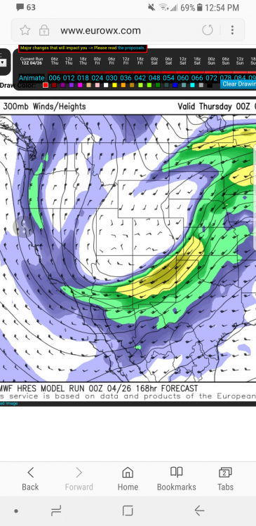
00z euro for Wednesday looks rather potent. QPF field suggests long lived scattered activity.
-
2
-
-
A little skeptical of persistence here given near unanimous signal for western ridging to return after the passage of this trough. Euro looks capped for Monday. Tuesday is “the day.”
-
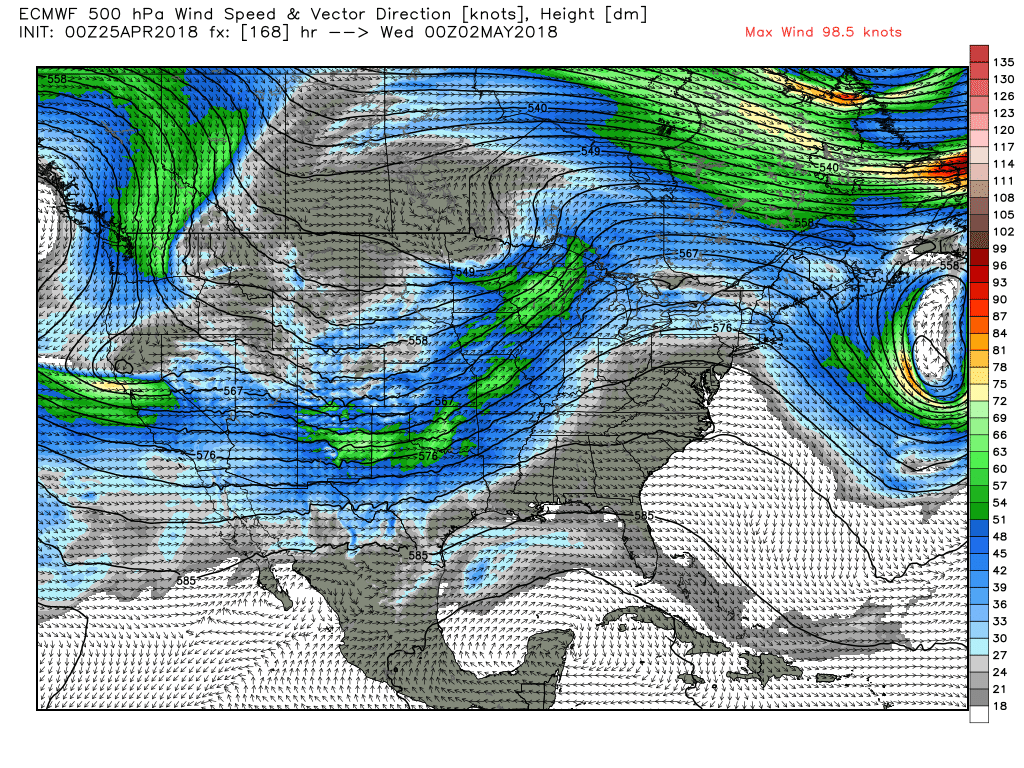
21 minutes ago, StormChaser4Life said:
I wasn't able to see the upper levels on the site I use for Euro. However I did like the strong sfc low shown near the panhandles. Gfs had a similar position albeit weaker. The moisture and cape were great. What did the jet orientation look like? Seems like models are trending less positive tilt now
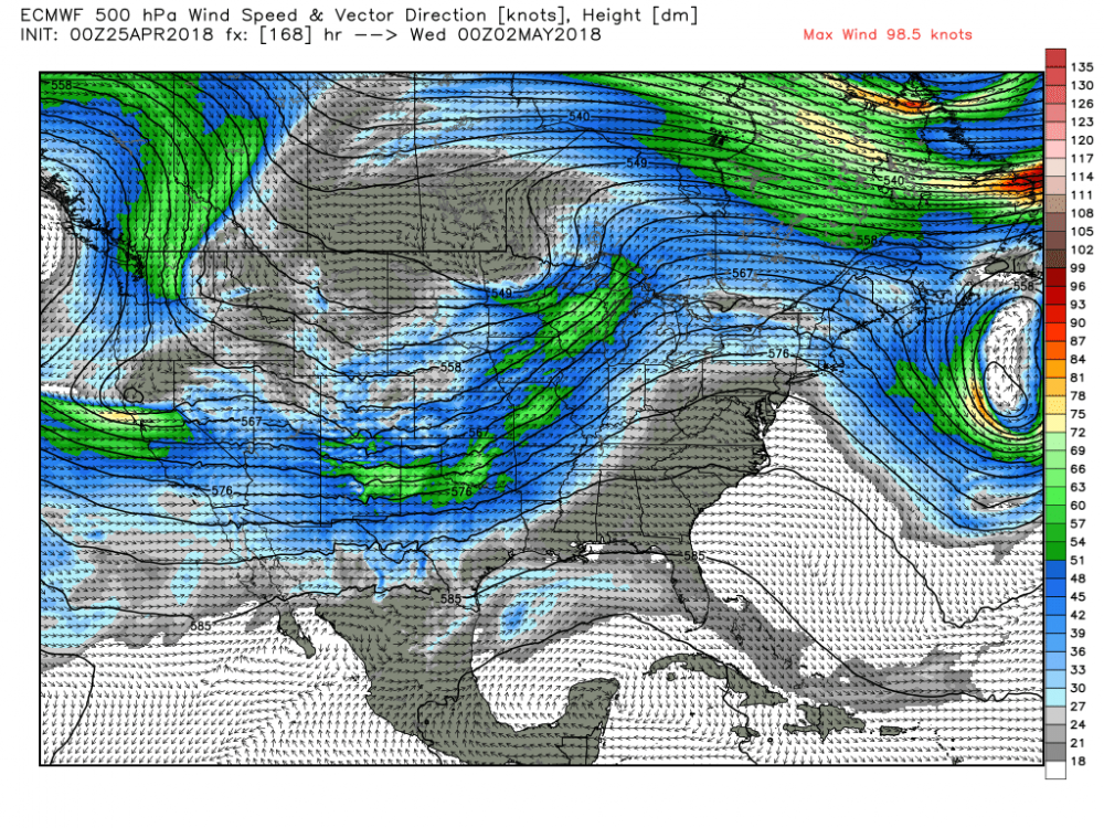
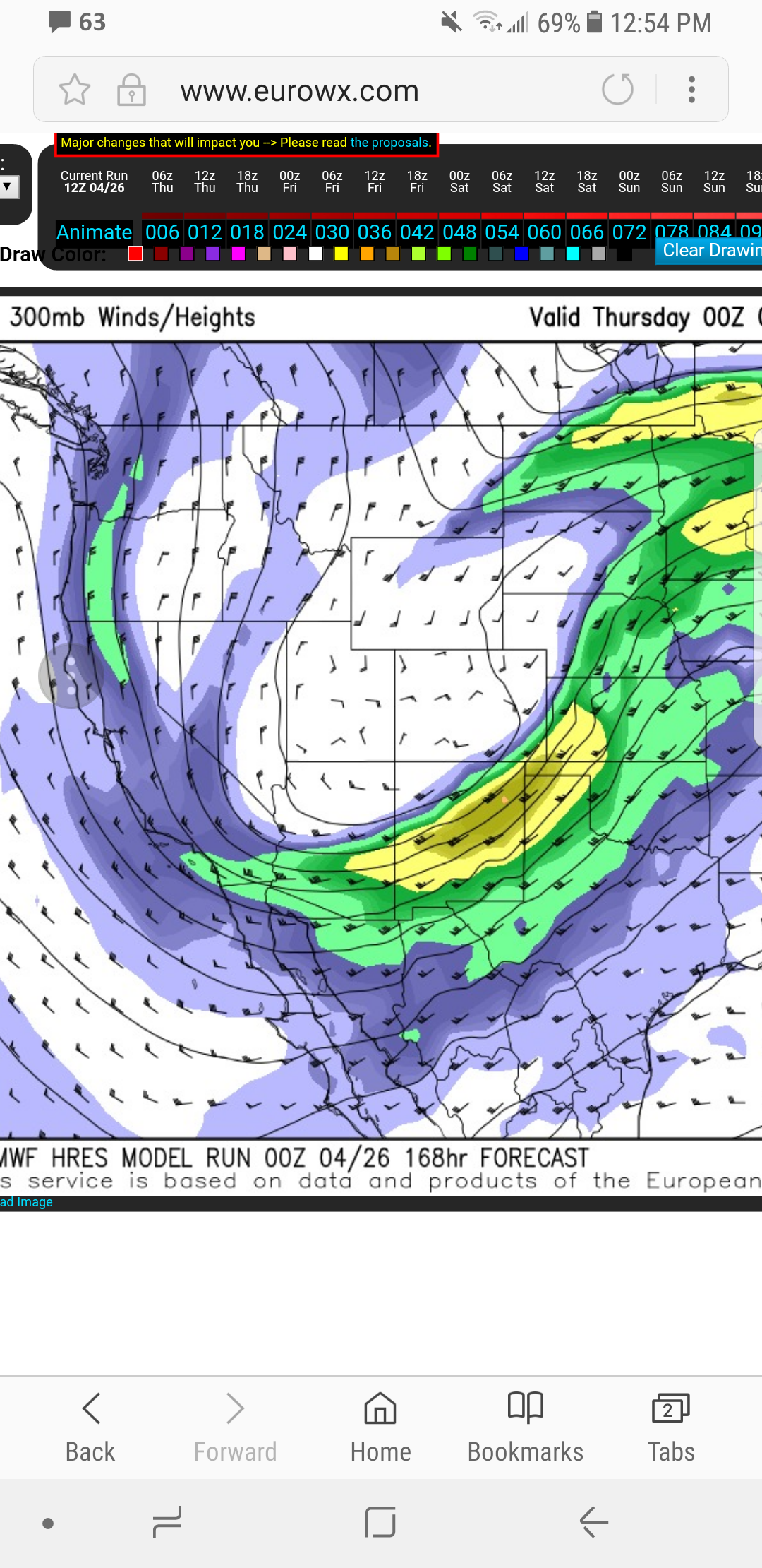
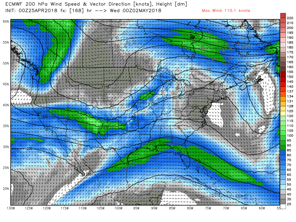
H500
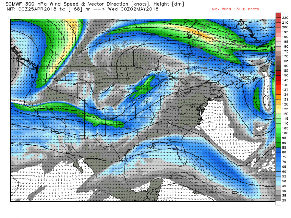
H300

H200
-
1
-
-
Just now, NWLinnCountyIA said:
I wouldn't call next week's setup ideal... it's got problems. Particularly problems with moisture(especially on the euro side of things) and the GFS digs the trough deep enough such that 500mb orientation is mediocre at best. I'm not seeing an outbreak, but I'm seeing perhaps a few events in the plains from this.
On the flip side of my post is this: you can’t write anything off this far out.
Do you believe the trough will really get that far south, as the GFS portrays?
Will the cold front be as strong as progged by the ECMWF? Seems somewhat harsh if you ask me.
These are are all valid concerns but to make definitive statements about next week at this moment is plainly silly and lazy.
-
22 minutes ago, jojo762 said:
Not even optimistic for what amounts to an ideal synoptic setup with a trough digging into the four corners while a strong ridge dominates the east coast? Hmm...
Trend for a positive tilt configuration not exactly chaser friendly. Some too amplified, some solutions quite weak.
I also wouldnt call the image posted “ideal” at all. Ideal is a broad wave with strong perturbations emanating from the west over the warm sector. Overlap between favorable instability and kinematics could be small.
Biggest positive is the prominent eastern ridge progged by nearly all guidance. It’s still way too far out to sweat details, but that goes both ways. Could be a slopfest, could be a fun time. Although moisture looks like it won’t be there in time for the first day (Monday), especially on the euro. Best kinematics seem to come Monday on the euro at a glance, although Tuesday looks solid just not in the best terrain. Monday is severely moisture deprived. But again, not worth sweating the details. There will be severe next week.
-
 1
1
-
-
Still can’t feel too excited for a number of reasons, but I’ll wait.
-
1
-
-
4 hours ago, WhiteoutWX said:
Euro doesn't look anything like the GFS unfortunately with relatively weak flow across most of the plains. Still like 10 days out there and definitely a period to watch (the only thing to watch at this point).
Yeah, I’ll reserve getting too excited until the euro/ensemble jumps onboard. But at least there’s something to monitor.
-
1 hour ago, CheeselandSkies said:
*Sigh.* Already steeling myself for another wasted spring. What does it take to get an active severe pattern this decade (after the extremes of April 2011, of course)? La Nina, El Nino, anomalous warmth, anomalous cold, nothing works. Need to see a year where events like June 16th-18th, 2014, April 9th, 2015 and May 24th-25th, 2016 are part of a sustained pattern and not just diamonds in the rough...and this isn't going to be it.
lol @ calling the season before May first....
You have no idea what May is going to bring. Just stop.
-
1 hour ago, Quincy said:
The 12z EPS is pretty awful, with Great Lakes troughing right through day 15.

Yep, just looked at the 12 eps lol
-
23 minutes ago, WhiteoutWX said:
There always the chance for late May magic, I’m reserving calling the season for at least another few weeks, even as bad as things look at the moment.
Just as folks are calling it, I’m seeing some interesting stuff in the extended in both euro and gfs ensembles.
-
1
-
-
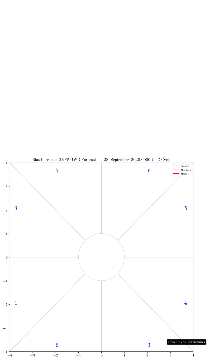
36 minutes ago, WhiteoutWX said:
Can you elaborate on why the GWO phase space plots have you concerned? From everything I’ve read Phases 1/2 are the best phases for tornado activity in the US. The current GEFS forecast has us solidly in phase 2 in about 5 days, with the long range taking it into high magnitude phase 2 territory. Is there something else you were seeing?
Need to look at bias-corrected GEFS forecast:
-
I don’t care too much for the analogs honestly. Severe wx depends too much on mesoscale factors to even care, in my opinion. People are crying too much about things we have zero control over and little (if any) predictive ability over. May could suck, May could also go out with a bang a la 2013. We won’t know for weeks, so as awful as the pattern looks ahead (and it does look quite awful), we are nowhere near reaching any respectable level of predictability wrt severe potential in May.
The GEFS GWO phase space plots do have me somewhat concerned but again, even that hardly touches on May at this point. At some point it comes crashing down and climo wins out. If we still see progs like this by May 10th, then I’ll talk about reaching “awful May” status.
-
2
-
1
-
-
Yeah as far as the moist axis goes... it’s totally fine. The meager instability is not owed to the quality of moisture (at least not near the dry line).

Central/Western Medium-Long Range Discussion
in Central/Western States
Posted
Not going to lie, I am intrigued by the next few days for supercell/tornadoes. Doubt anything materializes Weds/Thurs, but intriguing potential nonetheless.
Also a fan of tomorrow's severe weather setup, if approached from the perspective of "it's a summer pattern."