
.jpg.99549b9488c2d4c74c38a2309f7903c2.jpg)
Huriken
-
Posts
96 -
Joined
-
Last visited
Content Type
Profiles
Blogs
Forums
American Weather
Media Demo
Store
Gallery
Posts posted by Huriken
-
-
4 hours ago, jjwxman said:
CWASP Percentages via the 6z NAM on Sunday afternoon.

The NAM seems to be very bullish for Sunday's event. Taken verbatim, anything that develops ahead of the squall line would certainly be capable of producing tornadoes.

-
D4 severe risk for VA down into FL
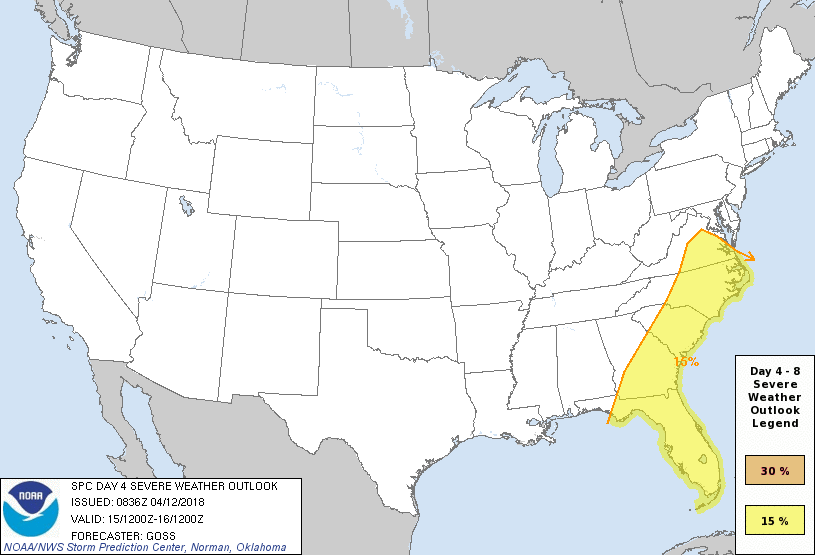
Day 4-8 Convective Outlook
   NWS Storm Prediction Center Norman OK
   0336 AM CDT Thu Apr 12 2018

   Valid 151200Z - 201200Z

   ...DISCUSSION...
Latest runs of the medium-range models are exhibiting fairly
considerable differences from one another with eastward progression of an eastern U.S. cold front Day 4/Sunday.  The differences in handling of synoptic features become even more pronounced beyond, as the next Pacific trough enters/crosses the U.S. in the Day 5-8 time frame.

   Despite the Day 4 variability in the models, it is apparent that an ongoing line/band of storms will progress steadily eastward across the Appalachians early in the day, and then continue east across the Atlantic Coast states.  While warm-sector instability remains a substantial uncertainty -- in part due to variability in the speed of the frontal advance toward the coast -- the kinematic environment will support organized convection.  As such, will introduce a 15% area extending from parts of Virginia south to Florida, with damaging wind likely to be the predominant severe risk until frontal convection moves offshore.
-
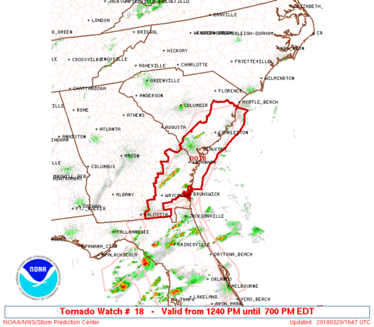
SEL8 URGENT - IMMEDIATE BROADCAST REQUESTED Tornado Watch Number 18 NWS Storm Prediction Center Norman OK 1240 PM EDT Tue Mar 20 2018 The NWS Storm Prediction Center has issued a * Tornado Watch for portions of Southeast Georgia Coastal South Carolina Coastal Waters * Effective this Tuesday afternoon and evening from 1240 PM until 700 PM EDT. * Primary threats include... A few tornadoes and a couple intense tornadoes possible Scattered large hail and isolated very large hail events to 2 inches in diameter possible Scattered damaging wind gusts to 70 mph possible SUMMARY...Scattered to numerous storms are expected to develop across the coastal plain this afternoon ahead of a cold front. Some of these should be severe with a risk for tornadoes, large hail, and damaging wind. The tornado watch area is approximately along and 55 statute miles east and west of a line from 35 miles south southeast of Waycross GA to 55 miles north northeast of Charleston SC. For a complete depiction of the watch see the associated watch outline update (WOUS64 KWNS WOU8). PRECAUTIONARY/PREPAREDNESS ACTIONS... REMEMBER...A Tornado Watch means conditions are favorable for tornadoes and severe thunderstorms in and close to the watch area. Persons in these areas should be on the lookout for threatening weather conditions and listen for later statements and possible warnings. && OTHER WATCH INFORMATION...CONTINUE...WW 17... AVIATION...Tornadoes and a few severe thunderstorms with hail surface and aloft to 2 inches. Extreme turbulence and surface wind gusts to 60 knots. A few cumulonimbi with maximum tops to 450. Mean storm motion vector 25035. ...Grams -
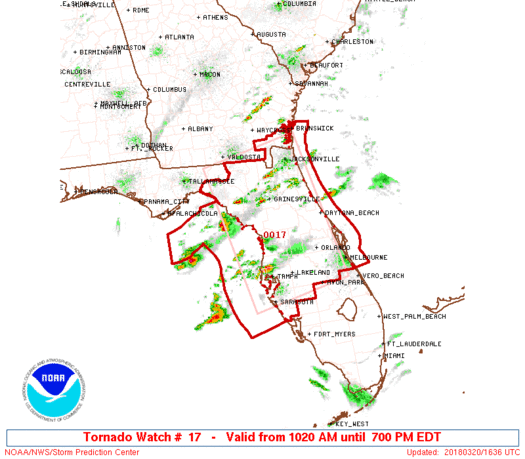
SEL7 URGENT - IMMEDIATE BROADCAST REQUESTED Tornado Watch Number 17 NWS Storm Prediction Center Norman OK 1020 AM EDT Tue Mar 20 2018 The NWS Storm Prediction Center has issued a * Tornado Watch for portions of Northern and central Florida Far southeast Georgia Coastal Waters * Effective this Tuesday morning and evening from 1020 AM until 700 PM EDT. * Primary threats include... A few tornadoes likely with a couple intense tornadoes possible Scattered large hail likely with isolated very large hail events to 2.5 inches in diameter possible Scattered damaging wind gusts to 70 mph likely SUMMARY...Scattered severe storms are expected through this afternoon, capable of producing tornadoes, large hail, and damaging winds. The tornado watch area is approximately along and 75 statute miles either side of a line from 60 miles west northwest of Jacksonville FL to 35 miles west southwest of Avon Park FL. For a complete depiction of the watch see the associated watch outline update (WOUS64 KWNS WOU7). PRECAUTIONARY/PREPAREDNESS ACTIONS... REMEMBER...A Tornado Watch means conditions are favorable for tornadoes and severe thunderstorms in and close to the watch area. Persons in these areas should be on the lookout for threatening weather conditions and listen for later statements and possible warnings. && AVIATION...Tornadoes and a few severe thunderstorms with hail surface and aloft to 2.5 inches. Extreme turbulence and surface wind gusts to 60 knots. A few cumulonimbi with maximum tops to 500. Mean storm motion vector 26035. -
Just thought I'd put this here...
https://mobile.twitter.com/NWSWakefieldVA/status/953365789930909698
-
We'd be talking a greater threat if it weren't for the meager instability. Looks to be another case of a low CAPE/high shear event, but to be expected for this time of year, of course.
-
3 hours ago, FallsLake said:
As I said before, in this pattern of suppression we may have to pin our hopes on a clipper. Usually clippers stay just a little too far north for many on this board but with these massive highs and deep troughs we can now score. The last two runs of the GFS show something at ~ day 9. It's definitely too far out to get excited about but I believe this more that a big storm showing 5 days out.
6z GFS (similar to the 0z):
Better than nothin', I suppose. Hopefully it doesn't disappear or get squashed!
-
I'm bout ready for a warmer pattern. No snow, no cold!
Bring on the thunda!

-
Let's take that HP and push it somewhere else!
-
So are most of the models showing nada for the New Years "storm" too?
-
Why don't y'all just look at the positives in life. At least we got the cold!
-
16 minutes ago, BornAgain13 said:
Euro is another big hit!
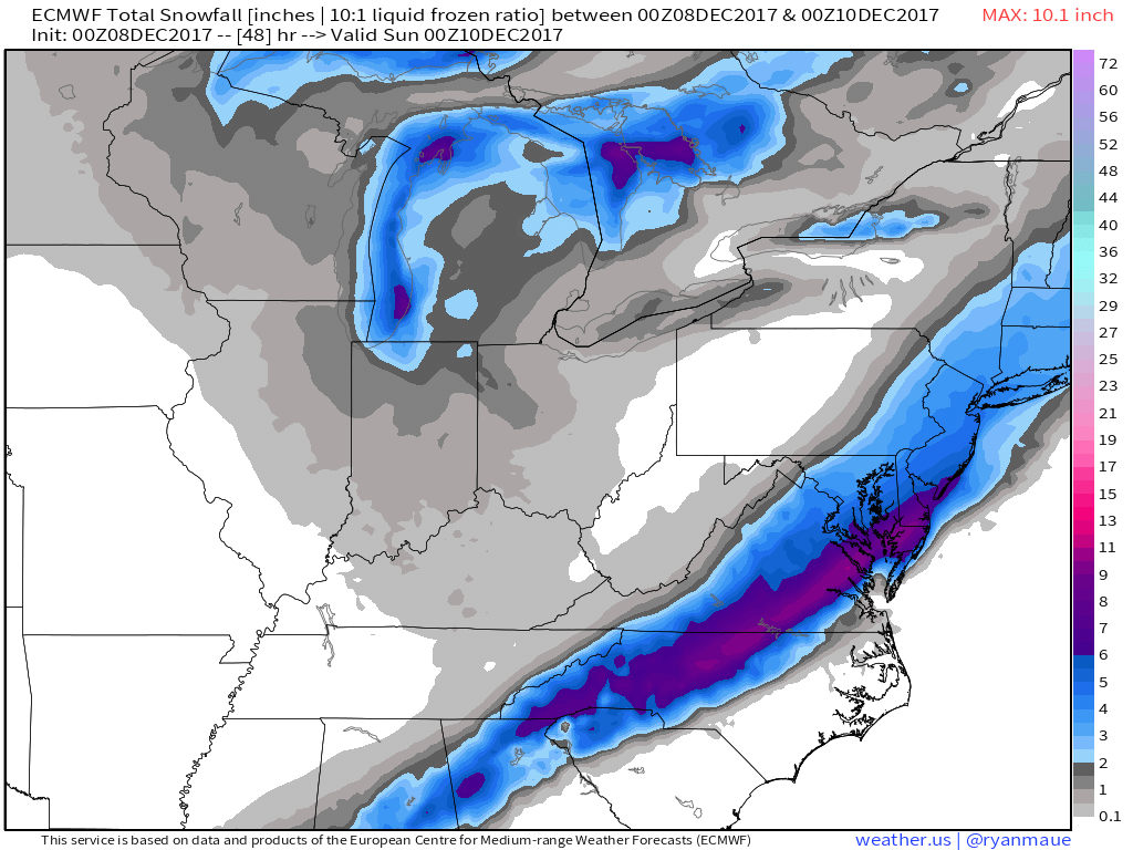
Wow, this escalated pretty quickly for my area. I was only expecting an inch but it seems I could get 3+ inches now. Although it could go the other way around...
2018 General Severe Weather
in Southeastern States
Posted
Current Day 3 SPC outlook: