

Tucker1027
-
Posts
139 -
Joined
-
Last visited
Content Type
Profiles
Blogs
Forums
American Weather
Media Demo
Store
Gallery
Posts posted by Tucker1027
-
-
It must be snowing everywhere in chatt and surrounding areas. Cant seem to get it to switch over in Red Bank.
.
Downtown hasn’t fully switched over either. My mom who lives in Georgetown about 8 miles north of Ooltewah has an inch in about an hour.
.-
 2
2
-
-
Huntsville just put North Alabama under a WSW just now
.-
3
-
-
It’s snowing in Cleveland now
.
Yep my mom just sent me a video. She is in Georgetown.
.-
2
-
-
For what it’s worth the new HRRR has Chattanooga to snow by 1 which is earlier than expected
.-
4
-
-
I am right at the foot of Lookout Mountain here in the St. Elmo area of Chattanooga. Definitely have a lot of mixing going on here right now, seems to be about a 50/50 mix of rain and snow. Seems to be skewing more towards snow over the past 10 minutes or so.
I’m about 3 minutes from you and can confirm. Hopefully we can switch over
. -
I’m at the foot of Signal and have never been more jealous in my life

.-
2
-
-
Another friend has Snow mixing in about 4 miles south of Chattanooga..
.-
3
-
-
Just got a report from a friend that it is snow hard on signal and sticking now.
.-
3
-
-
We need the ULL to over preform correct?
. -
I will say I’m encouraged our Low is in the gulf and not on the Florida/Alabama line.
The next couple hours are important to see if the Low cuts or not.
. -
I know I’m wrong, but I think we are going to be surprised by this storm. I had the same feeling with the 2014 storm.
.-
2
-
 1
1
-
-
Special Weather Statement
National Weather Service Morristown TN
951 PM EST Sat Jan 15 2022
TNZ067-068-071-083>086-099>101-161000-
Roane-Loudon-Northwest Blount-Rhea-Meigs-McMinn-Northwest Monroe-
Hamilton-Bradley-West Polk-
Including the cities of Harriman, Eagle Furnace, Rockwood,
Bradbury, Fairview, Kingston, Oliver Springs, Lenoir City,
Loudon, Happy Valley, Maryville, Alcoa, Dayton, Evensville,
Old Washington, Grandview, Spring City, Big Spring, Athens,
Clear Water, Dentville, Etowah, Sweetwater, Madisonville,
Bullet Creek, Chattanooga, Cleveland, Tasso, Conasauga,
Archville, Benton, Parksville, and Reliance
951 PM EST Sat Jan 15 2022
...Wintry Weather Possible Sunday For The Southern Tennessee
Valley...
A potent storm system will move through the region tonight
through Sunday night. This system will produce light snowfall
across the southern Tennessee Valley on Sunday which could yield
measurable snowfall less an inch total. Some of the locally
higher elevation areas could see slightly higher snowfall totals
of 1 to 2 inches, which is expected to remain isolated. This
precipitation could present some minor travel impacts across the
region on Sunday and Sunday night.
.-
1
-
-

Looks like the low is in South Alabama
.-
1
-
-
Nice wind from the north in Chattanooga…
.-
1
-
-
Low go home your drunkzzz

.-
1
-
 1
1
-
-
Yes it will. Brutal on soft timber though.
.
Yes, it is. I drove through the Cherokee National Forest after the storm on the 2nd aback from Cherokee and this was the scene
.-
2
-
1
-
 4
4
-
-
Yep. Bill Race is normally conservative. He was showing 1-3" in the valleys but he did go low and said immediate Chattanooga area 0.6". Hell, no one knows at this point.
Sent from my moto z4 using Tapatalk
Honestly I love tracking these winter storms, but this one is ridiculous. No one knows.
.-
5
-
-
Not something I see very often Chattanooga local TV WTVC News Channel 9 is not aligning with the NWS and channel 9 tends to be pretty conservative with snow but they are saying 1"-3" valley and 3"-6" or higher mountains. I think that is more reasonable than MRX forecast.
Haven't checked Knoxville local stations, I live in an area where both cities TV stations are available.
https://fb.watch/az7tq0RViK/
Sent from my SM-G965U using Tapatalk
Which is big change of course from them… they were talking about not seeing anything this morning.
.-
2
-
-
It looks like it is still digging to me. I think it will make a run at the Gulf:
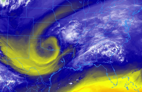
Nice t-storms starting to pop there too (thankfully not parallel to the coast to cut off moisture.
Will this help the valley?
. -
Here in Knoxville we have been socked in with thick clouds all day long and temps are well below forcasted highs
Same. We were supposed to get up to 47-48 here today in Chattanooga, but I don’t see it.
Currently: 42 with Light Rain
.-
1
-
-
MRX...nothing to see here...move along lol

Spann said Huntsville was putting out watches later today so we will just be a hole in a sea of winter.
.-
1
-
1
-
-
Looks like a "realistic" possibility. We'll see. Seems like maybe things are starting to come back to us after the crazy model runs for most of the day.
I have seen several times with winter storms that we lose the models about 36 hours out, but sometimes they will swing back to us.
.-
2
-
-
This is rough.. I keep hoping we will see a change that is beneficial for the valley, but I am loosing hope for Chattanooga and the valley.
.

Jan 16-17th Boom or Bust
in Tennessee Valley
Posted
I would take 2-3 inches off that. Wouldn’t cut it in half since we started earlier than expected, but probably 5 inches of this keeps up till 6
.