

mikem81
-
Posts
1,113 -
Joined
-
Last visited
Content Type
Profiles
Blogs
Forums
American Weather
Media Demo
Store
Gallery
Posts posted by mikem81
-
-
2 minutes ago, MJO812 said:
Upper levels don't look bad on the gefs. This is for the taking.
.thumb.png.1cdf23b59ff0a1644ba0ba1d0399ae05.png)
.thumb.png.5c931865edf4dbccbedff611f860573f.png)
This is the surface map not upper levels. Don’t see this coming up the coast unless there is a late capture like Boxing Day or Jan 2022. Similar storms came up coast from florida and needed to get pulled back in. Really impossible to know if that can happen here
-
 1
1
-
-
To me this seems to be all of nothing. Either it gets captured just in time and comes up to Delmarva latitude or doesn’t and shunts east at NC
-
Really just need the ULL to capture the souther stream and keep it at the coast longer. Some would call it a slight tug or yank
-
2
-
-
18Z icon just your typical 100 mile shift every cycle
-
 1
1
-
-
Just now, MJO812 said:
JB is also saying how H5 looks good on the Euro but the surface isn't and should be further west.
Watch Bernie Rayno’s new video as it explains why this storm just isn’t going to come up the coast. Damn kicker pushing the ULL to form too far east and keep trough positively tilted. Not sure what JB is referring to as the ULL position seems to be obviously east
-
1
-
-
Bernie Rayno had decent video. Essentially blaming the energy entering the west coast kicking the ULL formation east of yesterdays runs
-
Just now, mikem81 said:
The ULL actually
appears to consolidate earlier at better on the more recent EURO runs. Don’t really understand how this is translating into the offshore results. I can see the GFS result with the ULL never
really getting its act together until it’s too late but the EURO h5 seems weird to produce what it is showing
If someone can look at h5 from yesterdays 12z euro and compare to todays and somehow explain why the surface is so Much worse today is really appreciate it.
-
 1
1
-
-
1 minute ago, psuhoffman said:
It does but it’s unusual for a closed low that far northwest of that amplitude to produce a wave that escapes south of us. There is a feedback to this. With a closed upper level low they far NW the surface should amplify enough to feedback with some height rises in front. There is a reason there are no examples of a big SE VA snowstorm with this look. None. Zero zip.
on the other hand reliable upper level data only goes back so far. Maybe it’s a once a century type thing and we’re about to see the first instance of it.
The ULL actually
appears to consolidate earlier at better on the more recent EURO runs. Don’t really understand how this is translating into the offshore results. I can see the GFS result with the ULL never
really getting its act together until it’s too late but the EURO h5 seems weird to produce what it is showing
-
any thoughts as to if the double low/convectiomoffshore is messing the LP track? We’ve had that inpast storms with the track from Savannah up the coast
-
any thoughts as to if the double low/convectiom offshore is messing the LP track? We’ve had that in past storms with the track from Savannah up the coast
-
 1
1
-
-
1 minute ago, Wetbulbs88 said:
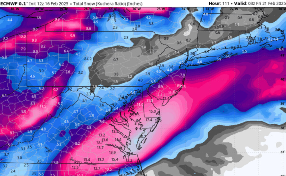
Not understanding the snow maps at all. DC squarely in 0.5”+ yet less than five inches of snow in a cold storm?
I mean I get that snow growth isn’t as good outside the banding but I don’t think globals are very capable of that sort of granularity.
06
12z
-
4 minutes ago, nycsnow said:
Eh
Image
Oy this is terrible. What a crazy let down last 24 hours
-
2
-
 1
1
-
-
17 minutes ago, NEG NAO said:
50 mile adjustment north and west = MECS in NYC metro --- lets see how many EPS members are 50 miles north and west of the OP
The problem is this is by far the most NW of all models. Others need a 150-200 mile shift
-
1
-
1
-
-
3 minutes ago, jayyy said:
Good thing this is the mid Atlantic forum then. Ya know, south of the Mason DixonThe map showing snow in PA and in New England is misleading. In reality almost all the snow there falls today so the storm for Thursday is still SE of the area. I’m hoping this trends NW as well but just pointing out the snow may includes totals to the north west and NE that are falling now
-
 1
1
-
-
2 minutes ago, mikem81 said:
Some snow is todays
I mean the snow in PA and NE
-
1 minute ago, CAPE said:
Latest Natty blend. Note there is zero indication of a miss to the SE. Not sure exactly why/how that has become a point of discussion.

Some snow is todays
-
5 minutes ago, psuhoffman said:
You would benefit from what I am talking about also. There are very few examples of DC getting crushed with a wave of this type and NYC missing out completely. The runs that were better for us were better for you also.
Thanks. What are we looking for over the next runs for clues on where this ends up? Is it really the position of the ULL that determines this
-
9 minutes ago, psuhoffman said:
hmmm, not dismissing this...but for the kicker to have that kind of impact...doesn't it need to impact the H5 which drives the flow? And in that case I should see other examples that looked like this and crushed just SE of us with snow but I don't. But the upper low still tracks to our NW and is plenty to the NW of the surface low not pressing it east...it's just weird to me. The weird part is to have a wave amplified enough to drop those kinds of snow totals down there...but not come north despite the flow being plenty relaxed enough and the confluence to be way up near Canada. That's why you don't see examples of this...for a wave to get "kicked" in that kind of flow it would have to be pretty weak, and a weak wave isn't dropping 1-2 feet of snow anywhere. A wave that is amplifying enough to put down that kind of snow wouldn't just turn east ahead of a cut off upper low back over Ohio and a SW to NE flow all the way to Maine with the 50/50 already to south of Greenland! Make it make sense.
Love your analysis and I check this forum from Long Island to see your posts. What are york thoughts for my area? You seems to think this will trend NW. what are we specifically looking for for the ULL and anything else the next few Runs?
-
31 minutes ago, coastalplainsnowman said:
lol
The sabbath. What can I do. Recommend everyone take 25 hours off at this point and check back after that period. It’s healthy
-
I feel like we saw the famous windshield wiper effect today between 0z and 12/18z with the western and eastern extremes. I’m assuming 0z will be somewhere in between at least for the Euro
-
1
-
-
2 minutes ago, Allsnow said:
EPS stays the same which is probably the only positive
keep in mind the eps never bought into the ops mega blizzard
Do you have the LP for the ensembles?
-
The 6Z EURO (literally from 12 hours ago) and 12Z UK look pretty darn good
-
Seems like the 0Z CMC and EURO and 12Z UKMET were actually crazy on the coast, like almost into NYC. Not sure a freak out is called for over the 18Z euro
-
1
-
-
I missed the last 24 hours of models. Can someone please give me a brief rundown of where we stand? Seems like 0Z runs were great and then today everything fell apart except for the GEFS trending better as everything else trended worse?
.png.c81265ca5e6fb9115e59bef1415ee0e4.png)
.png.4bd88191d66258d91702255a223373d1.png)

The Ledge Storm 19-20 Feb
in Mid Atlantic
Posted
If the euro comes 50 miles west I’d actually take the NAM seriously as they’ve teamed up in prior miller A setups to trounce the gfs but I’m doubtful