

Mowfishin
-
Posts
37 -
Joined
-
Last visited
Content Type
Profiles
Blogs
Forums
American Weather
Media Demo
Store
Gallery
Posts posted by Mowfishin
-
-
Right now being in Mcclellanville sc i feel like I may be in a sweet spot for snow.
Never thought I would say that
-
 1
1
-
-
Can someone explain the surge situation. I understand the wind driven portion fully but I don’t fully grasp the wall of water that is often referred to by people who witness it first hand. Does the low pressure actually lift an area of water up in the eye above mean sea level?
I feel stupid asking this I just don’t grasp fully when people say the surge is there of a cat 5 when the winds have fallen for more than 12 hours to a cat three (hypothetical statement)
-
 1
1
-
-
Posted on main thread but will probably be deleted. Google project pheonix 2.0. First 5 minutes are most interesting. Models out cat 5 into Tampa bay.
-
8 minutes ago, Greyhound said:
Seeing reports online that it hasn’t failed. What are you hearing?
.
-
2
-
 1
1
-
-
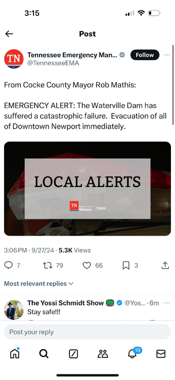
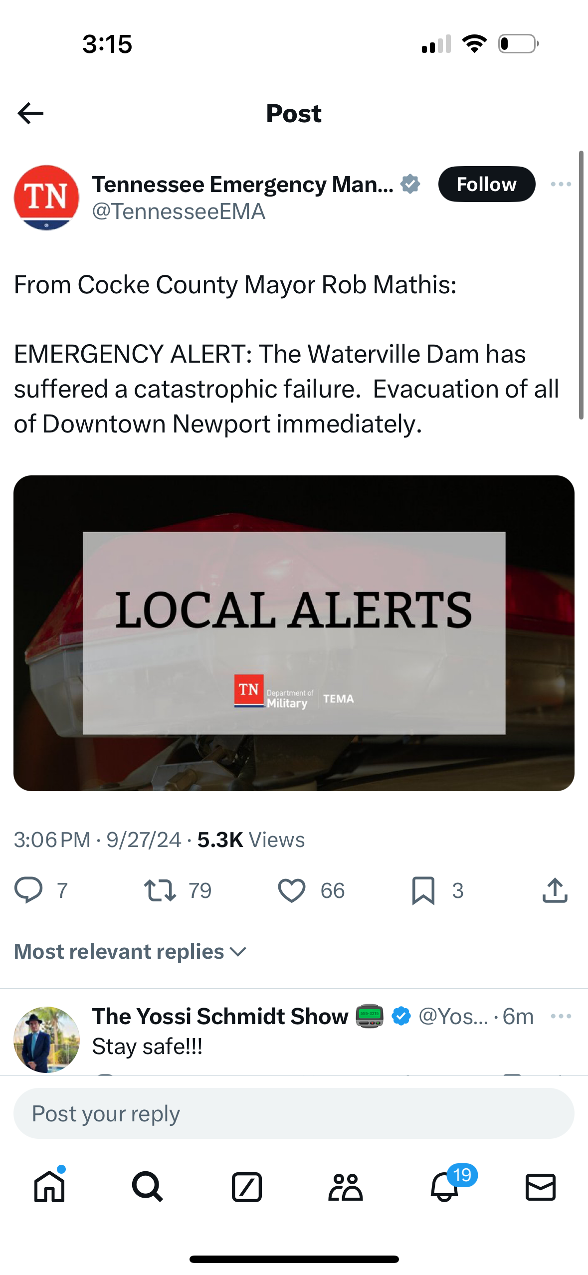
Listen to the scanner. Real time radio reporting catastrophic failure. Rescue vehicles being overtaken by water. Maybe it was major overtopping but they clearly said catastrophic failure
-
1
-
-
Cocke county if you have access to online scanner in real time
-
Multiple dam failures in TN. MAJOR FAILURE AT WATERVILLE LAKE. Listening on radio scanner
-
1
-
-
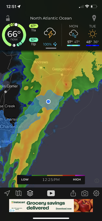
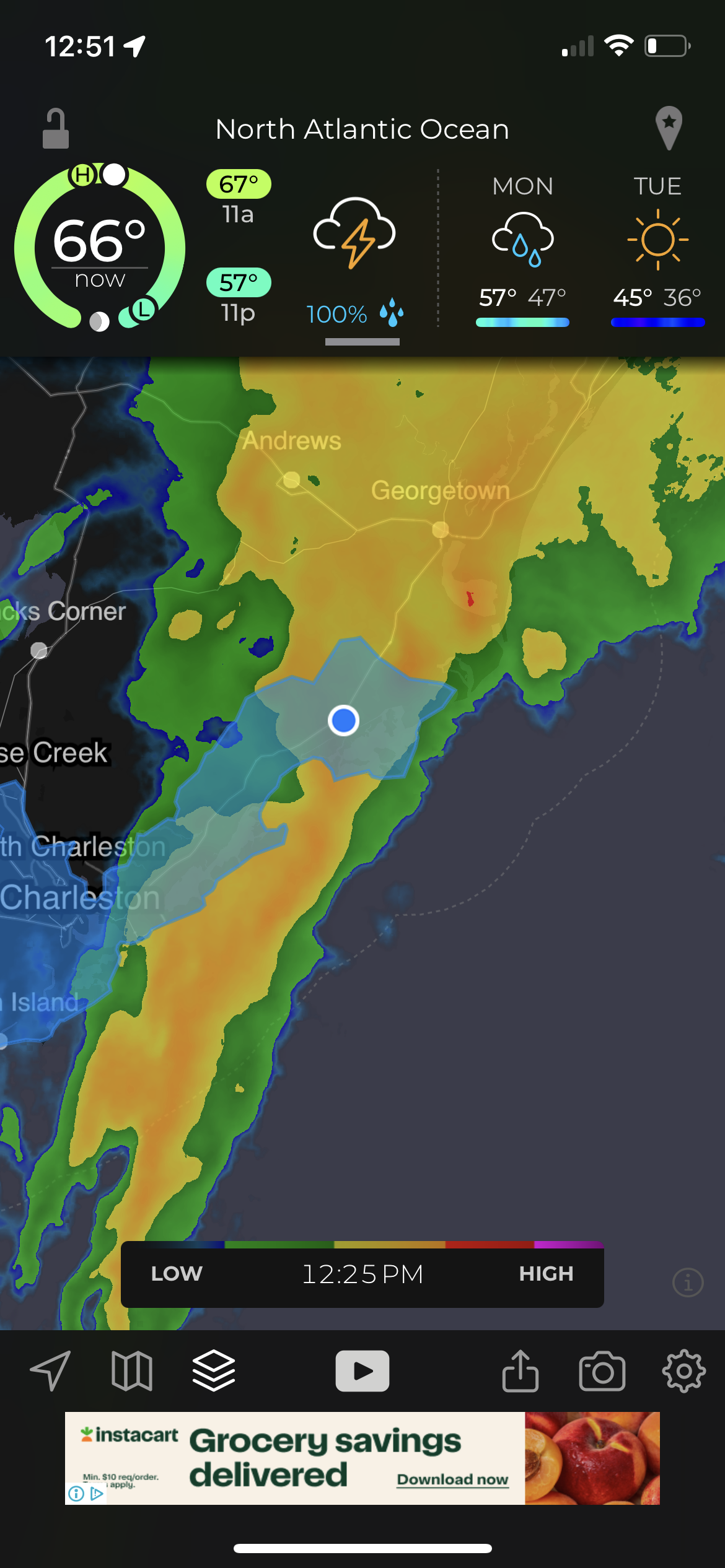
I posted in the wrong forum earlier. I live in Mcclellanville and we were under that trailing band most of the day. I ended up at 15.9” since 10:00 last night when it started. This was measured on an accurite digital rain gauge and other people in the area reporting around the same. Absolutely unreal. Very thankful high tide was at 11:45. Freshwater flooding has washed out a lot of the backroads. Almost zero wind from 9am on until now. Starting to get blustery so hoping no trees fall
-
1
-
 2
2
-
-
We are in that heavy band just north of Charleston. Currently sitting with 7.83 inches since last night. Also now at 7.85. Uploaded photos and now 7.96. Damn
-
1
-
-
Currently breezy with some gusts in the 40s. Big oak just took out power. 3” of rain
-
5 minutes ago, Jtm12180 said:
Did you live there in ‘89?
I was not. House was. Had water up 6' or so on the walls best I can tell from renovations I have been doing. With the recorded surge then, I'm not sure how it didn't cover the house.
-
I'm on ground level in Mcclellanville. I will try to post photos/updates. Plan on staying in neighbors house tomorrow. Looks like surge will move in around mid morning.
-
2
-
-
Based on current movement what are the chances this gets pushed out and never really come ashore?
-
1
-
-
I'm in McClellanville with a house on ground level on the creek. Certainly a little concerned at this point
-
1
-
-
1 minute ago, AnthonyEC said:
What’s the link?
https://tidesandcurrents.noaa.gov/stationhome.html?id=8725520
-
Fort myers gauge up to 8.33
-
1
-
1
-
-
I'm happy to announce I have seen sulphur butterflies appear around Charleston SC. They have always shown a significant pattern change is headed our way for cooler weather normally within a couple weeks of their arrival in strong numbers.
-
6
-
-
11 hours ago, Prospero said:
Oh the frustration of living in the year 2021 when global 3D radar is still yet to be developed. Maybe in ten years we'll watch live radar anywhere on the planet.
We will have global radar but the Hurricane Hunters will be flying the same planes with the same broken equipment.
-
 1
1
-
-
1 minute ago, Windspeed said:
Fred is trying. You can see where the LLC vorticity maximum is with the motion of light precipitation returns on the eastern side. Will that fill with strong convection into an eyewall?

We've been here before. That's just radar attenuation right!?!?
-
9 minutes ago, Windspeed said:
Pay close attention to the high cirrus flow, not the low and mid level clouds that are expanding west within the growing circulation. You will see that they are beginning to race poleward. That is due to the setup of the westward extension of 200 hPa upper heights over the E GOM. This should increase ventilation away and evacuate mass as Delta moves further WNW to NW this evening.
 7 minutes ago, Indystorm said:
The westward moving clouds off to the se of the storm are from the ne/easterly shear which has helped cause the weakening of the storm. Once Delta continues to move nw into the Gulf that shear will lessen as it rounds the base of high pressure in the eastern gulf and enable strengthening to occur once again.
Thanks!
-
1 minute ago, Windspeed said:
Delta's structure is improving considerably by the hour even with half of its circulation still over the Yucatán. Notice poleward upper level outflow increasing and significant expansion of an actual CDO. Delta looks primed to intensify once the core pulls away from the coast.

I am always trying to learn so please bear with me. In the right of that image it appears the cloud tops are being blown westward. Wouldn't a healthy vented system show outflow in this area as well? Is this what shear looks like?
-
6 minutes ago, brentrich said:
So there's a chance we will be seeing Cat 5 hurricane?
Ghost of Leroy hopes so and Turtle is sure of it.
-
13 minutes ago, hawkeye_wx said:
-
There is a chance you can see it come in on this cam...we will see HERE
1/21 - 1/22 Winter Storm Threat
in Southeastern States
Posted
Will this NW Trend lead to more mixing along the immediate coast? I’m in Mcclellanville sc and trying to manage my expectations