

Sportybx
-
Posts
174 -
Joined
-
Last visited
Content Type
Profiles
Blogs
Forums
American Weather
Media Demo
Store
Gallery
Posts posted by Sportybx
-
-
10 minutes ago, uofmiami said:
I can't get twitter links to post all of a sudden. Anyway:
Flash Flood Warning continues for Brooklyn NY, Queens NY and Hempstead NY until 2:45 PM EDT

I just got one in the bronx till 4pm
-
The fact that these models are flip flopping 5 days out . We won’t know till Friday . Exactly where he makes his turn will determine where he hits . Anything past 70 will be interesting . Anything before it’s mass or Canada area
-
 1
1
-
-
Lee was moving around 13 mph and all the models were showing a wnw to a nw track . Since it slowed to 8mph it’s now taking that left hook . Is it possible the change of speed is missing the ridge and that’s why we are getting the left hook ?
-
What would cause the Hurricane hunters not being able to fly through the eye wall last night , saying it was too dangerous?!?
-
 1
1
-
-
GFS with a wild hook into Ri/MA …. These next few days are going to be wild . If it don’t hit the wall and bounce straight north . The NJ up to MA coast should start getting ready
-
 2
2
-
1
-
2
-
-
16 minutes ago, Normandy said:
Anybody got any insight into why recons is doing multiple rapid fire passes like they are? I’m not objecting because hey more data the better but this is a bit unusual no?
Probably because they know something we don’t . Or they have no idea where it’s going and when the last 60seconds becomes reality. They will know how bad that area or areas will be
-
8 minutes ago, WxWatcher007 said:
Yeah not quite sure what to make of it. Every degree matters, especially since the trend has continued to be a more extended northward push. I don’t think this gets to 75W obviously…but some westward drift toward 70-71W could mean a greater chance of direct impacts in ENE/Atlantic Canada.
Was just watching a live meteorologist with live feed on Lee . they are saying the shear broke the backside off and now it isn’t moving Wnw anymore , it’s now moving due W . They weren’t expecting that to happen .
-
When is he suppose to be making this move north ?!?
-
1
-
-
In the area around NYC , where would landfall need to be for it to be to see hurricane conditions ?!?
-
3
-
-
Everything is still in play , so many pieces have to come together at the right time in order for this to be a fish storm .
this storm from Va to MA needs to be monitored over the next week . The storm is going to be Huge by the time it comes up north and a 50 mile shift to the west could end up being catastrophic to the coast with surge , wind , flooding ect-
2
-
1
-
-
4 minutes ago, Doorman said:
https://www.wpc.ncep.noaa.gov/discussions/hpcdiscussions.php?disc=qpfhsd
WPC disco
Probabilistic Heavy Snow and Icing Discussion
NWS Weather Prediction Center College Park MD
402 PM EDT Sun Mar 12 2023Valid 00Z Mon Mar 13 2023 - 00Z Thu Mar 16 2023
The heaviest snow will likely occur in the interior northeast
terrain including the Adirondacks, Catskills, Greens, Berkshires,
Worcester Hills, Monadnocks, and Whites where WPC probabilities
for 6 inches are above 80% on D2, and reach 50-80% for 12 inches
in these same areas. In the valleys, snow totals will likely be
less, but intense ascent could still prevent extreme shadowing on
the e/ne flow, and WPC probabilities for 6+ inches are above 50%
even in the lower elevations all the way up the coast of Maine
despite that area being impinged upon by drier air and being more
removed from the low center as it moves east instead of northeast
late. For the I-95 corridor, there is good potential for a period
of heavy snow to develop on the back side of the system near the
coastal front, and while WPC probabilities for NY to Boston are
pretty low for 2-4 inches, the guidance has trended a bit more
aggressively for this area, and there are several members in the
WSE plumes that suggest heavy accumulations even to the coast.
While confidence in major impacts and heavy snow accumulations is
greatest inland across the higher terrain, the potential still
exists for a significant snowstorm for NYC to Boston as well.THE DARTBOARD

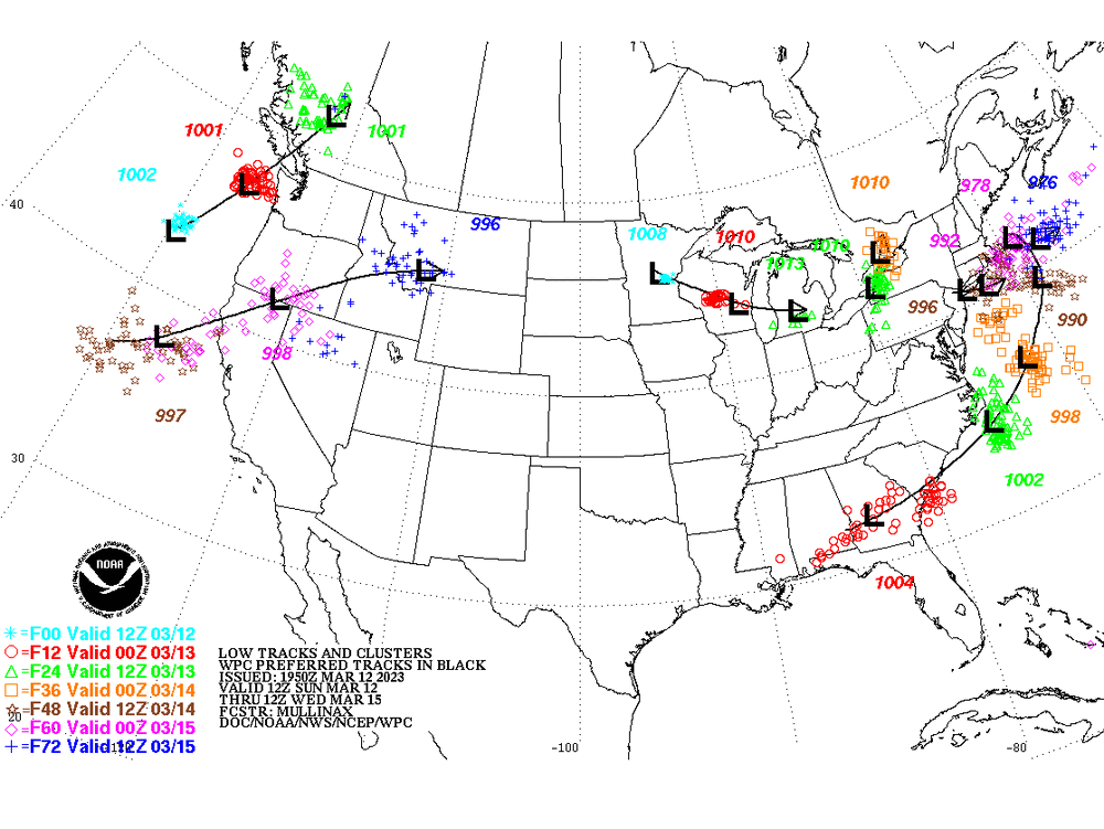
Basically they aren’t sure what’s going to happen yet . Everyone is still in for the possibility of a big storm but it’s wait and see !
-
1
-
-
Completely untrue. The mandatory evacuation orders went out yesterday.
Yeah for people on the coast or in zone A . When it was suppose to be a cat 2 maybe a 3 . No one in zone 3 or “C” was told to leave because the surge wouldn’t be as bad with a cat 2/3 storm .
This storm was Tampa / Panhandle up till yesterday . Not Naples , ft myers , Cape Coral .
By yesterday people from Tampa were driving south and east the roads were packed .
Not to mention the elderly who live in these areas .
The people along the coast or close to it . Yes stupid shouldn’t be there . The ones who were told this wouldn’t be “ that storm “ it isn’t on them at all .
. -
My parents are in Cape Coral right now , they were never told to leave , they weren’t evacuated. They are in zone 3 . Up till last night they were told it was only a high cat 2 maybe cat 3 that was going to hit Tampa , a lot of people stayed thinking it wouldn’t be that bad .
When you tell someone 4 hours before it hits its now a cat 5 . It’s to late .
That is on local , state and federal agencies.
I can’t even put blame on meteorologists because they are only right 8% of the time with anything .
.-
1
-
3
-
-
Captiva beach right into pine island and matlacha Florida , 142 mph with storm surge at 14 feet ..,,,!
. -
What are we looking at surge / wind for Cape Coral at this point ?
. -
What are we looking at for the impacts for Cape Coral Florida .
I have my mother and father down there . Father is in oxygen and both are thick headed and won’t listen to me when I told them to head over to the east coast .
. -
The worst part of this storm . Is going to be everyone who wasn’t prepared because no media coverage. Then tomorrow 2 hours before it hits everyone is running wild for supples
-
2
-
 1
1
-
2
-
-
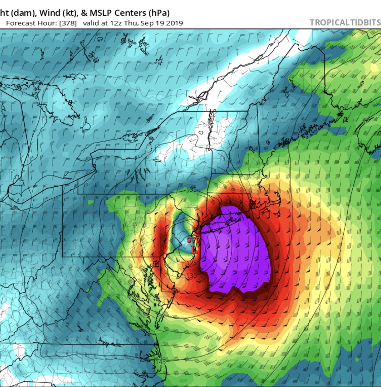
The Ukie has been consistent with those models .
-
24 minutes ago, nycsnow said:
Upton has me in southern brooklyn gusting to 70... do you see that as well on soundings?
That’s with the current track . If this happened to get stronger ( with everything it went through ) I can see it happening . Can we see hurricane gusts here in the tri State area ? I believe we are also in MOON tide , any significant coastal flooding you think .
-
1
-
-
What are we looking at worst case scenario if it stays East for NYC area .
-
Let’s say it’s somewhere between the Euro and the Ukie . What are we looking at for the Tri State area , flooding , winds beach erosion ? Are we looking at big storm surge
-
Given the current track . How is it looking for NYC . Are we talking flooding or just some wind and heavy rain . With LI getting all the flooding ?
-
34 minutes ago, cptcatz said:
The worst possible track a hurricane can take?

Why would this be the worst possible track and not one slamming into the Jersey sure say ?
-

Another big Sept rain event between roughly midnight Friday morning and midnight Sunday morning (bulk 9/29-30/2023)
in New York City Metro
Posted
When is this suppose to be officially over ?!?