

NERMAN
-
Posts
15 -
Joined
-
Last visited
Content Type
Profiles
Blogs
Forums
American Weather
Media Demo
Store
Gallery
Posts posted by NERMAN
-
-
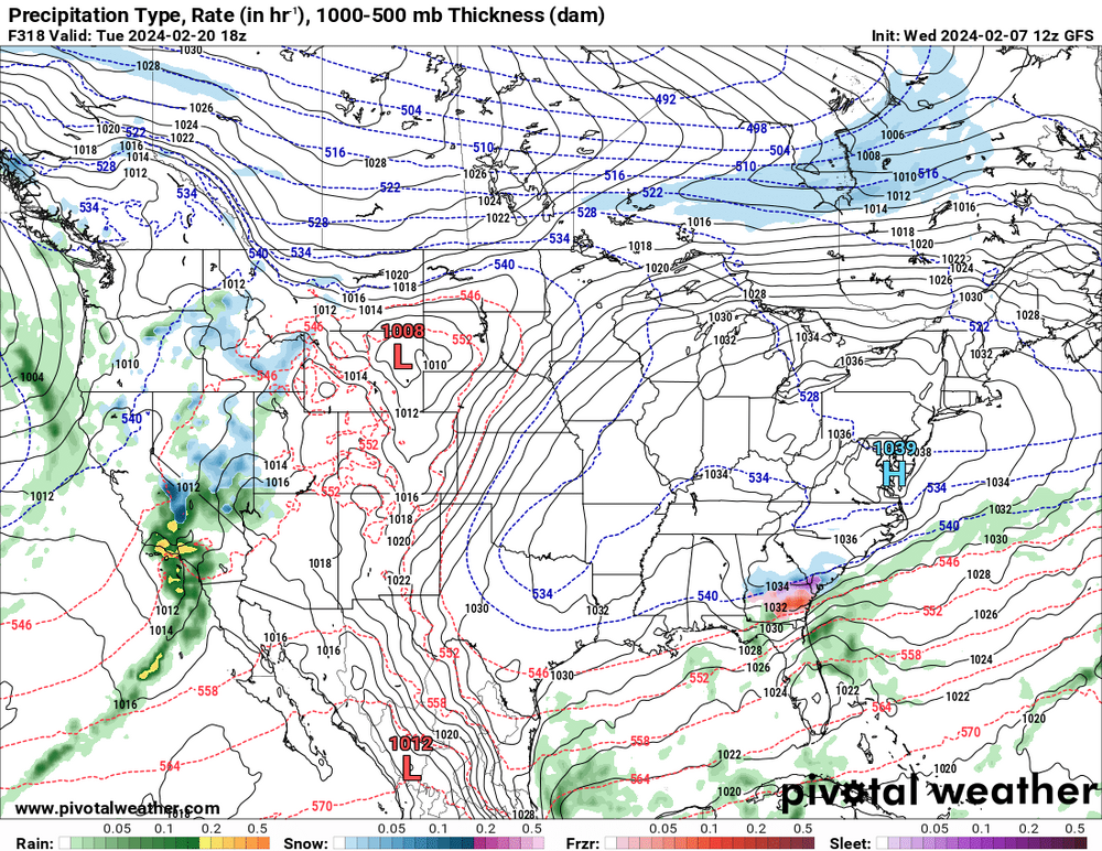
GFS has been showing this fantasy land snow way South for several runs now. Shows the potential for the upcoming period.
-
 1
1
-
-
OZ Euro showed much more favorable conditions during this time frame. Waiting to see what it does at 12z. CMC was more favorable too.
-
1
-
-
4 minutes ago, Nibor said:
The hurricane models hwrf hmon hafs a/b all really show deepening this afternoon. I think the forecast is on track.
Yep, all showing Big Bend landfall. Euro caved to the west. I'd like to know which intensity models aren't showing this strength to compare.
-
3 minutes ago, CoastalWx said:
A lot of the intensity models haven't strayed from strong 2 borderline 3.
HWRF, HMON and HAFS all still showing a strong Cat 3 to weak Cat 4 as of 6z. They've been rock-steady.
-
28 minutes ago, WxWatcher007 said:
Recon is in the air and will soon provide critical structural and heading data on a strengthening Hurricane Idalia.
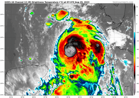
Idalia has remained resilient in the face of moderate shear the last few days, gradually organizing and attempting to fire convection consistent enough to establish an inner core. This morning satellite and radar show that with shear decreasing Idalia is beginning to develop an inner core, with deep convection rotating around the center in the image above and an eye feature evident on radar.
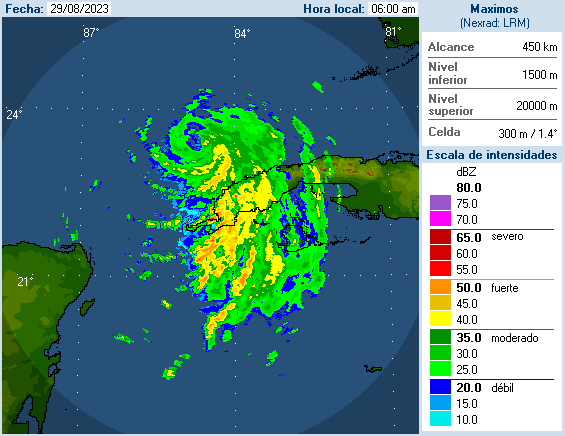
Recon will be important in assessing just how far along this inner core process has progressed, and whether there is still significant vortex tilting, which can still be possible if there's enough shear still present. My guess looking at the radar however, is that the vortex tilting that was an issue 24 hours ago is no longer enough to keep this from increasing its rate of intensification.
According to CMISS analysis, shear is now in the favorable zone and expected to remain so until landfall.


As the trough sets up during Idalia's final approach, upper diffluence combined with increasing OHC and SSTs will almost certainly allow for rapid intensification.


(SST image courtesy of Brian McNoldy)Once rapid intensification occurs, and it is explicitly forecast by the NHC, we don't know where it'll stop. Time will be a limiting factor, but it cuts both ways. On on hand, there may not be enough time for the very high ceiling for Idalia to be reached. On the other, the lack of time means that a structural change, such as an Eyewall Replacement Cycle (ERC) is less likely.
There is also modest but meaningful divergence in track.


The consensus among most guidance is to bring this further north, while the European Model and stronger members of the EPS have a further east landfall. It's been talked about around here but we will need to watch for deviations closely, as there are almost always small changes that have a substantial impact on sensible weather.
To be clear--nobody living in the region should merely look at the center track. Heavy rain, storm surge, and strong to destructive winds will be possible far outside the center. Given the parallel run up the west coast of Florida however, where the center landfalls is obviously important for surge and strongest wind impacts. The 06z GFS ticked ever so slightly east relative to 00z.
Watch the organizational trends, pace of intensification, and the wobbles relative to long term heading.
It should be an active day.
Great write-up. I've been comparing this storm to Michael and there are a lot of similarities in the conditions, path, profile and current status. If it can get to a Cat 2 quickly then it would have more time than Michael needed to make a run at Cat 5. I know it's HIGHLY UNLIKELY because that was a perfect scenario, and I'm not doomcasting or wishing, just throwing it out there the real possibility of intense RI over the next 24 hours.
-
1 hour ago, TriPol said:
I'd wager a hefty sum that the likelihood of a landfall event in the Florida Panhandle is rather minimal, a hypothesis that I find somewhat at odds with the current projections from the National Hurricane Center. Since the case of Hurricane Charlie, Gulf-originating hurricanes to veer westward in their tracks, particularly when their initial trajectories are not aimed at Texas, Louisiana, or the Mississippi/Alabama coastline. This westward bias is often less pronounced when a robust anticyclonic system is situated over Florida, effectively serving as a protective barrier for the state's western coastline. One could argue that the NHC's forecasting methodology could benefit from a reevaluation of these recurrent patterns, especially in the context of recent advancements in ensemble forecasting and data assimilation techniques.
I'm not quite sure I follow you? Are you suggesting the current NHC cone area for landfall (say cedar key to big bend) is unlikely to play out?
-
14 minutes ago, CheeselandSkies said:
May not be much on the immediate coast but some of the hurricane model solutions would put the western eyewall over Tallahassee; with how fast this thing is going to be trucking inland I'd expect they would get a lot more wind than during Michael if those verified.
Correct me if I'm wrong but doesn't the GFS show this too?
-
1
-
-
4 minutes ago, CheeselandSkies said:
I would wager 931 MB on the HWRF and 926 MB on the HAFS-B (both FH051) are not "strong Cat 3 to low-end Cat 4" verbatim.
BTW, is there any other way to pronounce the new hurricane model besides "half-ass"? I can't think of one.

HMON and HAFS-A are both in the mid 950's. Splitting the difference with the two you mentioned gets a strong cat 3 to low-end cat 4.
-
10 minutes ago, Prospero said:
Last year on the morning Ian hit Florida Tampa Bay was in the center of the cone. Folks in Sanibel Island and Ft. Myers were relaxing thinking it was going to miss them to the west.
Yep, they should have evacuated all of those low lying areas in advance. The loss of life particularly in Ft Myers could have been avoided. But I also remember reading a lot of the locals refused to leave. I mean, they had a major tracking toward them for days. https://www.nhc.noaa.gov/archive/2022/IAN_graphics.php?product=5day_cone_no_line_and_wind
-
1
-
-
Hurricane models held landfall intensity at 12Z from strong Cat 3 to low-end Cat 4 tracking toward Big Bend
-
12z GFS came in with the same intensity as 06z, as a Cat 3
-
10 minutes ago, CheeselandSkies said:
I prefer to wait for the actual frame-by-frame model runs of the hurricane models (HAFS-A/B, HWRF, HMON) with MSLP, sim IR, etc.
Totally agree. HWRF showed a strong Cat 4 at 06z and the others had a strong Cat 3. Let's see what they have at 12z before saying the guidance has dropped.
-
3
-

Mid to Long Range Discussion ~ 2024
in Southeastern States
Posted
Does this work for you? It's still not worth relying on.