

dizzy9479
-
Posts
113 -
Joined
-
Last visited
Content Type
Profiles
Blogs
Forums
American Weather
Media Demo
Store
Gallery
Posts posted by dizzy9479
-
-
Light sleet in Williamstown, NJ - good for you to the north!
-
58 minutes ago, zenmsav6810 said:
Except there's no such thing as a snow day- rather the kids have to telecommute for their flexible instruction day like mini-adults on their laptops! Communicable illness and the fact their is more fast moving traffic on the roads today also weighs more heavily on the decision making these days.
In New Jersey, students are not permitted to have virtual snow days in public schools. During the pandemic, a law was passed that the only circumstances under which a school can go virtual is for health reasons.
-
First flakes in Williamstown, NJ around 5:40 AM - dusting immediately.
-
 1
1
-
-
Could this emerge south of Cuba and pick up strength again?
-
Up to 30/70 at 8 PM.
A broad area of low pressure located over the southwestern Gulf of
Mexico is producing disorganized showers and thunderstorms.
Gradual development of this system is expected, and a tropical or
subtropical depression or storm is likely to form late this weekend
or early next week while the system moves eastward or northeastward
across the Gulf of Mexico.  Interests in the Florida Peninsula and
the Florida Keys should monitor the progress of this system.
Regardless of tropical or subtropical development, locally heavy
rains could occur over portions of Mexico during the next day or
two, and over much of Florida late this weekend through the middle
of next week.
* Formation chance through 48 hours...low...30 percent.
* Formation chance through 7 days...high...70 percent.
-
5 hours ago, Seminole said:
Filled out a missing person report for my son in Ashville, NC. I last heard from him Friday at 1:30 PM. He said he was on the second floor of his home and cut off from everything because of flood water and debris. The situation there is beyond dire.
So sorry to hear this - sending thoughts and prayers your way.
-
 1
1
-
 1
1
-
-
140 it is:
000
WTNT42 KNHC 301445
TCDAT2

Hurricane Beryl Discussion Number   8
NWS National Hurricane Center Miami FL       AL022024
1100 AM AST Sun Jun 30 2024

Data from the Air Force and NOAA Hurricane Hunters this morning
indicate that Beryl continues to rapidly intensify.  Based on the
data collected, the minimum pressure has fallen significantly to
964 mb and the maximum wind speed is now up to 105 kt.  Although
Beryl is still on the small side, the wind field is a little larger
than previously noted with the tropical-storm-force winds estimated
to extend up to 100 n mi from the center and hurricane-force winds
up to 25 n mi from the eye.  Satellite images show that Beryl has a
classic major hurricane pattern with a clear and circular eye and
symmetric convective pattern surrounding it.

Beryl continues to move swiftly westward at 18 kt steered by a
strong subtropical ridge to its north.  The hurricane has been
moving a little to the south of most of the model predictions over
the past day or two.  A continued quick west to west-northwest
motion is forecast during the next several days as the ridge remains
the primary steering feature.  This should take the core of Beryl
across the Windward Islands Monday morning and then across much the
Caribbean Sea during the following few days.  The NHC track forecast
has been nudged to the south of the previous prediction and lies
close to the various consensus aids.

The major hurricane has rapidly intensified since it formed a
couple of days ago, and given the continued conducive environmental
conditions and compact inner core, it will likely strengthen some
more through tonight.  Beryl is expected to be a very dangerous
category 4 hurricane when it moves through Windward Islands.  The
models show a gradual increase in shear when the system moves
across the Caribbean Sea and that should cause Beryl's intensity to
level off and then gradually weaken.  However, Beryl is expected to
remain a significant hurricane through the next 5 days.  The
intensity forecast is a little above the previous one and in good
agreement with the HCCA and IVCN models.


Key Messages:

1. Beryl is expected to be an extremely dangerous Category 4
hurricane when it reaches the Windward Islands. This is a very
dangerous situation and residents in these areas should listen to
local government and emergency management officials for any
preparedness and/or evacuation orders. All preparations should be
rushed to completion today.

2. Potentially catastrophic hurricane-force winds, a
life-threatening storm surge, and damaging waves are expected
when Beryl passes over portions of the Windward Islands with the
highest risk of the core in St. Vincent and the Grenadines, and
Grenada beginning early Monday morning.  Hurricane Warnings are in
effect for much of the Windward Islands.

3. Heavy rainfall and localized flooding are expected across the
Windward Islands through Monday.

4. Beryl is expected to remain a powerful hurricane as it moves
across the Caribbean Sea later this week and interests in
Hispaniola, Jamaica, the Cayman Islands and the remainder of the
northwestern Caribbean should monitor its progress, There is large
forecast uncertainty  at days 4 and 5 and users should not focus on
the specific details of the track or intensity forecast.


FORECAST POSITIONS AND MAX WINDS

INIT  30/1500Z 10.7N  54.9W  105 KT 120 MPH
 12H  01/0000Z 11.2N  57.5W  120 KT 140 MPH
 24H  01/1200Z 12.1N  60.9W  120 KT 140 MPH
 36H  02/0000Z 13.3N  64.3W  115 KT 130 MPH
 48H  02/1200Z 14.6N  68.2W  115 KT 130 MPH
 60H  03/0000Z 15.6N  72.1W  110 KT 125 MPH
 72H  03/1200Z 16.4N  75.9W  105 KT 120 MPH
 96H  04/1200Z 17.8N  82.8W   95 KT 110 MPH
120H  05/1200Z 19.2N  88.3W   75 KT  85 MPH...INLAND

$$
Forecaster Cangialosi
-
1
-
-
Exceptionally small flakes flying in Williamstown, NJ also. Hoping for 3 inches but that's probably overly optimistic
-
1
-
-
Tropical Storm Fred Tropical Cyclone Update
NWS National Hurricane Center Miami FL       AL062021
215 PM CDT Mon Aug 16 2021

...FRED MAKES LANDFALL IN THE EASTERN FLORIDA PANHANDLE...

National Weather Service WSR-88D radar data indicate that the
center of Tropical Storm Fred has made landfall near Cape San
Blas, Florida.  Maximum sustained winds are estimated to be near
65 mph (100 km/h).

SUMMARY OF 215 PM CDT...1915 UTC...INFORMATION
----------------------------------------------
LOCATION...29.7N 85.4W
ABOUT 25 MI...40 KM W OF APALACHICOLA FLORIDA
MAXIMUM SUSTAINED WINDS...65 MPH...100 KM/H
PRESENT MOVEMENT...NNE OR 20 DEGREES AT 9 MPH...15 KM/H
MINIMUM CENTRAL PRESSURE...994 MB...29.35 INCHES

$$
Forecaster Pasch/Hagen
-
1 minute ago, Wannabehippie said:
I can't believe he chased a TS. He must have the itch real bad.
He is working the storm for WeatherNation - his Twitter notes that was why he's chasing, haha
-
 4
4
-
-
Josh is in Port St. Joe - his twitter shows heavy rain but almost no wind at all coming in.
-
11 minutes ago, Prospero said:
Welcome to Pinellas County, FL! Enjoy your stay! The best to place to be (or NOT to be) for Elsa.
If the power is on tomorrow, we have great food and fun down here!
Come visit Gulfport, not too far and BayNews9 is already here because our cool little town floods in every storm. Not a good thing, but we are kind if used to it.
")
Admittedly a bit jealous. Being from southern New Jersey, we don't get this kind of weather often. I'll be in Gulfport for work next week at this time - a week too late, haha. Hoping you all experience minimal disruption and damage but get to see some nice gusts!
-
1
-
-
1 minute ago, MKSOZZ3069 said:
starting as sleet in shamong nj
Just noticed that we have pingers here in Williamstown, NJ also
-
4 minutes ago, Hurricane Agnes said:
Looking at Sterling and there were reports of 3/4" sleet in WV. Wonder if BLT is getting graupel or rimmed flakes.
BWI reporting FZRA now......
-
-FZRA started here in Williamstown, NJ - central Gloucester county. 30.6 F
-
Flipped here in Williamstown, NJ about 30 minutes ago - coming down like crazy and roads starting to cover on the sides. 33.3 F
-
Thanks for doing this -- slight revision though for PHL -- we had 5 days of 90+ in June, so 20 total so far: 6/1 -- 90, 6/11 -- 92, 6/12 -- 90, 6/19 -- 91, 6/20 -- 91. Thanks!
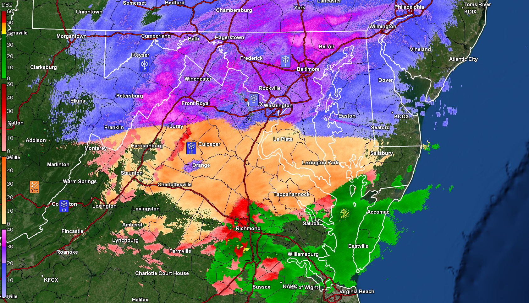
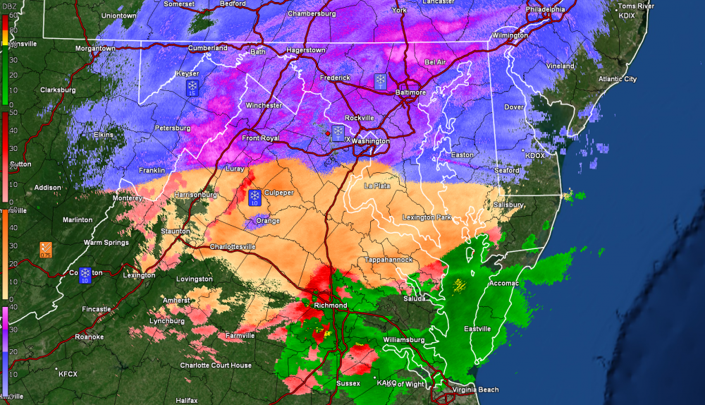
February 15-16 Slop Fest/Rain/Wind OBS
in Philadelphia Region
Posted
Williamstown, NJ - still white rain for the most part and 34F