

Mordecai
-
Posts
365 -
Joined
-
Last visited
Content Type
Profiles
Blogs
Forums
American Weather
Media Demo
Store
Gallery
Posts posted by Mordecai
-
-
5 minutes ago, NorthArlington101 said:
<snip>
Wow, appears you got a local jackpot. Roads here never caved, just cars, grass, and a bit of the driveway.
-
 1
1
-
-
2 minutes ago, Terpeast said:
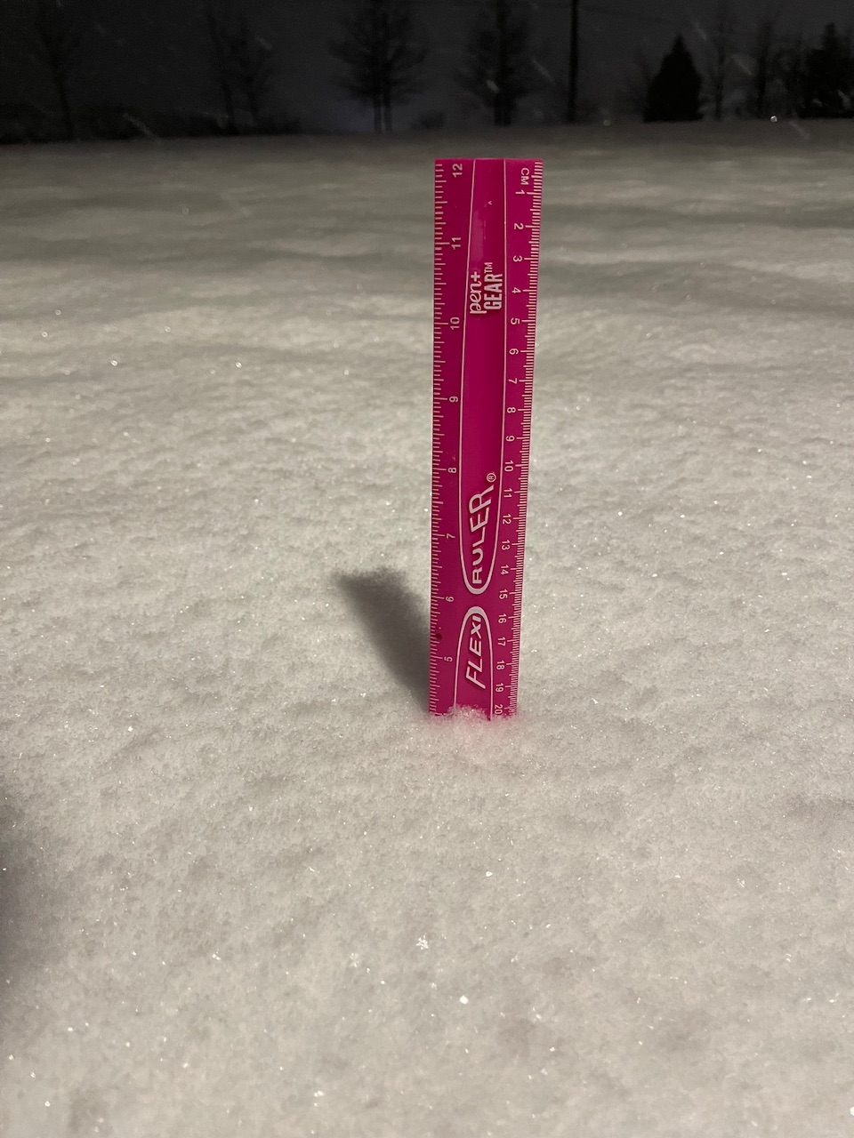
1.5” and snowing. 32/31.8
Slant stick measurement?
-
Dulles Airport reported 0.3" as of 01:00.
-
12/11/23: 0.4"
1/15-1/16/24: 4.5"
1/19: 5.0"
2/13: 0.5"
Total: 10.4"
-
Grass, cars, and rooftops have caved but roads are just slushy right now. Don't think I'll reach an inch
-
Dumping snow
-

Any takers?

-
12/11/23: 0.4"
1/15-1/16/24: 4.5"
1/19: 5.0"
Total: 9.9"
-
15 minutes ago, pazzo83 said:
uh there's a plane on the Loudoun County Pkwy
Holy crap that's crazy. I know exactly where that is. To think I take that road everyday...
-
3 minutes ago, Terpeast said:
Wow, that’s close to me. I should go out and measure to confirm
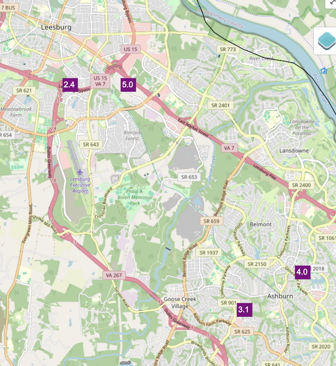
Seems like theyre just off rt 7
-
1 minute ago, Deck Pic said:
29/28, -SN
Here’s the 12z GFS 8 years ago today. We probably won’t hit these totals.
.has it really been that long? wow..
-
1
-
-
Snow started up again after a bit of a lull. Think we can beat last storm’s totals still
-
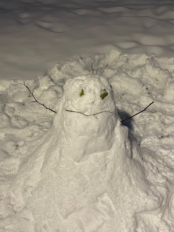
My snowman is reacting to the rainstorm going on in Georgetown.
-
1
-
 3
3
-
-
This is gonna outperform the storm earlier this week easily at this rate
-
1
-
 1
1
-
-
2 minutes ago, jayyy said:
Glad I decided to stay at my brother’s house tonight. I got off work late in Columbia and was scheduled to turn around and be there at 630am, so I decided to stay in Ellicott City to save myself 90 mins of driving to and from union bridge. May have been a good move snow wise with these last min developments.yeah and not exactly the best of conditions to drive in this AM
-
1
-
-

They also upped their totals!
lol ninja’d
-
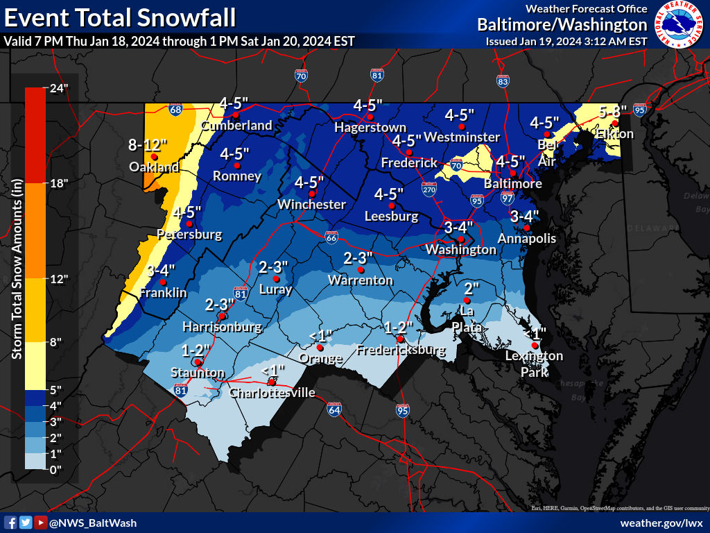
URGENT - WINTER WEATHER MESSAGE
National Weather Service Baltimore MD/Washington DC
328 AM EST Fri Jan 19 2024

MDZ004>006-008-011-507-508-191630-
/O.UPG.KLWX.WW.Y.0009.240119T0900Z-240120T0600Z/
/O.EXB.KLWX.WS.W.0005.240119T0900Z-240120T0300Z/
Frederick MD-Carroll-Northern Baltimore-Cecil-Southern Baltimore-
Northwest Harford-Southeast Harford-
328 AM EST Fri Jan 19 2024

...WINTER STORM WARNING IN EFFECT UNTIL 10 PM EST THIS EVENING...

* WHAT...Heavy snow expected. Total snow accumulations of 4 to 6
  inches.

* WHERE...Portions of north central, northeast and northern
  Maryland.

* WHEN...Until 10 PM EST this evening.

* IMPACTS...Plan on slippery road conditions. The hazardous
  conditions could impact the morning or evening commute.

PRECAUTIONARY/PREPAREDNESS ACTIONS...

If you must travel, keep an extra flashlight, food, and water in
your vehicle in case of an emergency.

When venturing outside, watch your first few steps taken on
steps, sidewalks, and driveways, which could be icy and slippery,
increasing your risk of a fall and injury.
-
1
-
-
Driveways, sidewalks, and car tops have caved already. Radar looks great
-
1
-
-
NAM’d
-
2
-
-
Light snow just started. 30F
-
1
-
-

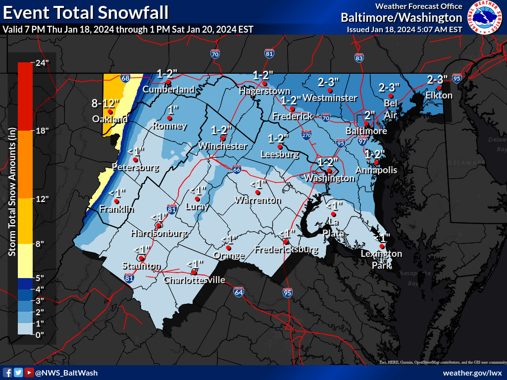
NWS updated their totals this morning
-
1
-
-
8F here. Looks like the snow pack is here to stay for a bit, especially if the Friday storm verifies.
-
12/11/23: 0.4"
1/15-1/16/24: 4.5"
Total: 4.9"
-

4” here around an hour ago! Had a nice jebwalk
-
2
-

Mid-Atlantic Snow Totals Thread - Winter 2023-2024
in Mid Atlantic
Posted
12/11/23: 0.4"
1/15-1/16/24: 4.5"
1/19: 5.0"
2/13: 0.5"
2/17: 1.1"
Total: 11.5"