

EB89
-
Posts
219 -
Joined
-
Last visited
Content Type
Profiles
Blogs
Forums
American Weather
Media Demo
Store
Gallery
Posts posted by EB89
-
-
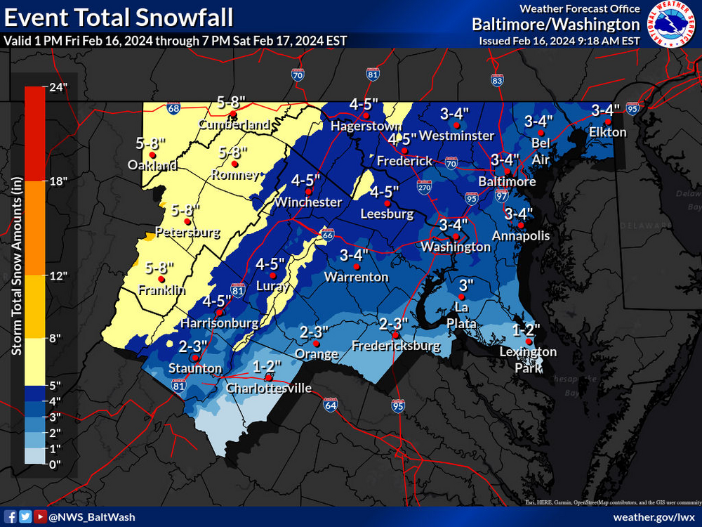
Hazardous Weather Outlook
Hazardous Weather Outlook
National Weather Service Baltimore MD/Washington DC
938 AM EST Fri Feb 16 2024

MDZ003>006-503-505-507-VAZ025>031-036>040-050-051-501-502-505>508-
526-WVZ050>053-055-171445-
Washington-Frederick MD-Carroll-Northern Baltimore-
Northwest Montgomery-Northwest Howard-Northwest Harford-Augusta-
Rockingham-Shenandoah-Frederick VA-Page-Warren-Clarke-Nelson-
Albemarle-Greene-Madison-Rappahannock-Orange-Culpeper-
Northern Fauquier-Southern Fauquier-Western Loudoun-
Eastern Loudoun-Northern Virginia Blue Ridge-
Central Virginia Blue Ridge-Northwest Prince William-Hampshire-
Morgan-Berkeley-Jefferson-Hardy-
938 AM EST Fri Feb 16 2024

This Hazardous Weather Outlook is for portions of eastern West
Virginia, northern and central Virginia, and central and western
Maryland.

.DAY ONE...Today and Tonight

Winter Storm Warning and Winter Weather Advisories are in effect
for tonight.

.DAYS TWO THROUGH SEVEN...Saturday through Thursday

The winter weather headlines continue through early Saturday.

.SPOTTER INFORMATION STATEMENT...

Spotters should be prepared to report snowfall measurements and
observations of heavy snowfall rates.
-
Don’t know if this was posted yet.
-
 7
7
-
 1
1
-
-
WASHINGTON-FREDERICK MD-CARROLL-NORTHERN BALTIMORE-CECIL-
CENTRAL AND EASTERN ALLEGANY-NORTHWEST MONTGOMERY-
NORTHWEST HOWARD-NORTHWEST HARFORD-AUGUSTA-ROCKINGHAM-SHENANDOAH-
FREDERICK VA-PAGE-WARREN-CLARKE-RAPPAHANNOCK-NORTHERN FAUQUIER-
WESTERN LOUDOUN-EASTERN LOUDOUN-CENTRAL VIRGINIA BLUE RIDGE-
NORTHWEST PRINCE WILLIAM-MORGAN-BERKELEY-JEFFERSON-
600 PM EST THU FEB 15 2024
...WINTER STORM WATCH IN EFFECT FROM FRIDAY EVENING THROUGH
SATURDAY MORNING...
* WHAT...HEAVY SNOW POSSIBLE. TOTAL SNOW ACCUMULATIONS OF 2 TO 4
INCHES ARE MOST LIKELY, WITH THE POTENTIAL FOR LOCALIZED TOTALS OF
UP TO 6 INCHES UNDER HEAVIER SNOW BANDS.
* WHERE...PORTIONS OF CENTRAL, NORTHERN, AND WESTERN MARYLAND,
NORTHERN AND NORTHWESTERN VIRGINIA, AND EASTERN WEST VIRGINIA.
* WHEN...FROM FRIDAY EVENING THROUGH SATURDAY MORNING. THE STEADIEST
SNOW IS MOST LIKELY FROM LATE FRIDAY EVENING THROUGH THE PRE-DAWN
HOURS EARLY SATURDAY MORNING.
* IMPACTS...PLAN ON SLIPPERY ROAD CONDITIONS. THE HAZARDOUS
CONDITIONS COULD IMPACT THE FRIDAY EVENING COMMUTE WEST OF
INTERSTATE 81.
* ADDITIONAL DETAILS...SNOWFALL RATES OF 1 TO 2 INCHES PER HOUR ARE
POSSIBLE FOR A FEW HOURS OVERNIGHT FRIDAY NIGHT UNDER THE HEAVIEST
SNOW BANDS. VISIBILITY MAY BE REDUCED TO LESS THAN ONE HALF MILE
AT TIMES.
PRECAUTIONARY/PREPAREDNESS ACTIONS...
MONITOR THE LATEST FORECASTS FOR UPDATES ON THIS SITUATION
-
3 minutes ago, Solution Man said:
Getting to the point of not flying after 3 hours.
Finally de-icing.
-
Just now, Solution Man said:
Hope you’re in first class
SWA
-
10 minutes ago, Eskimo Joe said:
Ground stop at DCA.
Been sitting on a plane for 3 hours now.
-
Loudoun government closed.
-
1
-
-
Drive from Frederick to DCA was fun. Roads caved quickly. Hoping flight stays on time.
-
Frederick MD schools closed tomorrow.
-
Frederick County Md schools closed tomorrow.
-
What is the chance my 6am flight out of DCA is impacted?
-
URGENT - WINTER WEATHER MESSAGE
National Weather Service Baltimore MD/Washington DC
826 AM EST Thu Jan 18 2024

MDZ004>006-008-011-507-508-182130-
/O.NEW.KLWX.WW.Y.0009.240119T0900Z-240120T0600Z/
Frederick MD-Carroll-Northern Baltimore-Cecil-Southern Baltimore-
Northwest Harford-Southeast Harford-
826 AM EST Thu Jan 18 2024

...WINTER WEATHER ADVISORY IN EFFECT FROM 4 AM FRIDAY TO 1 AM EST
SATURDAY...

* WHAT...Snow expected. Total snow accumulations of 2 to 4
  inches.

* WHERE...Portions of north central, northeast and northern
  Maryland.

* WHEN...From 4 AM Friday to 1 AM EST Saturday.

* IMPACTS...Plan on slippery road conditions. The hazardous
  conditions will impact the morning commute.

PRECAUTIONARY/PREPAREDNESS ACTIONS...

Slow down and use caution while traveling.

When venturing outside, watch your first few steps taken on
steps, sidewalks, and driveways, which could be icy and slippery,
increasing your risk of a fall and injury.
-
2 minutes ago, Bob Chill said:
Pre-dawn Friday as it stands now.
Thanks. Have a 6:05 flight out of DCA so hoping for no delays getting out of town.
-
What’s the potential start time looking like at DCA?
-
-
Snow picking up again and flake size increasing.
-
1
-
-
Very fine flakes here in Frederick.
-
1
-
-
This band in Frederick means business
-
1
-
-
3 minutes ago, MillvilleWx said:
3-6” is a solid bar right now. We are over 2” currently and the good stuff is really just starting. NAM has been steady 4.5-6” for several runs. Sounds right for what’s transpiring. You in North FDK?
Sounds good to me. Yeah, right on the other side of the Rt. 15 bridge. North crossing/willowbrook near the sheetz.
-
1 minute ago, MillvilleWx said:
Was noticing this as well. The evolution is going as expected from what has been depicted by most guidance. Should see some 5-7” totals out of this one at this rate. Combo of 85H frontogen coupled with the mid-level ascent pattern should yield periods of 0.75-1.5”/hr rates for a time overnight into the early morning hrs.
Where do you feel like we end up? Just down the road from you.
-
I have a flight at 6 am the 20th from DCA so bank on the GFS.
-
Seems like mostly snow in Frederick now.
-
4
-
-
Just started in Frederick. Mostly sleet
-
2 minutes ago, Mrs.J said:
Snow has switched to sleet here.
snow sleet further north in Frederick.
-
1
-


The Weekend Rule? Saturday 2/17 - The Icon Storm
in Mid Atlantic
Posted