

Warm Nose
-
Posts
711 -
Joined
-
Last visited
Content Type
Profiles
Blogs
Forums
American Weather
Media Demo
Store
Gallery
Posts posted by Warm Nose
-
-
Roughly 2 inches, which makes it not a complete bust-o-rama. It was still fun. If there's a next one, great, if not at least we saw more snow this year here than I did last.
-
 1
1
-
-
3 minutes ago, Ji said:
What a dumb hobby. Never ignore the least snowy models

no way in hell that's even verifying here
-
Rates here are good but not spectacular. Nowhere near enough to overcome the pavement. With the looks of things I think I'll be lucky to get 2", more likely about and inch and a half which will bust way lower than the 5-8 LWX has. Not a big deal but the speed of this and lower QPF ended up getting us here. Trends mean something and just like Monday, it's gonna bust low.
On to the next, if there is one.
-
Meso discussion from SPC, would seem to support there's issue with drier air.
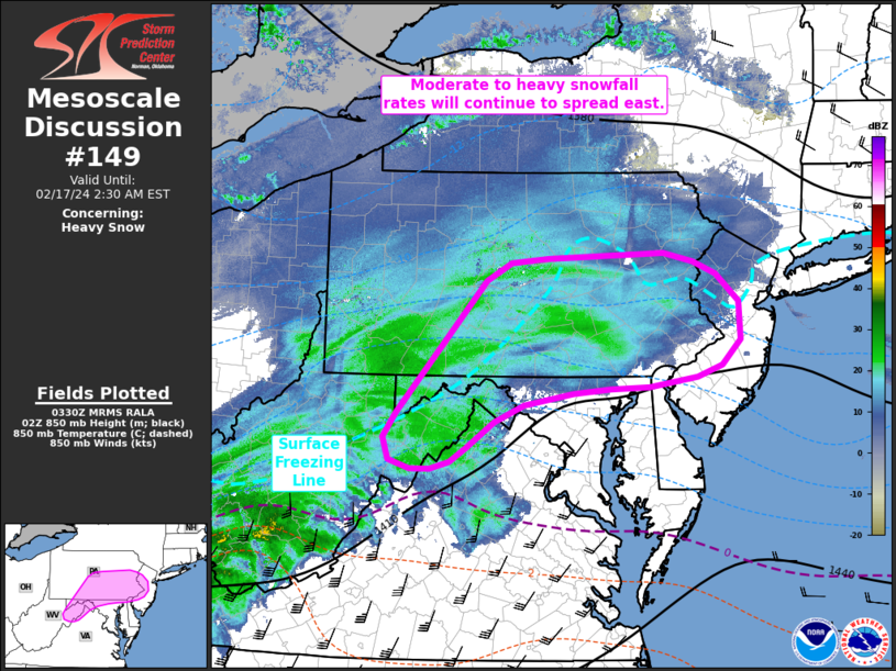
Mesoscale Discussion 0149
   NWS Storm Prediction Center Norman OK
   0933 PM CST Fri Feb 16 2024

   Areas affected...Northeast West Virginia to western New Jersey

   Concerning...Heavy snow

   Valid 170333Z - 170730Z

   SUMMARY...A swath of moderate to heavy snowfall will continue to
   spread east across parts of the Mid-Atlantic over the next several
   hours.

   DISCUSSION...A swath of moderate snowfall continues to spread east
   from the upper OH River Valley region into the Mid-Atlantic based on
   recent regional reflectivity composites. Transient organized snow
   bands continue to be observed within this broader zone, resulting in
   visibility reductions from 1/2 to 1/4 mile and steady snowfall
   accumulations based on recent snow reports from the region.
   Favorable phasing of synoptic ascent ahead of the approaching
   shortwave trough and strong isentropic and frontogenetic lift within
   the 925-700 mb layer, which has been driving this activity so far,
   is expected to persist as the system pushes towards the East Coast
   over the next several hours. Latest forecast guidance depicts
   reasonably high probability in snowfall rates between 1-2 inch/hour
   across portions of the Mid-Atlantic region (and possibly as far east
   as the NJ coast) through 08 UTC. Based on observed trends, this
   depiction seems fairly reasonable. One caveat is a lingering
   warm/dry layer below 850 mb sampled by regional 00 UTC soundings and
   noted in surface observations across northern MD, southeast PA, and
   into western NJ, which may limit snowfall rates in the near term.
   However, a combination of evaporative cooling and persistent
   mesoscale ascent along the warm frontal zone should support adequate
   low-level saturation/cooling to allow for moderate to heavy snowfall
   in the coming hours.
-
1
-
-
-
1 minute ago, JenkinsJinkies said:
I mean it’s not panic if it’s rooted in science. The cards are stacked against us in Ninas and Ninas more often than not double dip.
Go sell miserable somewhere else. We're all stocked up here.
-
4
-
-
LWX pretty much holds with the previous forecast
-
7
-
-
LWX holds serve
Winter Storm Warning
URGENT - WINTER WEATHER MESSAGE
National Weather Service Baltimore MD/Washington DC
911 PM EST Fri Feb 16 2024

MDZ004>006-008-011-503>508-VAZ040-501-505>507-526-171000-
/O.CON.KLWX.WS.W.0007.240217T0400Z-240217T1000Z/
Frederick MD-Carroll-Northern Baltimore-Cecil-Southern Baltimore-
Northwest Montgomery-Central and Southeast Montgomery-
Northwest Howard-Central and Southeast Howard-Northwest Harford-
Southeast Harford-Rappahannock-Northern Fauquier-Western Loudoun-
Eastern Loudoun-Northern Virginia Blue Ridge-
Northwest Prince William-
911 PM EST Fri Feb 16 2024

...WINTER STORM WARNING REMAINS IN EFFECT UNTIL 5 AM EST
SATURDAY...

* WHAT...Heavy snow, with total accumulations of 4 to 6 inches.

* WHERE...In Maryland, Frederick MD County. In Virginia, Western
  Loudoun County, and Northern Virginia Blue Ridge.

* WHEN...From 11 PM this evening to 5 AM EST Saturday.

* IMPACTS...Travel could be very difficult.

* ADDITIONAL DETAILS...Snowfall rates of 1 to 2 inches per hour
  are possible for a few hours under the heaviest snow bands.
  Visibility may be reduced to less than one half mile at times.

PRECAUTIONARY/PREPAREDNESS ACTIONS...

If you must travel, keep an extra flashlight, food, and water in
your vehicle in case of an emergency.

When venturing outside, watch your first few steps taken on
steps, sidewalks, and driveways, which could be icy and slippery,
increasing your risk of a fall and injury.

&&

$$
-
4
-
-
Just now, JenkinsJinkies said:
This busting will hurt because
a) This is probably it for the metros
b) The metros will fail to go above climo
and
c) Next year being a Nina will probably make it a wall to wall torch for the eastern US and very well a repeat of last year.
You need to take a break.
-
5
-
 4
4
-
-
-
Trends ... can't ignore them.
-
1
-
-
Just now, MD Snow said:
HRRR has areas east of 95 raining for 1-2 hrs before the change over. It really only actually snows for 2 hrs east of 95 between dc/Balt. Will be interesting to see if this verifies.
.
-
Play the latest trends ... last minute bumps and then underperformance during the events. Still a good total regardless
-
Totals are gonna be decent but man, those rates - that's the real jewel of this event.
-
Just now, WinterWxLuvr said:
They are all coming in drier

-
1
-
 2
2
-
-
5 minutes ago, psuhoffman said:
You would know

-
3
-
-
9 minutes ago, TSSN+ said:
Not sure that makes sense. Issue watches then lower totals lol
Someone will correct me, but the rates can be watch criteria but the duration shorter, holding down totals. Total accumulation is one criteria.
-
21 minutes ago, Terpeast said:
Not 100% sure for DC south, even mby. If the 18z euro jumps north from 12z, I’m pulling the fire alarm on this
aka "commence the unpinning!"
-
1
-
-
1 minute ago, snowfan said:
So we’re having a board meet up on the mall in dc at 2am? Randy is bringing the drinks.
Live radio show from the Mall.
-
3 minutes ago, jayyy said:
36 hours dude. Not 36 degrees.Shhhh - never waste an opportunity for Ji to complain.
-
1
-
-
-
What's the thought in terms of start time - 3z/4z-ish?
-
6 minutes ago, Maestrobjwa said:
But how can this one trend better, though? It seems like more of a quick hitter...and it's not like we need it to trend souther...so where would the extra juice come from?
It will come from unpinning this thread and then re-pinning it. Pay attention, please.
-
10
-
-
Stick a fork in this one - sun has done it's job and crushed accumulation here. Winds have also dried the roads so no refreeze.


Late Feb/March Medium/Long Range Discussion
in Mid Atlantic
Posted
I see we're moving slowly from the Bargaining stage to the Depression stage ... final one is Acceptance