

PGAWx
-
Posts
82 -
Joined
-
Last visited
Content Type
Profiles
Blogs
Forums
American Weather
Media Demo
Store
Gallery
Posts posted by PGAWx
-
-
37.6 / 22.3. WB 32.5
-
38.3 / 20.5
-
Light snow and sleet on Glenwood Avenue close to Crabtree in Raleigh.
-
34.0 / 19.8
-
Snowing now in 5 points Raleigh area. 32.2
-
Just now, DopplerWx said:
Hrrr still looking like a shot at some snow tonight Into tomorrow
Amounts?
-
Dumping around 5 points Raleigh. 31.0. 3+“
-
41.7 / 28.2 in central Ral. Great timing here. Headed out for a Christmas party before it rolls in early am.
-
1 minute ago, packfan98 said:
Matches pretty well with the Kuchera map from Pivotal:
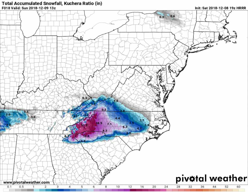
I don’t see the Sandhills (6.3) getting more snow than rdu or gso.
-
Dewpoint dropping like a rock. 44.2 / 29.1
-
5 minutes ago, burgertime said:
RDU per the Hi-Res NAM would get around a foot of snow before changing over to sleep just based on QPF and p-type maps.
Could you please post a map Burger?
-
44.8 / 32.2 in Central RAL.
-
2 minutes ago, Brick Tamland said:
Looks like he increased totals a bit.
It's actually down in Wake at least from 5-9" to 3-7" and he split the county in half (which makes more sense).
-
Just now, Poimen said:
No---sorry if I worded that incorrectly. It's the oppsite. It was going bonkers with precip (1.5" qpf)/snow 24 hours ago and some areas are going to end up with zilch.
Ahh, gotcha. Misconstrued "brutal".
-
1 minute ago, Poimen said:
FWIW, and it may be totally unrelated, but it's interesting that it appears as if the NAM totally busted on the high side out in Oklahoma. Just brutal for some of those areas. Maybe it will bust here equally bad on the low side.
")
To clarify - you mean there was more accumulation than the NAM modeled?
-
Seems easier to drive from ATL to AVL than fly through CLT?
-
Seriously RAH? I get you want to be conservative but 1 inch for the triad looks absurd right now.
-
 2
2
-
-
8 minutes ago, wncsnow said:
on the FV3 at least the heaviest snow amounts are trending north
.thumb.png.9b896684e009942936937c6077092d07.png)
I may be misreading but this conflicts with the FV3 maps that others recently posted?
-
 1
1
-
 1
1
-
-
Already a quick dusting in RTP. Moderate to heavy at times.
-
-
I saw that too and was thinking the same thing. Everyone checked out 3 weeks ago.
-
And DT chimes in 40 min ago:
** ALERT** Massive changes in overnight models now FAVOR late season SIGNIFICANT winter storm Midwest & East coast in the MARCH 5-7 time frame. And NO these changes in the models were NOT there Yesterday..over the past weekend ..or last week.
-
JB not giving in
shades of 1962? Outlined yesterday on weatherbell.com late Feb record eastern warmth and strong positive NAO tanked, and March 1962 turned stormy and cold. Same kind of thing on table this year
-
(Waiting for someone to post about the every Wednesday in March 1960 - http://wxbrad.com/the-year-it-snowed-3-wednesdays-in-a-row-in-march/ ).
It can happen... :/

.png.7268774b13a481efc80b70fc313b5c78.png)
Mid to Long Term Discussion 2019
in Southeastern States
Posted
Incredible amount of excitement/ buzz on the other board about this.