

SteveVa
-
Posts
355 -
Joined
-
Last visited
Content Type
Profiles
Blogs
Forums
American Weather
Media Demo
Store
Gallery
Posts posted by SteveVa
-
-
1 minute ago, Waiting on snow said:
I had high hopes this year because it appears to be solar driven somewhat. 09-10 solar minimum and extreme blocking. The Maunder Minimum and little ice age where the extreme cold over England and the eastern US lasted for decades had to be NAO driven. And that can't be a coincidence that it occurred during the sunspot minimum. I'm sure there are other drivers but that appears to be one.
Published today: https://www.nature.com/articles/s41561-018-0293-3
The North Atlantic Oscillation is the dominant mode of variability of atmospheric circulation outside of the tropics in the Northern Hemisphere in winter. To understand and attribute this mode of variability is of great societal relevance for populated regions in Eurasia. It has been widely claimed that there is a robust signal of the nearly periodic 11-year solar cycle in the North Atlantic Oscillation in winter, which thereby raises the possibility of using the solar cycle to predict the circulation years in advance. Here we present evidence that contradicts this claim. First, we show the absence of a solar signal in the North Atlantic Oscillation in the instrumental record prior to the mid-1960s, and a marginally significant signal thereafter. Second, from our analysis of a global chemistry–climate model repeatedly forced with the sequence of solar irradiance since the mid-1960s, we suggest that the solar signal over this period might have been a chance occurrence due to internal variability, and hence does not imply enhanced predictability.
-
 3
3
-
-
Remember Jan 17/18 event this year? I was laughing at NAM and RAP consistently dumping 10" over OBX...and then OBX got crushed. I wouldn't be so quick to disregard the NAM in this instance, although that event had more cold air to work with
-
1
-
-
Here is the excerpt from AKQ FD...very conservative as usual.
Have also kept the RIC metro in the 1-2 inch range for now.
May need to issue advisories to the
north of the warning and also likely just east of the I-95
corridor, but will hold off doing so until this afternoon to
examine the new guidance coming in to determine the areal extent
of the advisory.
As far as ORF goes, it's looking like a lot of cold rain. Low level NE/ENE flow off the 50 degree ocean is certainly not doing us any favors. I'm still open to the possibility of a slushy coating if the precip rolls in early enough in the morning. Good luck to everyone!
-
4 minutes ago, WidreMann said:
I hope so. Can you find it?
Found it. Sampling makes no difference according to this study, looks like another one of those "6z/18z model runs are inferior" myths that might have been true a while ago.
-
1
-
-
Speaking of sampling, didn't @dtk at one point debunk the theory that models are less accurate if the shortwave is over an area with almost no in-situ observations?
-
1 minute ago, tramadoc said:
They’re normally quite conservative, at least if my memory serves me.
Sent from my iPad using TapatalkYup, just like most offices in the SE when it comes to winter weather. I was surprised to see that the NWS GSP map was legit, would never expect AKQ crew to do the same
-
1
-
-
18 minutes ago, tramadoc said:
I think me,@SteveVa and[mention=14849]SENC[/mention] are on the outside looking in on this one
Sent from my iPad using Tapatalk
I could definitely see a front-end slushy inch or so for ORF and ECG. Something like the 18z FV3 depicts. There is also a possibility of frozen precip for our area on the back side, but models are still all over the place after the low pops into the Atlantic. AKQ is, unsurprisingly, fairly conservative and calls for all rain.
-
1
-
-
That's fake news. Map from 6PM today shows barely 1"
-
4
-
-
Looks like it's all done here in Norfolk near ODU campus. We had a moderate burst of snow around 12:30 that lasted for about 15-20 minutes before precip tapered off. We got a slushy coating on grassy surfaces, but it's long gone now as temp never fell below 33.
-
1
-
-
It's been snowing off and on for about an hour in Norfolk with rain occasionally mixing in. Temperature went from 43.0 to 36.9 since 11am. We could have probably scored a coating had the timing been better.
-
1
-
-
4 minutes ago, BIG FROSTY said:
JB tonight's thought!!
Just a note here to say I have not changed from the idea of a track inside Hatteras to the bench mark and if course that would also be a big city snow threat, This is likely to be a shut down storm for a few days in southern Va into western and central NC But when I look at this see this coming, And 24 horus later, I think the feedback fairy, who is well known, is playing with the model
Ahh, JB's kiss of death for NC and VA.
-
 1
1
-
-
Mods, can we curb constant MBY questions? I'm just sifting through them even though the snowfall map has been posted--it's getting slightly annoying
-
7
-
 2
2
-
-
Got down to 38 once more early this morning. I'd assume we're in for a snow storm later today if I couldn't see the temperature (or the calendar lol) Overcast, calm, and chilly.
-
Got down to 38 this morning in Virginia Beach--coldest temperature this season so far.
Sunny days with lows in the 40s are expected through the end of the work week. More please!
-
1
-
-
On 6/23/2018 at 2:38 PM, tramadoc said:
@SteveVa how did you guys fare yesterday evening with the storms that rolled through. I was watching impressive lightning strike rates on the laptop while it was occurring. Looking to the north from Elizabeth City towards Virginia there was a huge and beautifully formed anvil cloud with amazing veins of lighting moving through it around 730 or so. We missed out on that, but we did pick up a quick .25 of an inch around 0330 this morning from a quick mover.
That storm was awesome, probably one of the most intense I ever experienced lightning-wise combined with gusts in the 40s and heavy rain. There was a 20 minute period of constant lightning and thunder--I even lost power for the first time in a while.
-
1
-
-
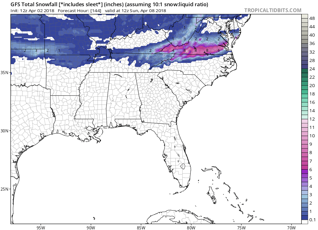
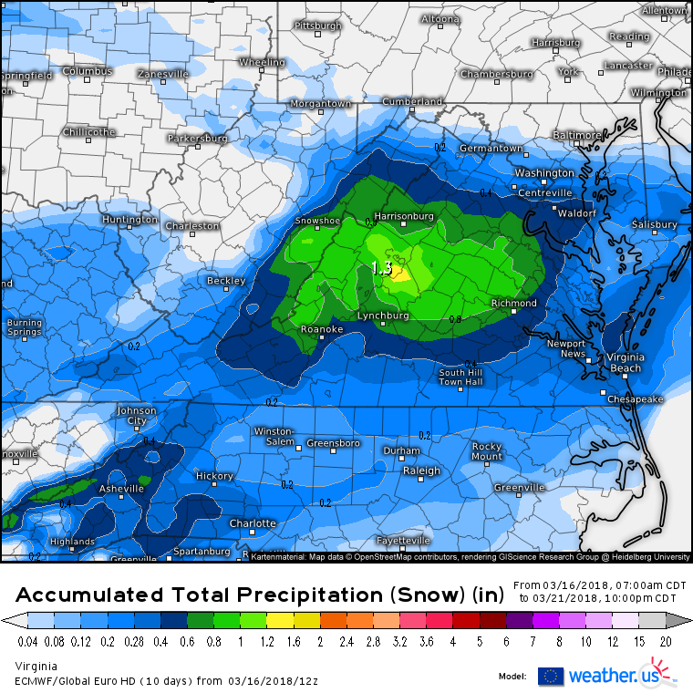
Here are the clown maps from today's 12z GFS and Euro. Amounts likely overdone, but the threat seems legit.

-
If anyone is still here, I think it's worth discussing the 4/7-4/8 time frame as wintry precip is consistently showing up.
Climo says no, Canadian and Euro say hell yes.
-
1
-
-
It just started mixing an hour ago in Virginia Beach. It flips to just snow during heavier rates, but precip is rather weak most of the time. 37 degrees
-
1 hour ago, tramadoc said:
Is that another ULL moving through?
Doesn't look like one on the h5 chart. Looks like a classic shortwave embedded in the trough.
NAM looks pretty damn good for our area at 84. Let's just leave it at that.
-
1
-
-
Drizzle in Norfolk as well. 37 degrees according to the closest PWS, I don't really see any accumulation here unless heavier precip somehow continues after dark. Upper level low doesn't look as consolidated as models depicted..not sure is that just subjective.
Onto Saturday night/Sun night possible event. Timing should be during the night, and I like a 1040+ HP in Quebec. If this stripe shifts 50 mi north, everyone in this thread will cash in.

-
2
-
-
@RIC Airport If I'm reading that correctly, accumulating snow in Norfolk hasn't been recorded past March 20th in the last 44 years? I doubt it snowed much in April.
Edit: Nevermind, just checked the records...0.5" was measured on Apr 11, 1989.
-
1
-
-
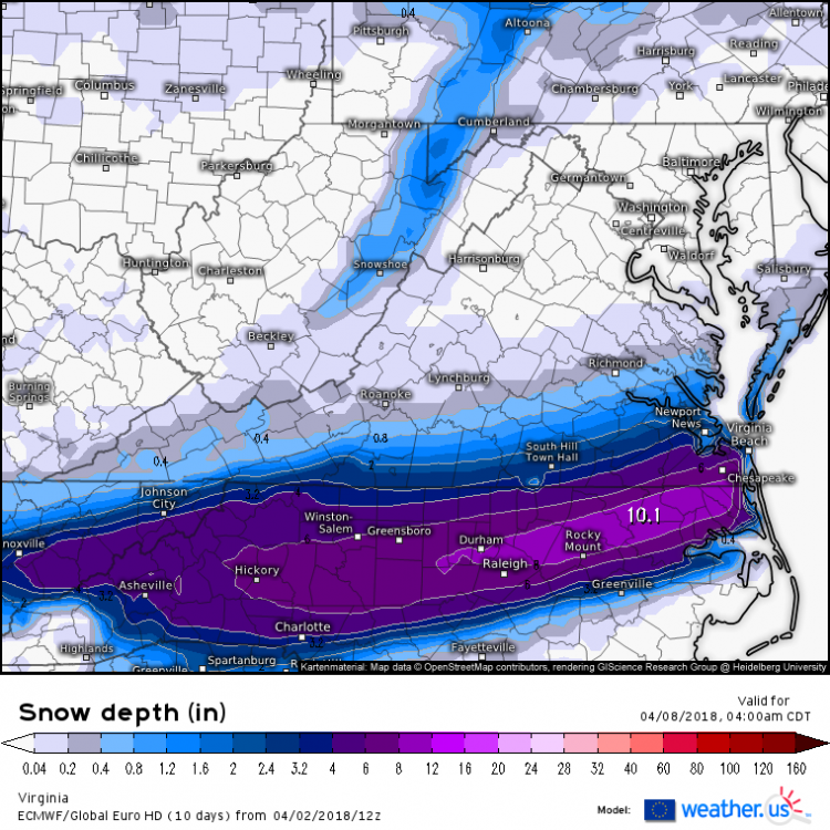
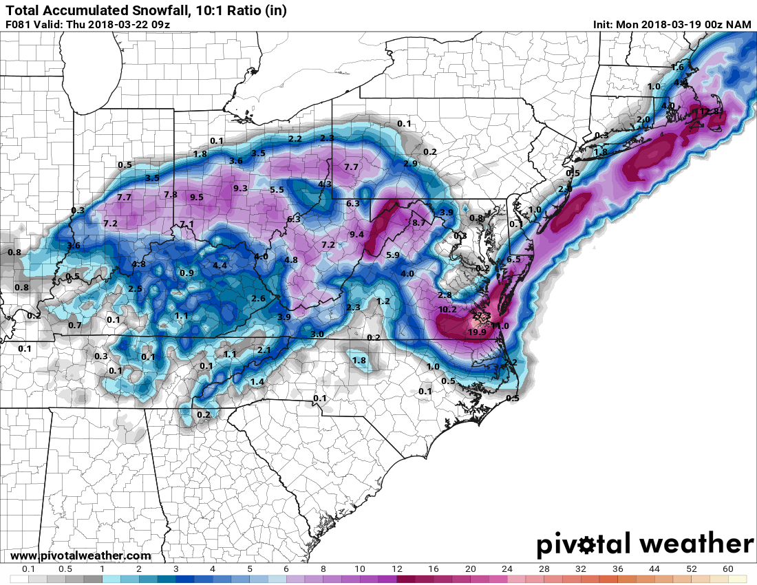
How about that 0z 12k NAM...dumps like 1-2 feet of snow for SE VA. We take? One-tenth of that is my benchmark for this event.
Yes, it's 10:1. Yes, it'll never happen. But holy crap this is crazy.

-
1
-
-
8 minutes ago, DJnVa said:
What's the timing on these events in our area?
It could changeover to snow in ORF early Wednesday AM at best. Potential for frozen precip could extend late into Wed night, keeping in mind that temps will likely be above 32 throughout the event. Still too early for more details.
Rain starts Monday night, changeover to snow probably very late on Tue into early Wed for RIC.
-
Umm...
-
1
-

Mid to Long Term Discussion 2019
in Southeastern States
Posted
I'll always be skeptical about rain to snow scenarios following a cold front. In our neck of the woods we tend to run out of precip before sufficiently cold air arrives. The Arctic front a couple of days ago was supposed to be rain-snow but precip ended before we even got to 40.