

Jonah
-
Posts
29 -
Joined
-
Last visited
Content Type
Profiles
Blogs
Forums
American Weather
Media Demo
Store
Gallery
Posts posted by Jonah
-
-
Breakfast food was pretty big at our house too. We also did frozen pizzas and ice cream. Did that my entire childhood and when I was in college, I always made sure I had those 3 things before a storm.
-
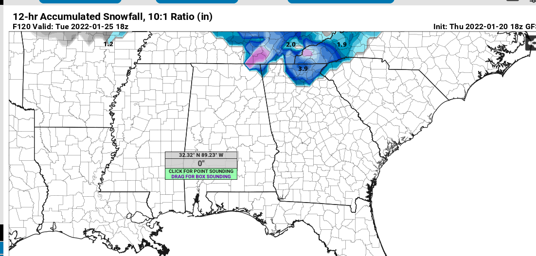
2 minutes ago, burrel2 said:
actually the 18z GFS is already showing some accumulations outside the mountains... good signs. (mountains will almost definitely do really well with this storm if there is some robust precip).
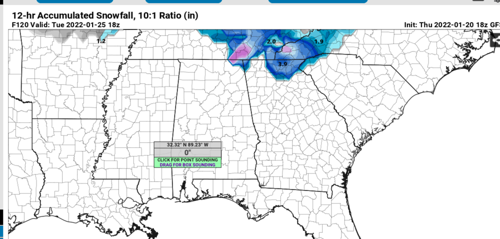
FFC has mentioned the possibility for Tuesday morning for about a day or two now. Here's part of this afternoon's disco:
The next chance for precipitation will return by Tuesday morning as
a southern stream shortwave approaches and its associated surface
low moves along the Gulf Coast. At this point, temperatures appear
marginal for any frozen precipitation in north Georgia. The current
forecast will continue to carry some chance for rain or snow across
far north Georgia in far northeast Georgia Tuesday morning, though
confidence is low
-
Light snow started back again. Very light glaze of ice on some branches. Down to 31.3
-
Snow has stopped for now and the sun's peaking through some. Didn't expect to see any sun today
-
Ha, that was quick. Now moderate snow
-
 1
1
-
-
Sleet started mixing with the rain a few minutes ago now some flaxes getting in too
-
1
-
-
Rain is a little spotty now. Outside looks pretty sloppy but still white.
32.5
-
Heavy coating on the ground and roof now. Sleet starting to mix back in unfortunately but still mostly snow. Down to 33.4 now
-
Coming down pretty good. Back deck has a nice coating on it already. 33.7
-
1
-
-
All snow now. Switch happened about 8 minutes ago. Temps really crashing now, down to 34.7
-
4 minutes ago, SharonA said:
Rain started ~15 minutes ago (south Forsyth County/Cumming), some flakes but mostly rain and here and there some sleet.
Didn't know there were other posters from Forsyth county too! I'm in West Forsyth near the Cherokee line.
36 and mostly rain here
-
Maximum Sustained Wind Overall (mph): 155 mph
Maximum Sustained Wind at Landfall (mph): 150 mph
Pressure at Landfall (mb): 932 mb
Landfall Location: Terreborne Parish -
Mostly ZR with some sleet mixed in. 30.1 currently
-
Just got back to my apartment. Thin clouds filling in. 31.6/18 currently
-
Dewpoint has dropped also. 32.5/18. Forecast low is 27
-
-
12z Euro tries to keep place like Lynchburg, Roanoke, and other areas that were hit hard yesterday below freezing most of the day Thursday

-
1
-
 1
1
-
-
1 minute ago, HoosTC said:
I'm 12 miles NNE of LYH. We had freezing rain, sleet and then snow overnight. About a half inch if snow . Freezing fog now 28.9/26
I'm in the southwest part of the city pretty close to the Bedford and Campbell county line. Went to bed around 2 with heavy sleet and some flakes mixed in. Everything is just a sheet of ice now. 28.6/27
-
1
-
-
update from Blacksburg about 30 minutes ago isn't looking too great
 Quote
QuoteWith regard to tonight, significant icing is expected as the baroclinic zone lifts a bit northwest in response to upper ridging off the southeast/Mid-Atlantic coast. Warm air aloft will support mostly rain across these areas with temperatures below freezing as the wedge holds in tough overnight. Ice accumulations of 1/2 to 1 inch appear likely and possibly more east of the Blue Ridge where current plans are to go with a Winter Storm Warning and a Winter Weather Advisory to the west. More on that later this afternoon, but a serious icing event looks probable for areas like Danville, Lynchburg, South Boston, and other cities in this general area. Stay tuned for updates forthcoming this afternoon.
-
30.2 with heavy sleet. Wish my university would decide what they're gonna do about class tomorrow. Roads are starting to get bad here
-
Temp to 31.3 with moderate zr/sleet. Parking lot getting a little slick
-
10 minutes ago, Ephesians2 said:
"Pingers" in Lynchburg. Seems like a rain/sleet mix, mostly sleet now.
Where are you in Lynchburg? It's about a 50/50 mix of rain/sleet at my apartment. Closest station is reading 32.5
-
Got around 5.5" of snow and sleet. Nice glaze of ice on top. Currently 30.7 and hasn't wavered much today
-
29.7 at the closest station. Parking lot starting to cave but this first band is just about over here. Maybe 0.5-1"
-
1
-
April Observations 2022
in Southeastern States
Posted
Feels more like winter today than all of last December. Light graupel on and off all day. Still only 45 just before 2