-
Posts
358 -
Joined
-
Last visited
Content Type
Profiles
Blogs
Forums
American Weather
Media Demo
Store
Gallery
Posts posted by snowcaine
-
-
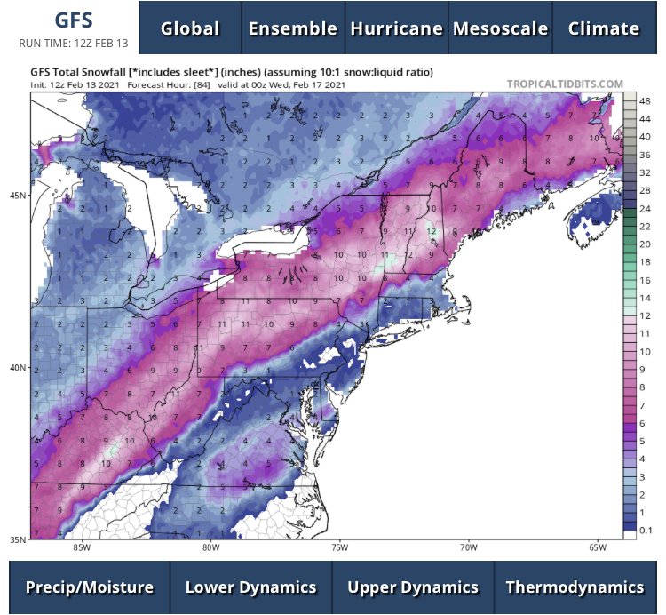
Liking the odds for 8" here in Toronto. Not too concerned with precip type here - FROPA moved in sooner than solutions that had a delayed changeover (eg RGEM)
Wouldn't rule out a run at 10"
-
 2
2
-
-
17 minutes ago, snowstormcanuck said:
Well, I'm going be official stats. Nov 2020 = 19.4cm or 7.7" at YYZ.
Jealous, I got ~5" for that storm
 I recall being surprised at how well YYZ did!
-
 1
1
-
-
41 minutes ago, snowstormcanuck said:
lol, I know right? We grind like champs here.
Except for the big dog on January 28-29, 2019, Toronto has not had an 8"+ snowstorm since the 2014-15 winter. By contrast, we've had 17 snowfalls in the 4-8" range in that same period.
It's funny you say that. I counted this morning out of curiosity and I have had only 6 events above 6" in the last six years, and only one was above 8" (which was the 13" storm in Jan 2019)
Averaging 1 event over 6" per season is kind of depressing when you think about it
-
1 minute ago, Snowstorms said:
Nice paste job this morning. Just over 2" at YYZ. Enough to put us slightly above average for the season. Another 9" more and we'll beat every winter since 2008-09.
It's hard to believe given I have yet to have an event drop more than 5" this season! Lots of little events
-
One of those situations where it could be 0 to 9 inches anywhere along a 60 mile distance.
My forecast would probably be 3" for Toronto, but 0" is entirely possible, as is 7"
-
 2
2
-
-
48 minutes ago, snowstormcanuck said:
Early days but so far flake size is a bit underwhelming. Still time for that to change but given this is a quick hitter going to need things to ramp up in the next 1.5-2 hours.
I usually find that an average between Kuchera and 10:1 works out best. Unless it's lake effect or slop, then Kuchera all the way.
7" seems like a good bet to me at this stage.
-
5 minutes ago, mattb65 said:
Good luck with that, not sure why you want more lockouts with numbers dropping so dramatically.
This is Canada's new obsession: stop the variants!
-
3 hours ago, snowstormcanuck said:
I'll take the under...it'll be close though.
I would think 30 cm is more likely on ground by Friday, especially factoring in sublimation and compaction between events. 60 cm would be heavenly but I would be surprised.
My guess is 20 cm of snow from today's event, 10 cm on Friday. Maybe I'm pessimistic, but we've been screwed by overblown Kuchera rates before (even if we're in prime dendrite growth zone thermally, seen far too many rod events when I was hoping for dendrites). And the Thursday night system looks like a classic coastal capture - we'll see how far west the snow shield penetrates, but again wouldn't be surprised to see less-than-ideal snow ratios, especially with such dry air on the doorstep to eat away at that moisture.
-
-
3.5" here in Toronto overnight. A bit less than I had hoped but I'll take it especially for Christmas!
Merry Christmas everyone
-
 2
2
-
-
16 hours ago, Angrysummons said:
ECMWF has been garbage lately. Generally the GFS has been the worse model this time of year in the past, but not this season.
It's funny you mention model quality lately. I've found the GFS to be abysmal too. Oddly enough, the Canadian has been my go-to the last month. 2013-14 was the last winter that I found the Canadian to do really well, so I wonder if they've made changes to the model recently.
-
9 hours ago, Jackstraw said:
The Buffalo NWS office has said that they like the Canadian model suite best for lake effect snow guidance in general
-
 2
2
-
-
33 minutes ago, michsnowfreak said:
one saving grace is the virus has lost its potency from spring.
We're testing about 4x as much, I am sure actual caseload was much higher in the spring than numbers suggested.
Also, outbreaks in hospitals and care homes burned through our weaker/most vulnerable population early. Kind of like how dry, dying branches are the first to burn in a forest fire, resulting in a forest being less vulnerable/susceptible to future fires (or in this case, virus waves). It's unlikely virus potency is any worse or less than before, especially given that coronaviruses in general are fairly stable (in that they typically don't mutate to become any more or less severe over time).
-
On 3/25/2020 at 6:55 AM, King James said:
Local hospitals started letting staff go they are so quiet
If there is a surge there is plenty or room and staff ready to get back to work as well as millions of others
I know you aren’t a fan of this but people got to get back to work. They dropped the ball on this big timeThey did drop the ball. They didn't act sooner.
We shall see how this post holds up over time. Be part of the solution, not the problem.
-
 1
1
-
-
3 hours ago, Snowstorms said:
58 new cases today. People continue to travel and go outside their homes for non-essential things. Until that stops, this won't stop spreading.
I'm working from home till mid April. I have a feeling that'll likely get extended till May and perhaps even our schools and other businesses. It ceases to amaze me that some people think this is some sort of conspiracy. Nobody is gaining anything from this.
Well you can go outside your home for a walk or something. I'd say that's a low risk activity as long as you're respecting physical distance from others.
-
 1
1
-
-
16 hours ago, snowstormcanuck said:
But the wind component for blizzard criteria was non-existent in that storm.
Sustained at YYZ may seem low but gusts met criteria. Additionally, YTZ was 30-40 G 50-60 most of the event. Just need sustained or gusts over 40
Jan 2019 beats Feb 2013 for me because it happened during the day. Amounts were similar. But definitely the Dec 2013 ice storms wins this competition, with July 2013 floods a close second. 2013 was a busy year for Toronto.
-
6 hours ago, snowstormcanuck said:
I checked...it doesn't look like it. Unless I'm looking at the wrong storm.
Jan 28, I have it recorded that visibility was 400 m or less from 1:15 pm to 3:45 pm, so about an hour and a half short I guess. Criteria is 4 or more consecutive hours of 400 m or less. Toronto island was under 600 m for nearly 6 hours which is pretty impressive. I believe downtown and midtown were hit hardest compared to YYZ and YTZ but we don't have visibility observations for the city centre itself. I got 35 cm at my place and I could barely see the house across the street for hours. Definitely my favourite storm I've ever experienced.
-
12 hours ago, snowstormcanuck said:
Lived almost my entire life in Toronto and we've never been under a blizzard warning
 .
.
So, you're looking at 2.5-3 feet of snow basically. Photos would be swell!
We were one hour short of Blizzard conditions for the late Jan 2019 storm.
-
I ended up with 6" on the nose here in midtown Toronto on my snowboard, seems to line up nicely with other reports in the area.
Chance for a glancing snow squall sideswiping us tomorrow, but I am not expecting anything too exciting. The gusts this morning have been impressive though, some snow blowing around off buildings.
-
 1
1
-
-
12 minutes ago, snowstormcanuck said:
It's been tough to get visibilities below 1SM. Was hoping for a little rippage.
Yeah it's been a bit disappointing. 6" over a 24 hour period is way less exciting than over a 6-12 hour period.
-
 2
2
-
-
Big returns pushing in from the south. Will be a nail biter.
-
1 hour ago, snowstormcanuck said:
12z 3km NAM has a foot at YYZ, 8 or 9 inches from the synoptic and then the rest from a gnarly lk huron band afterwards with impressive inland penetration.
Sounds like fun.
The 3km NAM is a dream.
I think 6-8" seems like a reasonable call but my cautious side thinks 6" seems feasible. I would love some bonus lake effect though.
-
1 hour ago, roardog said:
Are the residents of Winnipeg jealous of you Toronto folks in the Spring with your "warm" weather? lol
Whenever people from Ottawa visit me in Toronto during the winter or spring they always talk about how "tropical" our weather feels in comparison haha
-
6" seems like a reasonable call for Toronto at this point, I'll take it.


Winter 2021-22 Complaint/Banter Thread
in Lakes/Ohio Valley
Posted
I'm probably late to the party here, I haven't been very active on here the last few years, but has anyone else noticed that the GFS has been particularly bad this winter?