

metallica470
-
Posts
30 -
Joined
-
Last visited
Content Type
Profiles
Blogs
Forums
American Weather
Media Demo
Store
Gallery
Posts posted by metallica470
-
-
1 minute ago, SchaumburgStormer said:
Beautiful hook echo on that geneseo cell
Just saw that. Looking really interesting now
-
34 minutes ago, Chicago Storm said:
Some sort of gravity wave type of feature has moved across the metro/NE Illinois, with a brief, but sharp increase in winds.
ORD gusted to 55MPH.
.That was wild! I was out with the dogs when that came through. I was wondering what just happened as it seemingly came out of nowhere and caught me and my dogs by surprise!
-
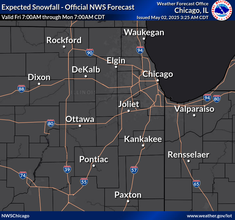
Latest LOT snowfall map:
-
 1
1
-
-
2 minutes ago, Chicago916 said:
Ukie said hold my beer
Looks like it's picking up the lake enhancement?
-
3 minutes ago, nwohweather said:
That’s shocking. Not much rotation on radar
Yea, must have been very brief if anything.
-
Or maybe not? Verbage was in the warning, but not any longer.
-
Confirmed tornado in Glen Ellyn
-
 1
1
-
-
looks like maybe some rotation on the storm north of Pontiac?
-
On 2/27/2023 at 4:53 PM, Frog Town said:
It'll be back to it's Sunday solutions by 12Z Wednesday.

-
3 minutes ago, sbnwx85 said:
Cheyenne just dropped 40 degrees in one hour.
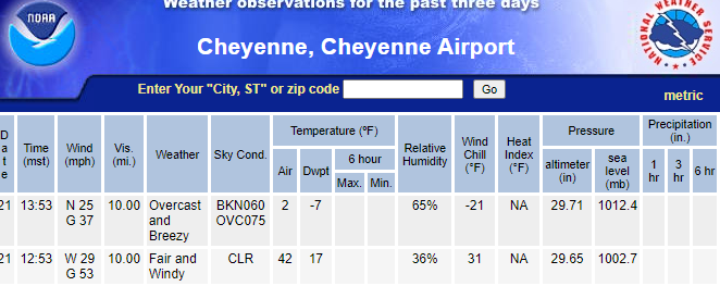
According to the NWS twitter page it was 40 degrees in 30 minutes!

-
5
-
-
Looks like rotation picking up just northeast now of Chenoa
-
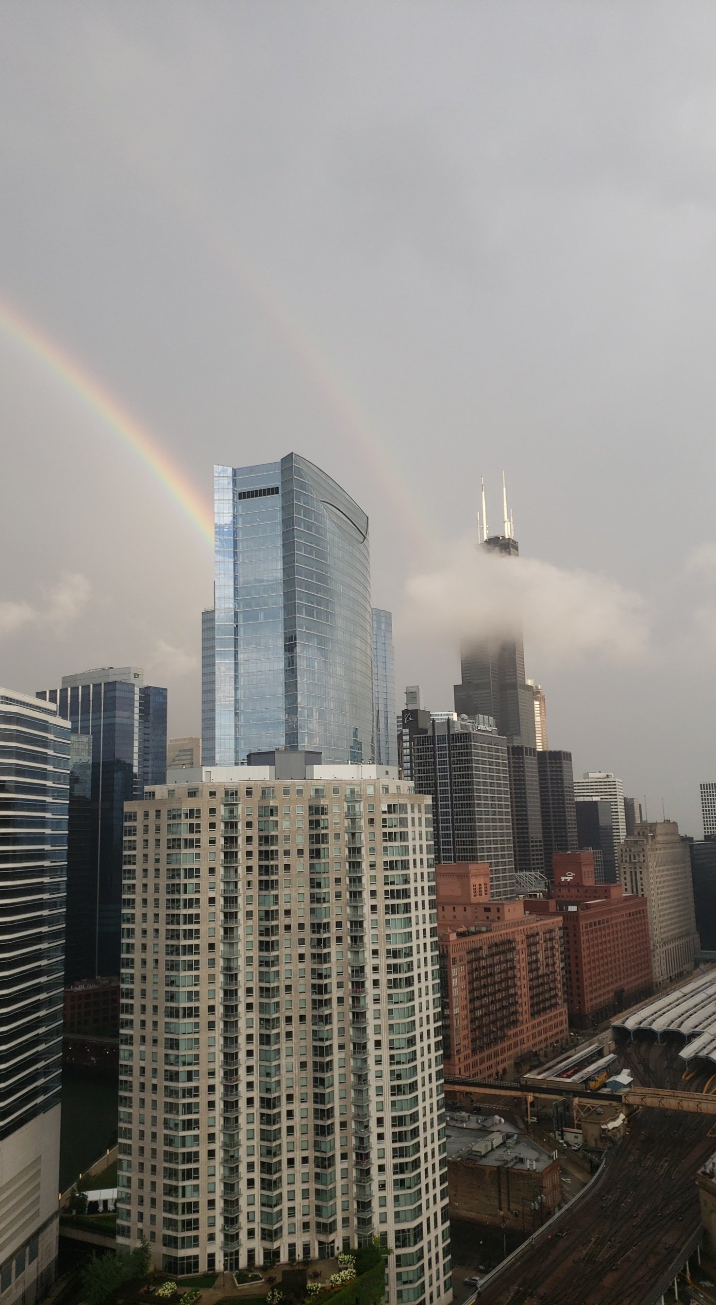
Just made the journey from the south suburbs to the loop. Started mostly as rain then on i94 it was coming down pretty good for a few mins. Not much accumulated, but definitely had flashbacks to driving in the GHD storms. Not so much going on here now.
-
32 minutes ago, McHenrySnow said:
Those counties aren't going to get lake enhancement.
Oops my bad. Meant to quote the wsw a couple posts before lol
-
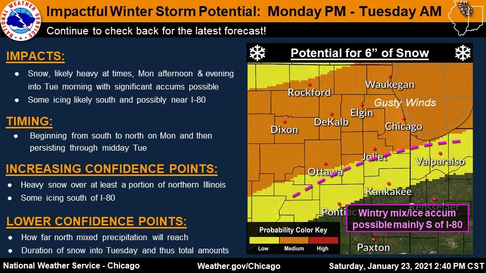
8 minutes ago, McHenrySnow said:
Winter Storm Warning
URGENT - WINTER WEATHER MESSAGE
National Weather Service Chicago IL
255 PM CST Sun Jan 24 2021

...Winter Storm to Impact the Region Beginning Monday
Afternoon...

ILZ003>005-250500-
/O.UPG.KLOT.WS.A.0001.210125T2200Z-210126T1800Z/
/O.NEW.KLOT.WS.W.0001.210125T2200Z-210126T1800Z/
Winnebago-Boone-McHenry-
Including the cities of Rockford, Belvidere, Crystal Lake,
Algonquin, McHenry, and Woodstock
255 PM CST Sun Jan 24 2021

...WINTER STORM WARNING IN EFFECT FROM 4 PM MONDAY TO NOON CST
TUESDAY...

* WHAT...Snow, heavy at times, especially Monday evening and
  overnight. Total snow accumulations of 5 to 7 inches. Northeast
  winds gusting as high as 35 mph resulting in periods of very
  low visibility.

* WHERE...Winnebago, Boone and McHenry Counties.

* WHEN...From late Monday afternoon through Tuesday morning.

* IMPACTS...Travel could be very difficult. Hazardous conditions
  are likely to impact the Monday evening and Tuesday morning
  commutes.

* ADDITIONAL DETAILS...Some power outages are possible due to
  the combined effects of the expected wetter nature of the snow
  and strong and gusty winds.

PRECAUTIONARY/PREPAREDNESS ACTIONS...

If you must travel, keep an extra flashlight, food, and water in
your vehicle in case of an emergency.

The latest road conditions for Illinois can be obtained on the
internet at www.gettingaroundillinois.com
LOT better be praying for some nice lake enhancement to reach those totals lol
-
1
-
 1
1
-
-
LOT Latest thinking
-
11 hours ago, BuffaloWeather said:
I think we see a dramatic rise in cases for several months but deaths won't likely keep up with the trends of previous months due to better treatment. Vaccines likely start early next year. Going to be a rough couple months though.
Just curious, what is the better treatment being done now that wasn't being used in the first few months?
-
1
-
-
7 hours ago, Malacka11 said:
Just gonna leave this here.
Those of you who believe Trump's actions do not directly impede efforts to curb Covid are a bunch of colossally ignorant morons.
What else would you really do though besides going into a complete lockdown? Here in Chicago you can't go anywhere without a mask on and restrictions have been in place since nearly the beginning of all of this and the numbers still continue to shoot up.
-
-
3 minutes ago, Hoosier said:
Looks like ORD will top out at 89 or 90.
Definitely feel that. With the humidity feeling like low 90s today! Definitely a shock after being pretty cold until just recently.
-
1
-
-
56 minutes ago, King James said:
Went to HS in OF, go Bengals, drive safe
Small world! I actually have to update my profile as I live in Chicago now, but grew up in OF! You drive safe as well!
-
2 minutes ago, King James said:
Not the main event but a co-worker just called me in the Cal City/Lansing/South burbs of Chicago and said there are many many spinouts and accidents right now and the roads are about as bad as he's ever seen them. Not sure what's causing this but I figure this is a good place to let someone know.
Same here as well. Lot of coworkers said they have been spinning out with black ice everywhere.
-
Extensive tree damage and flooding throughout Chicago Ridge and the Oak Lawn
-
3 minutes ago, SchaumburgStormer said:
Velocity doesn’t look great at the moment. May be cycling
Yea, looks like it let up right around Lewistown which would be good news
-
New warning says confirmed tornado over Lewistown

February 27-28 Severe Threat
in Lakes/Ohio Valley
Posted
The other north of Alpha looking interesting too. Both happened nearly at the same time.