

Stormsfury
-
Posts
659 -
Joined
-
Last visited
Content Type
Profiles
Blogs
Forums
American Weather
Media Demo
Store
Gallery
Posts posted by Stormsfury
-
-
28 minutes ago, nwohweather said:
Looks like it’s been a rough day for my old stomping groundsBeen off and on rapidly moving heavy bands, wasn't aware a spin up occurred just a mile away until it was all over the news. It was tornado warned though.
Quite an interesting day, despite not much wind so far but that'll change within the couple hours or so
-
Tornado in Goose Creek from a band. Happened on St James Ave near US52. This is less than a mile from where I'm at.
https://widgets.burst.com/fd2cb8d6
-
 2
2
-
-
29 minutes ago, accountingdawg2012 said:
Almost 25% of the island appears to be without power. There's about 15K that live there and outages are already over 3200.
That's crazy... 3pm St Simon's GA S 26 gusts to 66!
Regional Weather Roundup
National Weather Service Charleston SC
300 PM EDT WED AUG 30 2023

NOTE: "fair" indicates few or no clouds below 12,000 feet with no
significant weather and/or obstructions to visibility.

Not all stations are quality controlled. Use data with caution,
especially dewpoint observations.

SCZ027-030-031-034>040-042>050-302000-
...Southeast South Carolina...

CITY           SKY/WX    TMP DP  RH WIND       PRES   REMARKS
N Charleston   LGT RAIN  78  76  93 E23G29    29.58F FOG
Waterfront Prk   N/A     79  77  94 E17       29.46F
Mount Pleasant HVY RAIN  79  79 100 E10G21    29.61F VSB<1/4
Johns Island   CLOUDY    81  81 100 SE17G25   29.58F FOG     HX  91
Pinopolis        N/A     77  75  94 E8G15       N/A
Moncks Corner  HVY RAIN  75  73  94 E8        29.64F
Summerville    HVY RAIN  77  75  94 NE9       29.59F FOG
Beaufort MCAS  CLOUDY    82  80  94 SE13G25   29.48F HX  94
Beaufort Arpt    N/A     81  77  89 SE14G26   29.49F
Hilton Head Is NOT AVBL
Walterboro     RAIN      75  75 100 E16G31    29.56F
Allendale      LGT RAIN  75  75 100 E8G18     29.53F FOG

...Southern Midlands and Pee Dee...

CITY           SKY/WX    TMP DP  RH WIND       PRES   REMARKS
Georgetown     HVY RAIN  73  73 100 E3        29.68F VSB 1/4
Kingstree      LGT RAIN  77  73  88 E6        29.70F
Orangeburg     RAIN      75  75 100 NE13G22   29.62F FOG
Barnwell       HVY RAIN  75  75 100 NE21G26   29.58F VSB 3/4
Aiken          HVY RAIN  74  72  94 NE21G30   29.66F FOG
Manning        LGT RAIN  73  73 100 MISG      29.68F
Columbia       RAIN      77  76  96 NE12G20   29.68F FOG
Sumter         HVY RAIN  77  76  95 NE12      29.69F VSB 1
Florence       RAIN      81  78  91 NE12      29.72F FOG
Myrtle Beach   LGT RAIN  78  78 100 VRB7      29.72F
N Myrtle Beach LGT RAIN  77  75  93 E6        29.73F

$$

GAZ063-065-086>088-099>101-113>116-118-119-134>141-150-302000-
...Southeast Georgia...

CITY           SKY/WX    TMP DP  RH WIND       PRES   REMARKS
Savannah Arpt  LGT RAIN  81  77  88 SE28G40   29.37F FOG
Hunter AAF     LGT RAIN  81  66  59 SE22G38   29.36F
Fort Stewart   CLOUDY    81  77  89 SE29G36   29.22F
Statesboro     HVY RAIN  76  73  93 NE12G18   29.42F
Sylvania       RAIN      76  76  98 NE9G17    29.47F
Claxton        HVY RAIN  80  78  95 E20G31    29.32F VSB 1/2
Millen         RAIN      74  73  95 N13G22    29.53F FOG
Metter         HVY RAIN N/A N/A N/A NE16G24   29.36F VSB 1
Reidsville     HVY RAIN  77 N/A N/A N15G26    29.27F VSB 3/4

...CSRA, Central and far Southeast Georgia...

CITY           SKY/WX    TMP DP  RH WIND       PRES   REMARKS
Thomson        RAIN      74  72  92 NE17      29.65F FOG
Augusta-Bush   HVY RAIN  73  72  96 NE21G29   29.59F VSB 1
Augusta-Daniel HVY RAIN  74  72  93 NE13G23   29.64F VSB 1
Swainsboro     HVY RAIN N/A N/A N/A N15G29    29.48F
Vidalia        HVY RAIN  73  73 100 N16G30    29.37F
Eastman        RAIN      72  72 100 N17G25    29.49F
Hazlehurst     HVY RAIN  73  72  95 N28G41    29.26F
Alma           LGT RAIN  78  77  96 N15G28    29.11F
Waycross       CLOUDY    79  79 100 W23G33    29.13R
Jesup          NOT AVBL
Baxley         HVY RAIN N/A N/A N/A NE17G25   29.14F
Brunswick      NOT AVBL
Saint Simons   CLOUDY    86  76  71 S26G66    29.32F HX  96
-
 1
1
-
-
47 minutes ago, GaWx said:
Hopefully not. It appears that the center may be tracking inland of Savannah a decent amount, which would keep winds down somewhat vs how high they might have otherwise been. Combined with the quicker weakening vs NHC forecasts that I just posted about, that combination would be good news to keep winds down from how high it earlier appeared winds might get. I earlier thought outages would be widespread along with numerous trees down throughout the area. That may still end up being the case as winds are picking up and will get strong by late afternoon. But perhaps it won't be as bad as earlier feared.
At 2 PM strongest winds I saw came from St Simon's, GA.. S 33 gust to 59!
-
1
-
-
16 minutes ago, GaWx said:
Some good news. Compared to the 5AM NHC forecast, it has weakened quite a bit more quickly than forecasted then. The 5AM had Idalia still with winds of 100 mph as of 2PM. But as of 1PM, winds were already down to 80.
The 11AM had adjusted for this quicker weakening because it was already down to 90 then. This updated forecast had it weakening from 90 at 11AM to 75 at 8PM. But with it already down to 80 at 1PM, it appears that it is weakening even more quickly than the 11AM NHC forecast.
The ERC just before landfall had a hand in a quicker spin down than first anticipated, and not the feared to be rapidly deepening thru landfall scenario.
-
3
-
-
1 hour ago, nwohweather said:
It looked like for 20-30 minutes it had a potential to put down a small tornado. Definitely a lack of wind shear and "storm crowding" affected the inflow once it got past MC
Yeah, once more cells erupted on the sea breeze front to its SW, it choked it off. The seabreeze boundary gave rise to a spike in helicity. I did see another clip posted from WCIV and it appeared there was a brief touchdown.
No question, the rounds and rounds of strong to severe thunderstorms, particularly in Berkeley County served to dump anywhere from 3"-6" of rain on Doppler radar estimates. The lightning yesterday was prolific..
-
Absolutely insane day in Goose Creek today. No less than 8 cells blasting thru... One hailer, non stop lightning basically since 6pm...
My friend caught the Moncks Corner large wall cloud/possible tornado on video today and yesterday, the Summerton, SC tornado...
https://www.youtube.com/watch?v=JBVrEJTjupM
The guy caught outside was actually trapped. It was at Black Creek Golf Course and the clubhouse was locked so he was forced to ride it out for dear life...
-
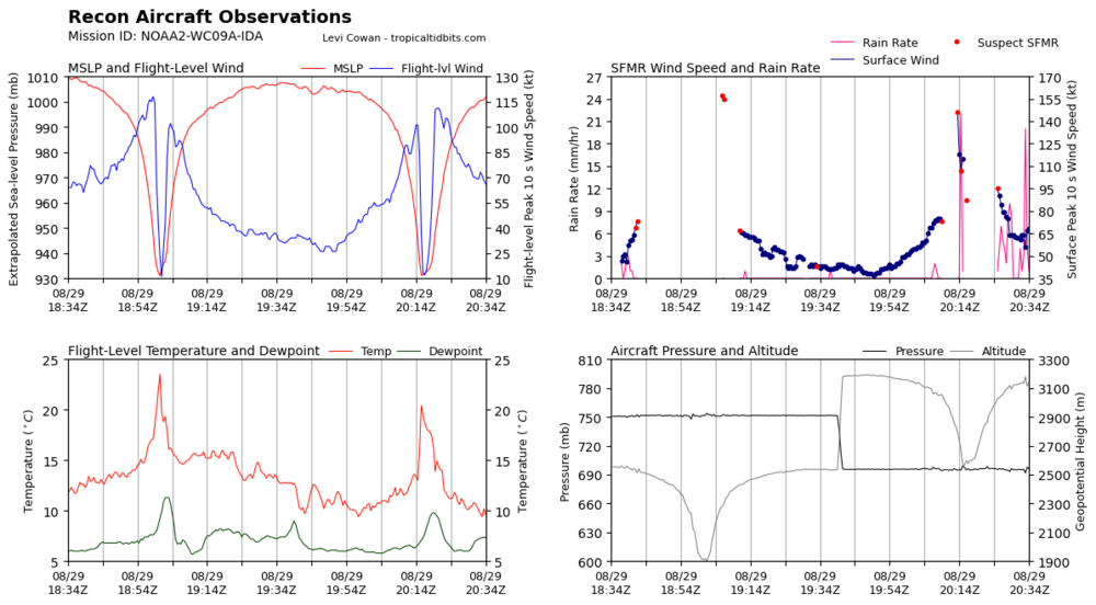
Flight level winds and winds down but appears recon still finding pressures in the 930mb range... Insane..
-
3
-
-
galliano, LA is in the moat right now. jokko is obviously reporting in kilometers.. the conversion makes sense to miles from his numbers.
Galliano, LA had an 11mb pressure fall in 1 hour. 29.00" (982mb) at noon CDT to 28.67" (971mb) at 1pm CDT
-
1
-
-
1 minute ago, wxeyeNH said:
I don't know who he is but certainly no Met. Just said 177mph gusts. I'm turning the volume off but he is in the best position if you want to experience Cat 2 or Cat 3 winds which I assume are coming to his location
Coming soon . He's in the moat right now in between the 2 eyewalls.
-
4 hours ago, NTriadwx said:
 What’s the deal with this? Anyone seeing lightning or hearing thunder?
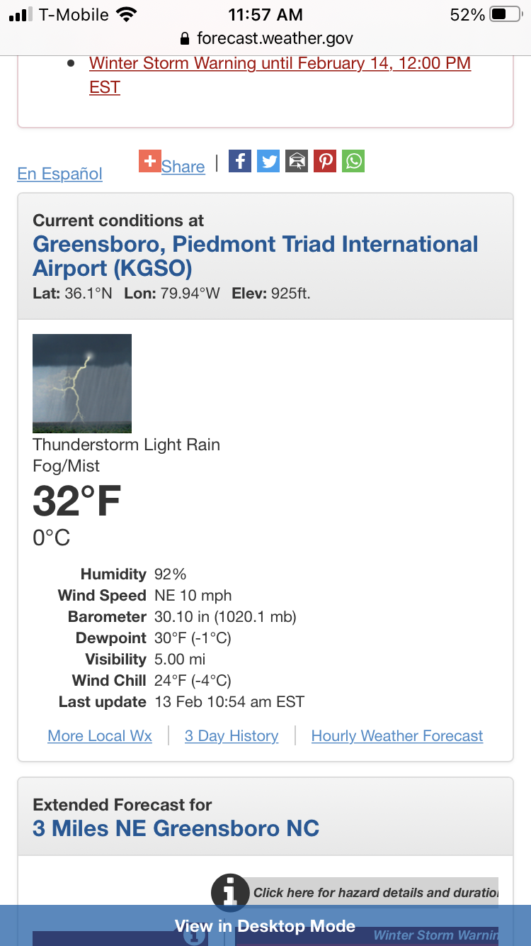
I don't doubt it... Charleston SC had a thunderstorm with heavy rain at 41... Back here in Goose Creek at work, 39° with same heavy rain/thunderstorm..
-
47 minutes ago, Ser Pounce said:
And this is the kind of thing that I'm definitely watching out for. Don't have an models or the NHC in front of me at the moment, but wasn't that turn supposed to happen later tonight?
Yes. The bend back supposed to start later. Magic number is 34.0°N now...also could be everything determining an actual landfall versus a skirt on SE NC
-
1
-
-
From 11am to 2pm.
Florence moved .2°N to .5°W and looks like she continues to slow down and bend left. NHC official plot line is 34°N INLAND... Florence may not even make it to 34°N now... all the guidance to some degree show a WSW component. Very critical downstream on effects in SC.
-
46 minutes ago, wncsnow said:
GFS scenario is actually the best I have seen. It stalls the storm just far enough offshore to miss the worst effects of the eyewall and torrential rain. Still offshore by 120 but bearing down on Charleston as what would be a much weakened system.
Yes, the simulated IR Satellite has a large cluster/blob of rather disorganized convection due to shear
-
1
-
-
9 minutes ago, Jet Stream Rider said:
This has to be a surprising look for folks along the coast south of Charleston that may have considered themselves out of the woods.
Yes that would an understatement. This was unfortunately the exact solution I was worried about early this morning considering the disturbing trends that have developed since last night's 00z run whichI assume had more upper air soundings and data.
-
3
-
-
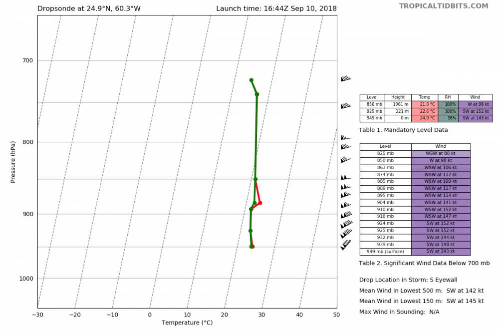
Last pass of RECON found 143kt winds on the S Eyewall per dropsonde.
-
1
-
-
2 minutes ago, Blue_Ridge_Escarpment said:
So we went from WNW to due west movement in he latest advisory. Interesting.
Yes. Latest WV to my eyes seems to have ridging trying to build NW of Bermuda as opposed to N
-
1
-
-
14 minutes ago, Solak said:
11:00 AM AST Mon Sep 10
Location: 25.0°N 60.0°W
Moving: W at 13 mph
Min pressure: 962 mb
Max sustained: 115 mphFlorence has been moving practically due west the last 6 hours...straddling 25.0°N.
For those wondering about how unusual this scenario is with Florence, interesting graphics were produced several days ago...
On Sept 5...only a few impacted the US where Florence was on this date. A few days later, a new graphic from I believe Weather Underground showed since 1851, 67 storms passing within 200 miles of Florence... ZERO made a US impact...
Florence likely will be rewriting the rulebook.
-
2
-
-
2 minutes ago, isohume said:
I noticed that too. Upper level div is strong, but cross sections show no deep omega coupling with meager llvl forcing.
That explains it a bit...Always missing one or more ingredients to bake a masterpiece .
-
1 minute ago, NCSNOW said:
Webber has been preaching the same thing on other board. Says its very rare almost unheard of to get a jetstreak like GFS is depicting in our neck of the woods like 140-160. Thinks this favors an overperformer potential to the NW(should get way more precip) as oppossed to the latter.
Saw that and I think that is pretty spot on. Also just saw WPC experimental day 4 outlining 10% chances with greater than .25" liquid equivalent frozen/snow highlighted from northern SC thru Central/Eastern NC on their Winter Weather graphics.
The CMC/GFS differences at 250mb are very subtle with the jet streak...
-
The 12z GFS has an intensifying screaming jet at 66 thru 84 at 250mb. Precip seems rather meager with such a jet enhancement...
-
4
-


Idalia to heavily affect large portion of SE
in Southeastern States
Posted
That spin up hit a mile away from where I live.