

HWY316wx
-
Posts
767 -
Joined
-
Last visited
Content Type
Profiles
Blogs
Forums
American Weather
Media Demo
Store
Gallery
Posts posted by HWY316wx
-
-
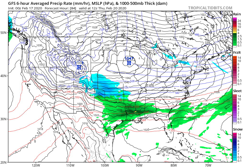
Fair warning, I am flying into NJ and staying in Northern NJ tomorrow. I am sure to make the snow not show up, so when it doesn't, it's my fault. I will take the blame for this one. That said, comparing the GFS to the EURO (just ignoring the NAM) I think a 50/50 blend of the GFS and EURO is probably safe and that essentially ends up being the EPS. Honestly I am pulling for the NAM but it's like the drunk Uncle at Thanksgiving. Fun to listen to but what he's saying is complete garbage.

-
 1
1
-
-
Everyone from GA to NC will have to look at snow totals fast as temps climb quick as it exits stage right.

-
 1
1
-
-
29 minutes ago, Cheeznado said:
I was getting a bit discouraged with the GFS refusing to budge and the 00Z Euro not that great either for Atlanta but the 06Z Euro and the new NAM has made me feel better for now. Now we'll see if the GFS comes around or at least trends in this direction.
Glad to see you Cheeze. Always enjoy your input.
-
1
-
-
WEENIE RUN ON THE NAM. WOW
-
3
-
-
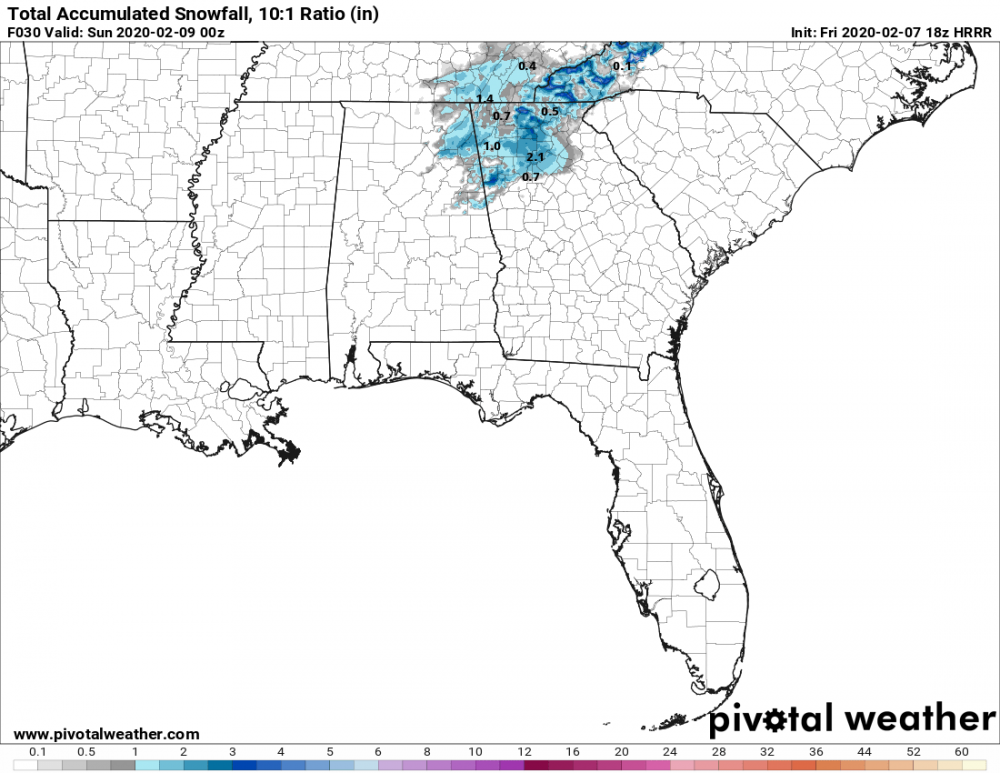
6z EURO… LPS is on the panhandle of FL. Oh boy.
-
5
-
 1
1
-
-
Saw this on Twitter. It depicts everyone watching the GFS, EURO, UKMET and now the NAM…

-
7
-
-
Some maps show 60 MPH over my head. A little scary as I have a bunch of large trees on the south side of my house.
This thing is hauling butt. -
6 minutes ago, SnowDawg said:
It would appear so but no surface temps were not an issue on the UKMET. It's the same issue it has had since the beginning and that's extremely suppressed moisture. Again, this is what the surface temps over NC are going to look like if there is no sufficient precip to drive down the temp.
It's exactly what we had last weekend in regards to temps. Had the moisture not gotten heavy and held the temps down it would have never have happened. I think I am probably out of the game on this one, but I haven't thrown in the towel yet. The NAM really didn't start nailing the system down from last weekend until 48 hours out and even then the actual totals ended up being better than advertised in many places.
If I was in NC having seen the setup that we did here in GA last weekend, I would be very optimistic about Thursday / Friday. -
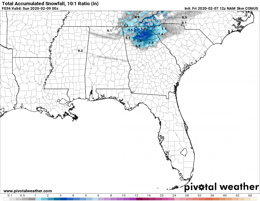
00z NAM 32k vs. the 00Z GFS
If these were babies, they would be twins.


-
Just saw this in the NWS disco out of Peachtree City.
"...
and possible areas of
freezing fog in and along the I-20 and I-85 corridors. For now,
these threats will be discussed further in a Special Weather
Statement."
-
11 minutes ago, mackerel_sky said:
Freezing fog won’t be an issue here tonight, stratus deck and 36 degrees here, seen this show, temps won’t go any lower than 34, IMO
It's 32.4 here and dropping and progged to go to 30.
-
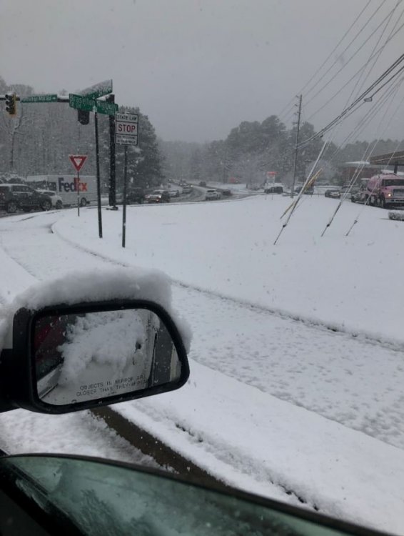
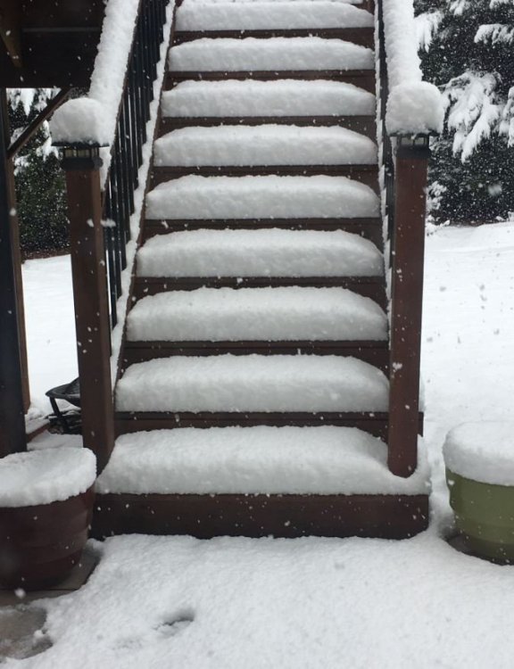
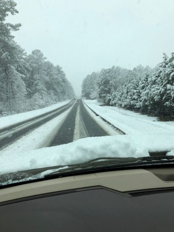
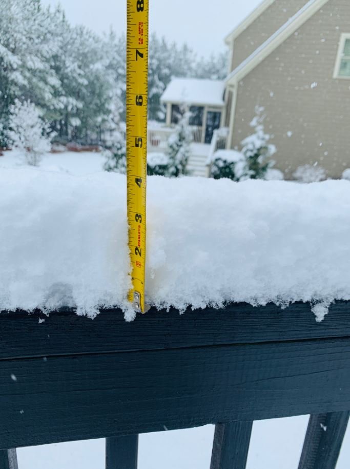
WOOOOO WEEEEE what a day! I love a surprise over performer. This only got picked up by the NAM Thursday and there was so much doubt about how it would perform or if it would even happen. What a great 4 hour storm! Kids got to build snow men, sled and have a bunch of fun. Currently the fog is TERRIBLE and I am wondering about freezing fog later tonight. Here are some pics from today.

-
7
-
 3
3
-
-
8 minutes ago, lilj4425 said:
I’m at 28 degrees. Well, somebody is going to be wrong today.


For sure.
Looking at temperature panels, those are a big bust for this morning. Again, not sure what that will mean down stream.
Also, moisture on radar is not reaching the ground in Alabama so let the virga storm begin. LOL -
What is interesting is the moisture falling right now in Alabama is not on any of the maps at this hour. The HRRR and the NAM are all too slow by 3-4 hours for the development of moisture. My temp at my house is 4 degrees below forecast and even as I type this is falling.
I am not sure what it will mean downstream for snow development but I can say with a lot of confidence the model guidance at this hour does not match up on timing and the moisture is more robust than modeled. -
It can when it looks like this.
The line of disappointment will be sharp today in GA.
-
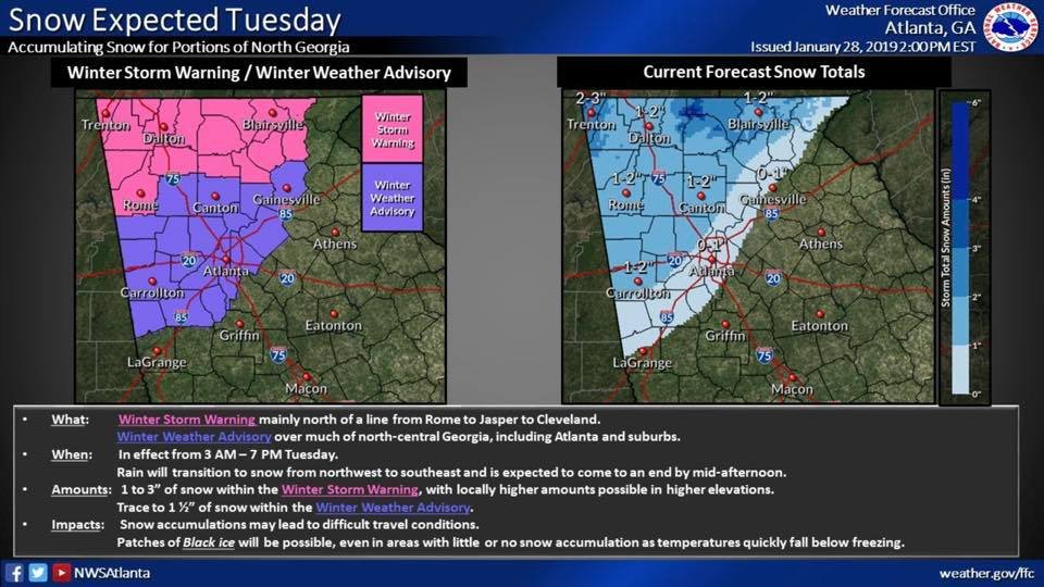
Winter Storm Warning up for NE GA counties. I am one county out of the game but pretty excited that my forecasted temp is currently 4 degrees colder and rain is ahead of schedule in Alabama.
-
This 18Z Run of the NAM is the juiciest so far for North GA.
-
Let's ride.
-
2
-
-
1 minute ago, LithiaWx said:
Upper levels will be pretty cold. That’s why don’t sleep on it.
LOL... Not holding my breath. This pattern is awful.
-
2 hours ago, mackerel_sky said:
Don’t sleep on the 7th! GFS is still interesting on 12z! Cold looks about as good as we can get, moisture is around...
What am I missing? Moisture looks anemic. Thats the coldest 2mm temps I could find and those only last for 3 hours.
-
1 minute ago, NYweatherguy said:
If this is accurate, those of us in Gwinnett County get screwed.....again.
I wasn't expecting ANYTHING. We are too far East for these setups. Very similar to 2014. We got nothing and Cobb County folks couldn't make it home.
-
Here is the disco from FFC. Good nuggets in here as to their thinking.
National Weather Service Peachtree City GA
243 PM EST Mon Jan 28 2019

.SHORT TERM /Tonight through Tuesday Night/...
Main concern is likelihood and timing of rain/snow and snow Tuesday
and will there be impacts from black ice late Tuesday afternoon and
evening. 12Z guidance still brings broad clipper system through
quickly. Even with good agreement on precip timing, of all things,
there is quite a disparity in model temps as the round of precip
moves through. Of course the statistical guidance and any blends
that use them were thrown out due to poor performance with fronts
with such strong gradients. Used CMC, HIRESWarw, local WRF and some
other raw model guidance. EC raw grids too course temporally to use
in GFE, but also shows cooler sfc temps. GFS and NAM have continued
trend of slightly warmer sfc temps. These temps are key to produce
changeover to snow during a relatively short window of time. In
downtown Atlanta, changeover should occur around 9-10a before ending
around noon-1p. Some of the hires guidance pushes things out even
faster than this. Based on all this, local tools producing very
similar snow amounts as WPC guidance which shows snow amounts < 2
inches with the < 1 inch line about 10-20mi north of the
Chattahoochee river and the line of no snow down to just south of
I-85. To account for some uncertainty, have pushed the no snow
line an additional 10-20mi south and east and based advisory on
this. Some question whether temps will be cold enough in Troup Co
(temps never go below 36F until well after precip ends), so have
left them out for now. Higher amounts of > 2 inches likely to
occur in higher elevation of far north GA but would not be
surprised to see those amounts even in Rome or other parts of NW
GA.

Another concern is refreezing of liquid around and after sunset as
temps fall below 30F. Total liquid equivalent precip only expected
to be 0.15 to 0.25 inches across northwest 1/2 of state with lesser
amounts to the southeast. If we get enough sunshine and winds in the
afternoon, the chance for refreezing is low, however there is
uncertainty. Also, sheltered areas can see much less wind and
evaporation and can also see additional runoff and seepage of water
from nearby grounds.

Tuesday night should be windy and much colder and continued cold for
Wednesday.
-
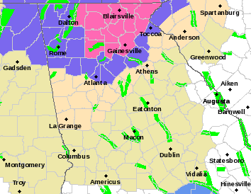
Winter Storm Warning up for parts of N GA.
-
18Z NAM just dried up. Even in Alabama wow. That is no bueno.


Mid to Long Range Discussion ~ 2024
in Southeastern States
Posted
Looks like the NW Georgia Peeps could cash in along with people in the Tennessee Valley that struggle many times to score. If the HI-RES EURO is right, more people in NW Georgia and North Georgia could score.