

OKpowdah
-
Posts
6,036 -
Joined
-
Last visited
Content Type
Profiles
Blogs
Forums
American Weather
Media Demo
Store
Gallery
Posts posted by OKpowdah
-
-
Is Keene going to pull off another day with excessive heat criteria? From 80F dews lol
-
 1
1
-
-
2 minutes ago, Baroclinic Zone said:
How the hell are ya Sam?!
https://mesowest.utah.edu/cgi-bin/droman/mesomap.cgi?state=MA&rawsflag=3
This works, thanks!! Just wanting to get a look at that sea breeze temp gradient. Damn!
I'm currently hiding away from the heat of Oklahoma (and New Hampshire) up in Michigan for a little while -
Anyone have the link for that page with the temperature mesonet map in southern New England? It's been a while
")
-
26 minutes ago, dendrite said:
I was looking at BGM. Is that for GYX? Link? I've been looking for their criteria page.
https://www.weather.gov/bgm/heat
I think some criteria changed earlier this year, but I can find the info on it. BTW...last hour yielded a 104F HX so technically GYX could say that hour didn't verify.
That's for BOX. Not sure if GYX has a page.
Sorry here's the link I used https://www.weather.gov/box/criteria -
2 minutes ago, dendrite said:
I'm guessing they didn't expect today to be so humid? Criteria is 2 consecutive days with at least 3 hours of 105F+ IIRC.
2 hours >=105F
Heat advisory requires 2 days, and the southern CWAs require 2 days for EHW.
My thing is after observing yesterday, and then seeing the same dew points by noon today, pull the trigger. I mean they put up the warning at 2:37pm yesterday, after already 2 hours of EH criteria met. So late it's basically worthless. Waiting to see how high dew points got today is understandable. See it, then act.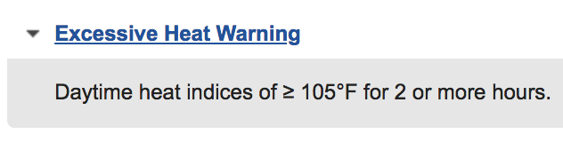
-
And 4pm obs put Keene at 105F heat index. 2 hours of HI>=105F and excessive heat criteria. No warning.
-
Keene again with one of the highest heat index in the entire region.
And no Excessive Heat Warning.
Also the point forecasts are down, and only zones showing up right now.
Is all of the Gray NWS drinking margaritas at the pool?-
1
-
 2
2
-
-
1 hour ago, Damage In Tolland said:
Why so angry?
Heat index up to 102F at noon.
And no warning.
After yesterday, this is just incompetence. -
Alright I need Gray NWS to step up here. WTF. Yesterday it took until 2:37pm to pull the trigger on an excessive heat warning in Keene. Heat index had already been 105F+ for 2 hours at that point.
Now it's already 89/73 = HI of 97F before noon. Where's the EHW? This will be one of the most obvious situations for a EHW in NH of the last few decades, and they're dropping the ball. -
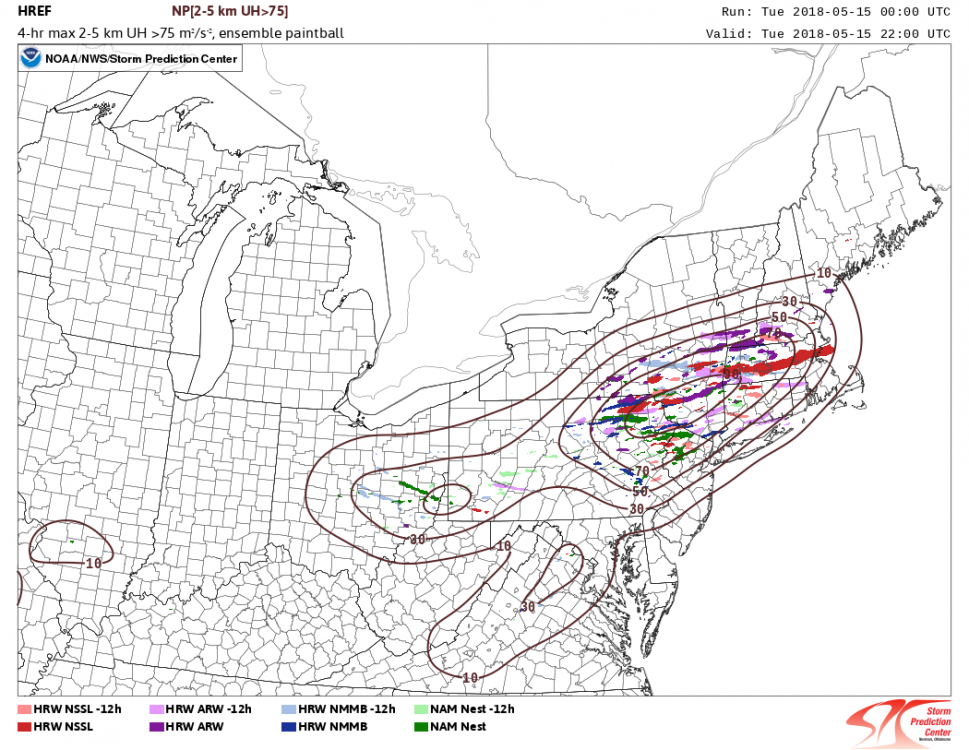
This is a pretty telling picture. Strong agreement among the CAMs like you said. Widespread severe event looks likely.
-
3
-
-
Just now, radarman said:
0-1" of snow on the ground going in
3" new
8" more to go apparently

-
2 minutes ago, mostman said:
Lol.
Maybe they were *forecasting* snow including what's on the ground in Amherst...?
-
Figured this still would go in this thread...
Lots of fun tomorrow too. Upstream ML low drops over the Northeast, 500mb temps plummet to around -35C. There's no low level cold advection going on behind this storm. Plus low to mid level moisture gets trapped in the broad circulation formed. We're talking total totals >50, even potentially some low level CAPE >100J/kg.
Recipe for heavy snow squalls with whiteout conditions, maybe some thunder..thumb.png.51accb2c750caf820ceac642116664c3.png)
-
2
-
-
3 minutes ago, ORH_wxman said:
It wouldn't surprise me if there were an inch or two tonight from that. The ULL goes right over head too which will help with the snow shower activity.
The upper low is going to give you guys some fun for sure. Especially tomorrow. I mean you even have surface based CAPE tomorrow afternoon. Good recipe for squalls with whiteout conditions.
-
Parents back in Keene, NH reporting 3.5" total so far
-
For the sake of my own mental health, I'm so happy I'm living in Oklahoma right now.
Because if I was back in Keene, NH for the moats in these past two storms .....-
2
-
-
The fgen band already overperforming as it is, if the elevated isothermal layer can cool just like a degree more, someone in SE MA is guaranteed 30" with prolonged 3-4/hr rates. Other guarantee is someone just W of this mega-band, and east of some western edge banding, is getting screwed.
-
1
-
 1
1
-
-
Shallow convection. Actually have a little bit of CAPE in the lowest couple kilometers. HRRR has this in the forecast too.
.thumb.png.20d5bce6e7759995f186febc977e9ac6.png)
-
2
-
-
2 minutes ago, Ginx snewx said:
5 possible opportunities for deep deep BM area cyclones has produced 3 epic storms, historic really.
Beginning with the early January bomb and going forward, the last 2 and half months have delivered a very impressive frequency of rapid deepening and deep cyclones inside 65W, and even more remarkably, south of 40N. I mean multiple sub-970 xtrop lows inside 40/65 in a couple months. Amazing.
-
1 minute ago, dryslot said:
I mentioned your name the other day that your snow maps use to give rise to many..................
lol I was tempted to make a map for this storm. I'm sure the snowfall distribution will be as phallic as ever.
-
2
-
-
6 minutes ago, ORH_wxman said:
DST really sucks. Totally useless this early in the year.
00z RPM out to 2 hours. Gonna be a long hour of waiting...sans the brief interruption where metfan tells us the 21z srefs look good.
DST is EXTREMELY useful now! We need every minute of evening daylight we can get for chasing
Prospects of epic banding over eastern New England brought me here to watch y'all get hyped up! What a stretch.-
2
-
-
Following the recurvature of Typhoon Francisco, we get a huge jet amplification again in the West Pacific, and it looks like both the GFS and ECMWF want to develop an intense low in the poleward exit region by day 7-10. Could get kinda windy around the Aleutians to western Alaska.
-
Ahhh I want to be back up there! Great pics man!
-
Aurora forecast for this weekend! Too bad we're counting on darkness and clear skies ... both of which may be difficult to come by http://www.gi.alaska.edu/AuroraForecast/Alaska/2012/07/14
.png.97aa115364742253434c828acaf4f707.png)
.png.ce331e14ffe564bbc46ba85212bc1afd.png)
July Doldrums - Summer in full effect Pattern and Model Discussion
in New England
Posted
Truth.
Though 07-8 and 08-9 were the nickel and dime paloozas that left me really missing blockbuster storms.