
homedis
-
Posts
745 -
Joined
-
Last visited
Content Type
Profiles
Blogs
Forums
American Weather
Media Demo
Store
Gallery
Posts posted by homedis
-
-
This is some real nice SN, big flakes stacking up -- grass should be covered shortly. A little surprised how fast that transition to snow went being just 4 miles from the lake.
-
Just changed to mostly snow here in Deerfield.
-
Wind driven rain in Deerfield. Curious to see what will fall under the heavy returns about to come overhead.
-
Yeah its all rain and slush here in the loop area. About to make the drive to Deerfield, curious if they’re the same since it’s also a few miles from the lake (although a bit north of the city).
-
You’re 15 or so miles from the lake vs. my 5. You’ll do much better than I.
1.2 miles here. Im gonna get all rain, arent I? -
See below post, good info for the mechanics of the rain to snow transition (for Urbana-Champaign but applicable to most areas):
https://x.com/vortexjeff/status/1744480403405050115?s=46-
 2
2
-
 1
1
-
-
Liking the trends so far, a slightly weaker low would produce a more spread the wealth situation in N IL it seems. As long as we can avoid rain here in Chicago, I'll be happy (famous last words).
-
1
-
-
Downtown chicago here… beating a dead horse but would much rather be on the northern fringe than the southern fringe of the defo axis for this one, especially with the warm lake. This one’s either gonna be nothing or a nice 5-6” imo.
-
Entire region getting rocked and we haven't even seen a flicker of lightning in Madison yet...looks like the HRRR was kinda right. That northern complex should at least clip us, though.
Getting some light showers downtown lol -
2 minutes ago, A-L-E-K said:
Low grade mammies from the miss sw
Gotta love to hate the lake
-
1
-
-
1 minute ago, sbnwx85 said:
Hatched wind area on the latest outlook. Not sure if it was there before.
It wasnt. Yeah this things gonna ride the instability gradient just to the south of Chicago. Kankakee special
")
-
1
-
-
it would become elevated over the surface inversion. if it was well formed it would still be able to punch through the cool layer and bring strong winds to the surface
“Cool layer” I can barely breathe downtown Chicago right now its still 86/75 -

Lots of clearing coming - I have a good feeling about today.
-
2
-
-
At 6:23 saw the end of the Stickney cell
https://imgur.com/a/fZAieiG -
4 minutes ago, SchaumburgStormer said:
Yeah nothing looking to impressive or explosive yet
Agreed, but I think its only a matter of when & where the storms interact with that warm front and instability that is heading northwards.
-
Clouds thinning out already in loop area. I usually have no faith in strong severe after atmosphere mixing and stabilization this late in the day, but will be interested to see if SPC/forecast models are onto something.
-
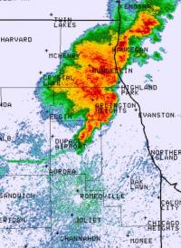
Warned for 90 mph Kendall and Kane Counties in IL
-
There's no way this last line can miss Chicago now... right? right??
Unless we get the I-39 special where the line hits a wall

-
Downtown Chicago in the screwhole for round 1

-
 1
1
-
-
Getting a little concerned for Peoria based on the hook developing on that cell.
-
Tornado warnings starting to pop up now... here we go
-
Just measured 65/51 in downtown Chicago, this is definitely overperforming versus what the models were predicting.
-
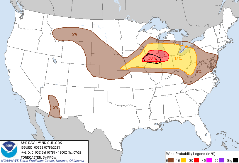
Seems like SPC either doesnt like far NE IL for sig. wind/tornadoes or is deliberately trying to avoid showing the moderate risk over the lake

And with NE storm motion (not SE) the boundaries seem a bit confusing to me.
-
1
-
-
Interesting that the MO storms seem to have fizzled out/coverage is less than modeled.
Jan 11-13th Blizzard
in Lakes/Ohio Valley
Posted
This is looking like the real deal for Chicago, of course after I just left town for the next week.