

SnOvechkin
-
Posts
29 -
Joined
-
Last visited
Content Type
Profiles
Blogs
Forums
American Weather
Media Demo
Store
Gallery
Posts posted by SnOvechkin
-
-
40 minutes ago, beavis1729 said:
 This is comical.
30-40 years ago, Dec. 2022's average temp of 29.1F would have generated a departure of roughly +2 to +3...as ORD's normals have gone up significantly over the past generation. This was not a cold December. 23 days had highs of 30F+, and 14 days had highs of 40F+. That is not even close to being wintry...yet somehow it's a below normal month??? Just ridiculous in so many ways; this is Exhbiit A (among hundreds of other examples) of how bad our winter climo is. December has the shortest days of the year, yet almost half the days in Dec. 2022 were in the 40s or warmer.
Besides the 3-4 cold days around Christmas, the rest of the month was a torch.
I actually agree with cromartie on this one...probably for the first (and only) time in history.
It was brutally cold for the entire last week of December. Literally as cold as it can get, for days on end. The short December days don't cause cold days in December - they cause the cold days of January-March. It's called seasonal temperature lag. And it's Meteorology 101. We just went through a sunspot cycle. It cycled towards warmth. Now it's going to cycle back towards cold weather. If you think that the average temperature between extremes is the "normal" temperature you're living in a fantasy world.
That was a cold December. And for many of us, it snowed over and over again. I stopped counting a couple weeks ago when we hit 12 days with snowfall here in north-central Indiana. It's probably more like 15-16 now.
And winter is, at a maximum, only 1/3 of the way through. Chill out. -
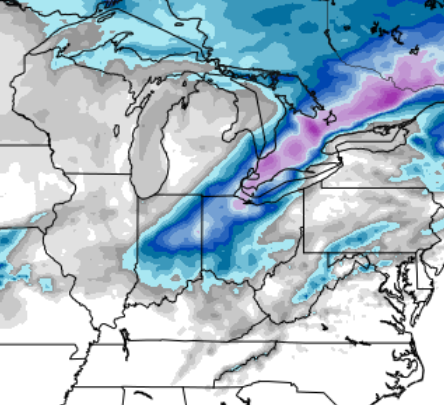
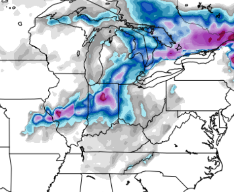
The GFS has consistently shown an Indiana into Ohio snowstorm for Thursday night and the Euro now agrees. Where is the thread? Where is the discussion at all? GFS drops up to 20" at 10:1. Obviously much less would accumulate with the warm surface, but we are talking about 1-2" per hour for 12 hours; This would be a major storm and the Euro now also shows a deep Low over OH on Friday morning
Winter 2022/23 Short/Medium Range Discussion
in Lakes/Ohio Valley
Posted
And I argue that waiting for the Euro to show something is foolish. GFS has been the best performer this year medium range AINEC. (In terms of showing a threat... obviously none of them can nail details that far out, with all the cLiMaTe ChAnGe nonsense with which they're programmed)