

palmettoweather
-
Posts
121 -
Joined
-
Last visited
Content Type
Profiles
Blogs
Forums
American Weather
Media Demo
Store
Gallery
Posts posted by palmettoweather
-
-
26 minutes ago, PantherJustin said:
I’m sorry…. I get setups ect….. but no way Florence gets a foot …. Look at the setup and some of the areas forecast to recieve even a few inches Myrtle/Wilmington think of how rare this would be….. historically this outcome is near impossible imo
https://www.weather.gov/ilm/ChristmasSnow1989
It's rare, but growing up in the Pee Dee, it is definitely not impossible.
-
 2
2
-
-
2 hours ago, Iceagewhereartthou said:
Can anyone find a list of totals? Looks like GSP got just an inch.
https://nwschat.weather.gov/p.php?pid=202102071609-KGSP-NOUS42-PNSGSP
-
 1
1
-
-
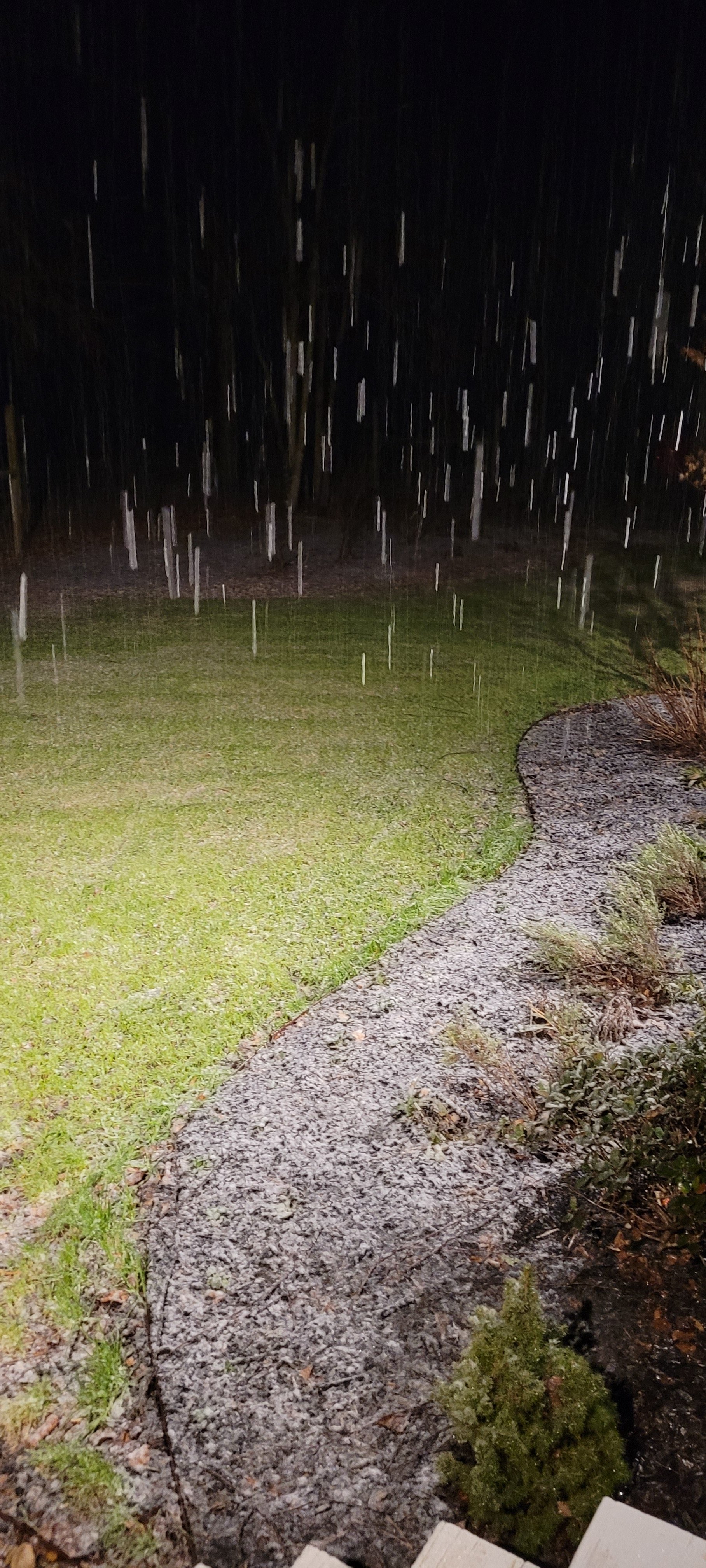
Good flakes here outside of Pendleton (extreme Northern Anderson county near Central) , looks to be the end of the show with the warm nose creeping this way and precip ending.
Never will complain about a surprise 2" snowfall in the South though. I hope a lot more people get to see some snow out of this, pulling for you.
-
1
-
-
-
Mostly snow/sleet in Pendleton. Ground turning white. Have to give Bull and Burrel credit, I was pretty cynical on HRRR. Already below temp I was supposed to be tonight. 32.9/32.1
-
3
-
-
35.1/33.8, flakes mixing in here.
-
Well temp is down to 40.5/35.4 here outside of Pendleton. Definitely crashed 6 degrees in the last 30 minutes due to evaporative cooling, but rate driven event will have to take it from here. Still hope HRRR knows something.
-
1 minute ago, SnowDawg said:
Not good boys...Even the NAM is underestimating the strength of the warm nose apparently.
special 18z sounding from KFFC shows a
stronger warm nose than what any of the models depict, but the NAM
is closest. How far this warm nose works north and west, into the
area where temps are closest to or below freezing, will determine
the extent of the wintry precip.
They dropped my totals for the 3rd time today and only give me a single hour of all snow and transition to all rain by 11....

I'll never doubt the NAM again. HRRR is fool's gold, hope I'm wrong. Hard to doubt what it is seeing in regards to thermals.
-
34/27 in Pendleton, clouds have moved in. Hoping burrel reels us one in indeed!
-
15 minutes ago, Avdave said:
This is how this season would go, you get a good pasting an all the way down to Savannah, GA gets snow and its cloudy and cold in the triangle.

Looks like a Palmetto state special

If it has a warm bubble all the way into NE GA and the Western Upstate, you can count on it...
-
5 minutes ago, TARHEELPROGRAMMER88 said:
Question, is which is more accurate at this range at predicting moisture envelope?
As one of the mets posted on here the other day, the 12 km NAM is usually pretty goofy with its surface depiction. It is bad about displaying widespread QPF as one consistent mass. The 3km is higher resolution and it is usually has a reasonably accurate depiction of reflectivity in that there will be bands, not one continuous mass of precipitation in this system.
-
 1
1
-
-
5 minutes ago, Buckethead said:
Woke up to 16° and light to moderate snow still falling. 8" on the ground is a great start to the season!


Sent from my SM-G970U using Tapatalk
Man that's awesome, happy for y'all in the mountains getting some snow! Hopefully that bodes well for the rest of the Southeast.
-
1
-
-
11 minutes ago, Orangeburgwx said:
Short vid I made:
Sent from my LML212VL using Tapatalk
Happy to see you got some snow man, that's awesome!
-
1
-
-
Just now, oconeexman said:
Same here..best flakes yet and I'd say 60/40 snow
Big flakes here as well now, but still 37. Not gonna stick like 2/8.
-
Finally some flakes mixing in with heavier returns NE of Pendleton, 38.
-
1
-
1
-
-
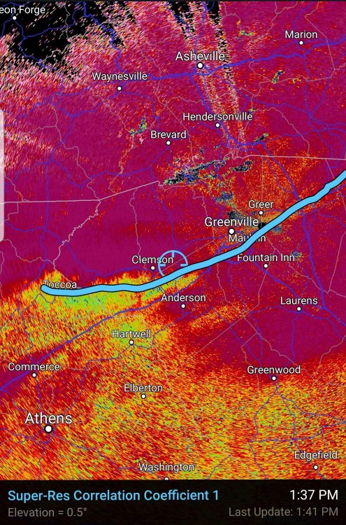
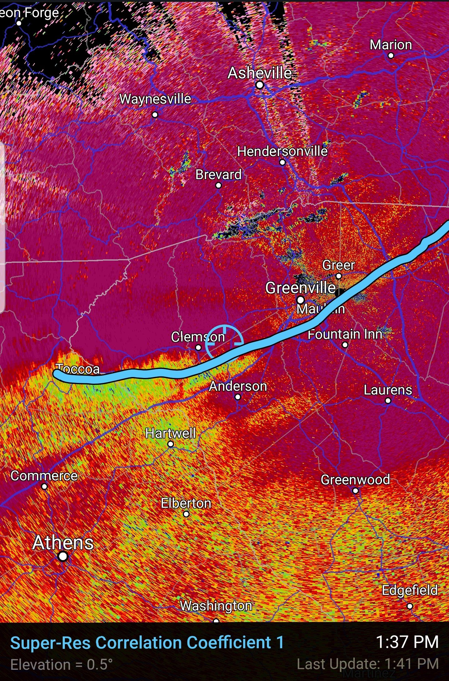
10 minutes ago, SnowDeac said:
I feel like 10+ people have asked (including me already), but can someone link the CC radar? Can't find it on the GSP site, and don't have it bookmarked anymore.
I can't find you a page that quickly, but you are looking for Correlation Coefficient.
It's usually dead on, however, I'm North of it in Pendleton/Central and I'm rain/sleet. Too warm at the surface I guess, and tricked CC.
Edit: I'm using app on Android, RadarScope, but I believe it is a one time pay product.
-
48/32 E of Pendleton, SC
-
12 minutes ago, Extreme NEGA said:
Hug the HRW-ARW model
It folded on NE GA and the Upstate for the most part as well, moving toward the warm nose that NAM sniffed out way before.
I was looking too, but alas, here's to a nowcast miracle in GA and Upstate.
-
6 minutes ago, burrel2 said:
FYI, the RAP is similar to the HRRR in that it has no warm nose above i-85 at 10am tomorrow morning.

Yeah, there is a 5 degree C difference at 825 mb between the 3K NAM and the HRRR/RAP at my place. There may be hope, even though asking for the HRRR/RAP to verify upstairs and the 3K NAM to verify at the surface seems like a stretch.
-
9 minutes ago, dorkchopper said:
Sorry for the annoying question (I promise I'll go back to lurking like I have been for the past 9 years).
What's the timeframe for this in the Durham area? I haven't seen it really posted anywhere, and if it has been, I overlooked it and I apolize.
Thank y'all for being so informative and fun to read.

That hasn't been nailed down, but we will for this exercise, assume the 3K NAM is close. This is the first panel that shows precip of a heavy nature over Durham. If you read the valid (not the init or initialization) on any of these forecast maps, it will tell you the time (this one 18Z), then subtract 5 hours for EST (these maps are all in UTC). So this would suggest this scenario pictured unfolding at 1300 or 1 PM on Thursday.
-
3
-
-
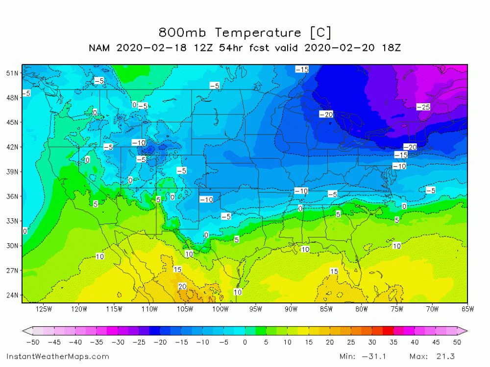
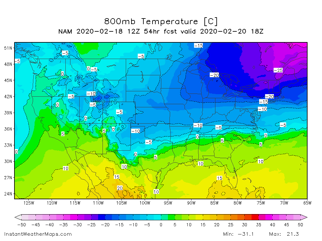
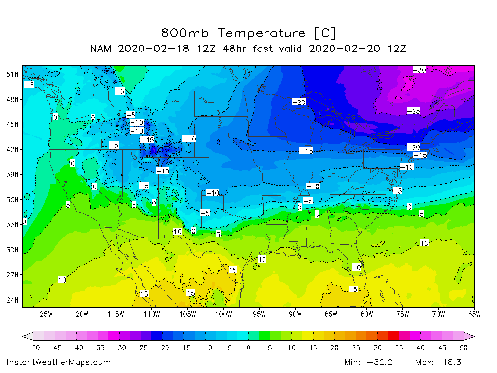
14 minutes ago, palmettoweather said:
Start of event for Upstate
Hour 54, roughly middle of event for Upstate SC, WNC
-
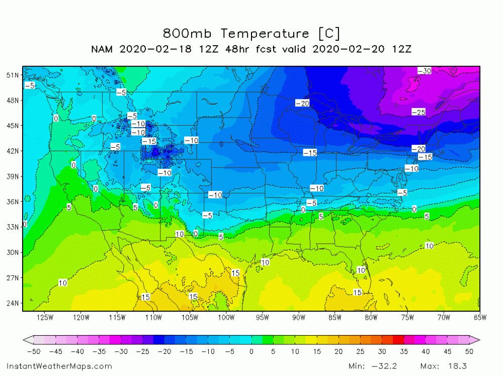
18 minutes ago, burrel2 said:
Anybody know where to get an 800mb temp map from the nam? That would show the warm nose much better.
Start of event for Upstate (corrected, should have been hr48 for 12z).
-
1
-
-
2 minutes ago, BornAgain13 said:
Use the 12k, its resolution is higher..
Other way, 3KM resolution is higher. Think about it as that it can resolve down to 3KM "blocks."
-
1
-
1
-
-
Just as an observation from a few previous winters, the 12K NAM's surface output often seems a bit odd and tends to overdo the QPF in quantity and spread it out over a massive region. I've hunted verification scores at 500 and surface between the different resolutions of the NAM, but I have not found any. 3KM NAM should give us more clarity once it is in range, I'm wary of this 12KM output.

NW Trend For the Win! (1/21-1/22 2022 storm) Obs Thread
in Southeastern States
Posted
Glad to see so many people get to enjoy snow, including the RDU, E NC and the Midlands/Pee Dee of SC. Hope we all have one more!