

Travisstorma
-
Posts
23 -
Joined
-
Last visited
Content Type
Profiles
Blogs
Forums
American Weather
Media Demo
Store
Gallery
Posts posted by Travisstorma
-
-
I’ll take that!
. -
Looking good in Broken Arrow!

.-
 1
1
-
-
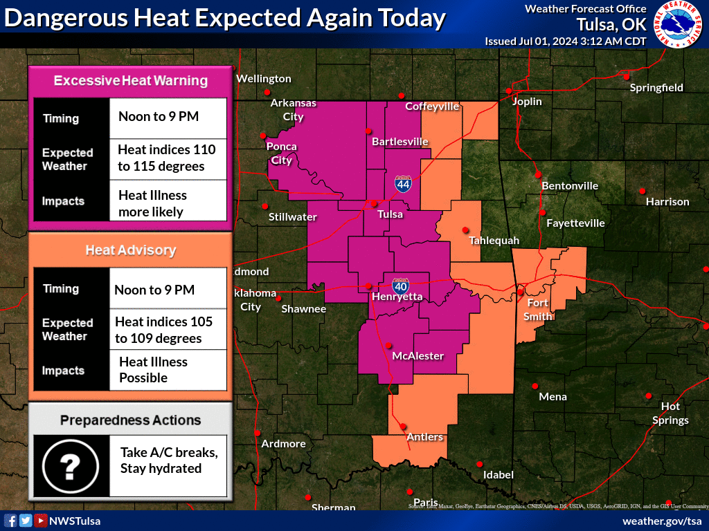
Probably will be sunny in Tulsa now since they put this map out.
-
Just now, DanLarsen34 said:
Think they need to pull the trigger on a tornado emergency. This thing is over a mile wide based on what I just saw from a chaser on twitter.
Now issued.
-
A couple of my phone shots from south of Mangum.


.-
 12
12
-
3
-
-
They weren't when I was in school.
-
Pictures I took of tornado about six miles north of Wagoner,OK.


.-
3
-
-
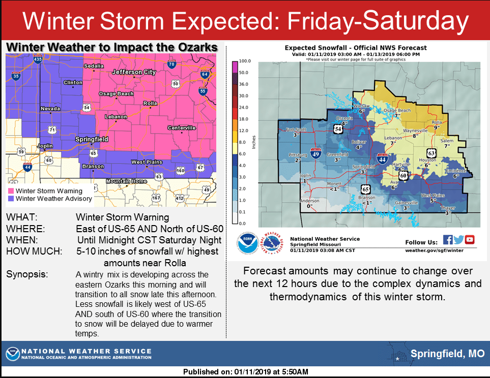
43 days would put it at Jan 13th, 2019. That map just shows the number of days since the NWS office's responsibility area was in winter storm warning.
-
I raced home to beat that storm the day before it happened...
It was fun driving around town looking at all the people in minivans stuck in the snow. My truck sits high off the ground and was still hitting the snow with the bumper in areas. I'd love for that to happen again...
-
1
-
-
Listening to OHP right now on the scanner and I know they are working multiple multi-car crashes right now.
-
Probably jinxing us here now..

744
FXUS64 KTSA 012111
AFDTSA

Area Forecast Discussion
National Weather Service Tulsa OK
311 PM CST Sat Dec 1 2018

.DISCUSSION...

The main forecast concern will be winter weather potential late
next week/weekend.

Deep cyclonic flow over much of the CONUS will maintain below
average temps thru the first part of next week. After a brief
period of modification next week, the weather will be taking a
downward trend toward the latter part of next week and into next
weekend.

The broad upper trough over the CONUS, carved out by the strong
upper jet that helped bring the severe weather last night, slides
east by midweek, and the upstream split flow pattern over the
eastern Pacific will be broken down by jet stream energy to its
west. A shortwave trough in the southern stream will advance east
across the southern tier of states late next week and weekend,
throwing a slug of moisture over the region. Coincidentally,
northern stream trough energy is expected to drop southeast out of
Canada, forcing surface high pressure and cold air south thru the
Plains. This one-two punch will bring the potential for wintry
weather, possibly significant, by next weekend. The operational
GFS is the warmest of all the solutions and is generally not
favored with its poor handling of cold air. The ECMWF and GFS-FV3,
while they differ in timing and the details, both show the idea
of a southern stream storm moving by to our south with wintry
weather occurring over at least a portion of the forecast area.
The details will continue to be ironed out in the coming days.
Stay tuned.

Lacy
-
3
-
-
My WX station has been teetering between 32 and 33 here on the SE side of Broken Arrow. Had some sleet for a few minutes a couple hours ago.
MO/KS/AR/OK 2021-2022 Winter Discussion
in Central/Western States
Posted
Wow. Can’t recall I’ve ever seen white on that graphic!
.