

knowledgeispwr
-
Posts
95 -
Joined
-
Last visited
Content Type
Profiles
Blogs
Forums
American Weather
Media Demo
Store
Gallery
Posts posted by knowledgeispwr
-
-
51 minutes ago, Tullioz said:
Higher SSTs may be more of an asset than a liability when it comes to winter storms along the east coast.
Climate Change and Extreme Snow in the U.S.
Conditions that influence the severity of eastern U.S. snowstorms include warmer-than-average ocean surface temperatures in the Atlantic. These can lead to exceptionally high amounts of moisture flowing into a storm and contribute to greater intensification of the storm. Unusually high ocean surface temperatures in the Atlantic were a contributing factor to the February 5–6, 2010, snowstorm dubbed “snowmaggedon” that hit Washington, DC, with 17.8 inches of snow at Reagan National Airport—the fourth highest total storm amount for the city at the time.
Also, some recent research has shown that increasing surface temperatures and reductions in Arctic sea ice may produce atmospheric circulation patterns that are favorable for winter storm development in the eastern United States.
In addition, studies have shown that natural variability associated with the presence of El Niño conditions has a strong influence on the incidence of severe snowstorms in the eastern United States. Based on an analysis of the top 100 snowstorms in six regions east of the Rocky Mountains, scientists found that severe snowstorms are approximately twice as likely to occur in the Northeast and Southeast regions during years when a moderate to strong El Niño is present as compared to years when neutral conditions exist.
I wonder though how much warmer Atlantic SST actually help for snowstorms south of northern and central VA.
4 hours ago, Northern Foothills Snowman said:So we just throw in the towel in the 3rd quarter.
I suppose nobody remembers March 93.
This was before my time but any remember hearing about March 1960 snowing every WednesdayIt stayed cold and the snow didn’t melt. That winter was mild and the first snow didn’t fall until February.
Just saying just like the Super Bowl Patriots vs Atlanta. It wasn’t over at 1/2 time.
Our forecast tools are much better now than during the time periods you mentioned.
-
 1
1
-
-
1 hour ago, NorthHillsWx said:
If this upcoming ~2 weeks pattern doesn’t produce outside the mountains/foothills somewhere, I think there will be some serious questioning as to whether or not it can snow here anymore
The climate trends our not our friends for those us east of the high terrain. Fingers crossed though!
-
~0.75” 5.8 SW of Winston-Salem city center.

-
 1
1
-
-
Finished with 0.5" in SW Winston-Salem. I was basically expecting zip, so I'm glad I got to see some more snow. Congrats to all y'all south and east seeing much more than y'all typically do!
-
3.5" of snow and sleet in SW Winston-Salem. Currently some very light freezing drizzle. 27.5F
-
2
-
-
22.8F, very blustery, ~2" of dense sleet and snow in SW Winston-Salem.
-
21.7/18.2 now almost all sleet. SW Winston-Salem. ~1.5" of snow before the changeover.
-
22.1/18.8, Mod-heavy snow...SW Winston-Salem
-
32.9/17.2 SW Winston-Salem
-
Almost 3” in SW Winston-Salem. Still snowing heavily.
-
3
-
-
The wind—something that wasn’t an issue during this past weekend’s event—will more than make up for any slightly reduced ice accretion that might happen.
That and the soil in most places is very saturated. -
Here in SW Winston-Salem, just south of 40, while we did dip below freezing last night, it wasn’t enough to cause issues. Everything here was just wet with no noticeable ice on trees or surfaces.
-
Just now, NorthHillsWx said:
High Wind warning now up for the Triangle with gusts to 60 mph possible. What changed? More efficient mixing of winds to surface with daytime heating? Not seeing any wind reports near that downstream of us in Raleigh
Charlotte reported a gust to 58mph at 9:25am.
-
2 minutes ago, JoshM said:
68 right over MBY, going to be a fun morning
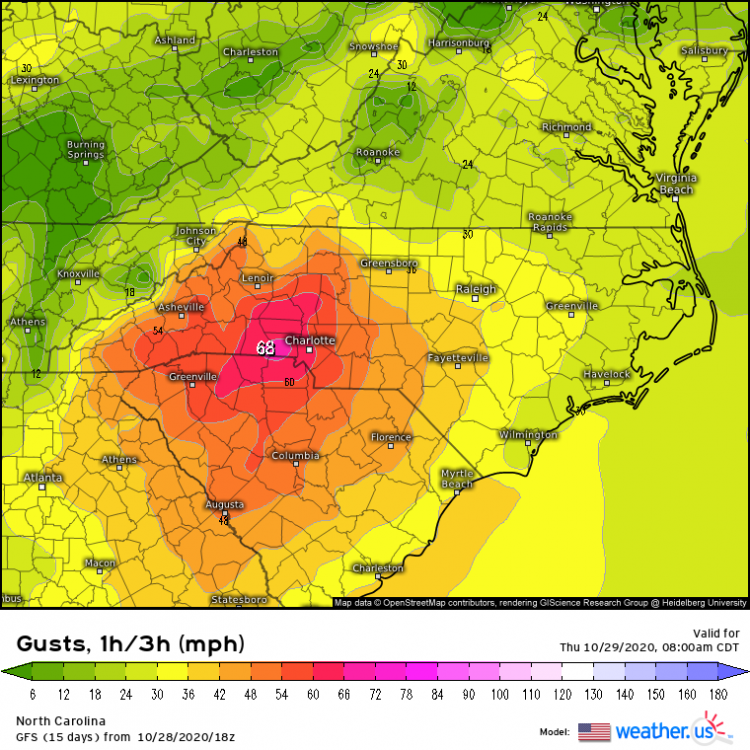
Euro gust maps tend to be quite overdone. Is the same true for GFS ones?
-
I've gotten 0.64" so far from this first rain band here in SW Winston-Salem. I got 0.21" early this morning from precip associated with the front.
-
2.09" event total so far in SW Winston-Salem.
-
In southwest Winston-Salem, 0.75” so far this morning, 6.85” for February and 12.51” for the year so far.
-
Storm total rain for southwest Winston-Salem: 4.77”.
Wow.
And a wind advisory issued. A gust of 53 mph was recently measured at PTI:
Wind AdvisoryURGENT - WEATHER MESSAGENational Weather Service Raleigh NC443 AM EST Fri Feb 7 2020...Unusually strong, high impact wind event expected acrosscentral NC early today....A rapidly strengthening area of low pressure will tracknortheastward across the middle Atlantic states today. A trailingcold front will sweep east across central NC this morning, withfollowing very strong southwesterly wind that will overspread theregion.NCZ007>011-021>028-038>043-073>078-083>086-088-089-072100-/O.CON.KRAH.WI.Y.0001.200207T1000Z-200207T2100Z/Person-Granville-Vance-Warren-Halifax-Forsyth-Guilford-Alamance-Orange-Durham-Franklin-Nash-Edgecombe-Davidson-Randolph-Chatham-Wake-Johnston-Wilson-Stanly-Montgomery-Moore-Lee-Harnett-Wayne-Anson-Richmond-Scotland-Hoke-Cumberland-Sampson-Including the cities of Roxboro, Oxford, Creedmoor, Henderson,Kittrell, Warrenton, Norlina, Roanoke Rapids, Enfield,Scotland Neck, Winston-Salem, Greensboro, High Point, Burlington,Graham, Mebane, Hillsborough, Chapel Hill, Carrboro, Durham,Rougemont, Louisburg, Franklinton, Nashville, Spring Hope,Rocky Mount, Tarboro, Princeville, Lexington, Thomasville,Asheboro, Archdale, Siler City, Pittsboro, Raleigh, Cary, Apex,Wake Forest, Knightdale, Smithfield, Selma, Clayton, Wilson,Albemarle, Troy, Southern Pines, Pinehurst, Aberdeen, Carthage,Sanford, Lillington, Angier, Buies Creek, Erwin, Dunn, Goldsboro,Wadesboro, Polkton, Rockingham, Ellerbe, Laurinburg,Camp Mackall, Wagram, Raeford, Fayetteville, Spring Lake,Hope Mills, Clinton, and Roseboro443 AM EST Fri Feb 7 2020...WIND ADVISORY REMAINS IN EFFECT UNTIL 4 PM EST THISAFTERNOON...* WHAT...Winds will become southwesterly and increase to between 15 and 30 mph, with frequent gusts between 35 and 45 mph. Infrequent gusts in excess of 50 mph will be possible, especially across the Sandhills and Coastal Plain, from Laurinburg to Fayetteville to Goldsboro and Rocky Mount.* WHERE...All of central North Carolina.* WHEN...The Advisory is in effect from 5 AM to 4 PM EST today. The strongest wind will occur between 6 or 7 AM and noon or 1 PM.* IMPACTS...Significant tree damage, including falling limbs and branches, and scattered to numerous uprooted trees, will result, as will numerous power outages.* ADDITIONAL DETAILS...Given that this is expected to be an unusually strong wind event, and soil is saturated from multiple inches of soaking rain during the past 48 hours, scattered to numerous uprooted trees may result.PRECAUTIONARY/PREPAREDNESS ACTIONS...Travel and outdoor activities are strongly discouraged thismorning due to the strong wind gusts and increased risk of treedamage.&&
-
4.25 of rain so far. Dont remember the last time I've seen gsp and ffc issue so many flash flood warnings.
I wonder when was the last time there was such a wide spread severe weather AND flooding event during the winter months in the southeast.
4.32” storm total for southwest Winston-Salem. -
Forward progression seems to be temporarily halted at the Wake/JoCo line. Still dry here in Clayton.
I also noticed the forward progression has really slowed based on the radar.
Storm total 3.81” in southwest Winston-Salem. -
Storm total 3.56” in SW Winston-Salem and still getting rumbles of thunder.
-
1
-
-
Moderate sleet shower in SW Winston. 38.5F/24.2F (KINT reported a dewpoint of 18F at 2:54 according to the NWS).
-
Just now, Cheers for Western Ears said:
When do you guys suppose they will start issuing advisories and warnings for the areas affected by the storm?
Sometime tomorrow afternoon/evening.
-
1
-
-
Mixed bag of precip here in SW Winston-Salem. We've had a snow/sleet mix, then sleet, then a rain/sleet mix, now it appears to be some sleet with a few flakes mixed it.

Mid to Long Range Discussion ~ 2024
in Southeastern States
Posted
I think this is key. When we point to winter events from 30+ years ago as an example that such a storm could occur in our region, we're sidestepping the fact that we don't live in the climate from way back then anymore.