

Snowman.
-
Posts
812 -
Joined
-
Last visited
Content Type
Profiles
Blogs
Forums
American Weather
Media Demo
Store
Gallery
Posts posted by Snowman.
-
-
Yeah over 6” here as well in the Sterling area. Hoping to break 10”. Looks definitely possible!
-
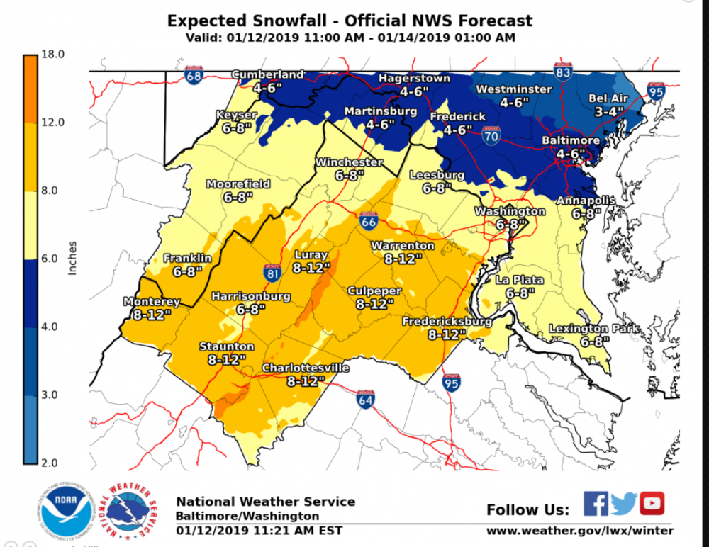
Public Information Statement Spotter Reports National Weather Service Baltimore MD/Washington DC 446 AM EST Sun Jan 13 2019 The following are unofficial observations taken during the past 3 hours for the storm that has been affecting our region. Appreciation is extended to cooperative and CoCoRaHS observers, Skywarn spotters and media for these reports. This summary also is available on our home page at weather.gov/baltimore ********************STORM TOTAL SNOWFALL******************** LOCATION STORM TOTAL TIME/DATE COMMENTS SNOWFALL OF /INCHES/ MEASUREMENT MARYLAND ...Anne Arundel County... Upper Marlboro 4 E 3.2 152 AM 1/13 Trained Spotter ...Baltimore County... Glyndon 1 SW 2.5 151 AM 1/13 Trained Spotter Long Green 2 NW 2.0 200 AM 1/13 Trained Spotter ...Carroll County... Westminster 2 SE 4.0 400 AM 1/13 Trained Spotter Oakland NE 3.5 345 AM 1/13 Trained Spotter ...Frederick County... Bloomfield 2 WSW 4.0 200 AM 1/13 NWS Employee ...Harford County... Bel Air 3.3 321 AM 1/13 Local Official ...Howard County... Simpsonville 1 SSE 4.7 415 AM 1/13 Trained Spotter ...Prince Georges County... University Park 1 E 4.0 339 AM 1/13 NWS Office ...St. Marys County... California 3 W 4.0 352 AM 1/13 Trained Spotter VIRGINIA ...City of Manassas Park... Manassas Park 1 SW 2.6 200 AM 1/13 Trained Spotter ...Fairfax County... Chantilly 2 N 5.3 432 AM 1/13 Trained Spotter Newington 4.3 351 AM 1/13 NWS Employee Chantilly 2 ESE 3.1 150 AM 1/13 NWS Employee ...Fauquier County... Greenwich 1 W 3.5 400 AM 1/13 Other Federal ...Loudoun County... Dulles International 5.1 444 AM 1/13 Airport ...Nelson County... Elma 2 SW 3.0 300 AM 1/13 Trained Spotter ...Prince William County... Dale City 2 NNW 3.5 330 AM 1/13 County Emrg Mgmt WEST VIRGINIA ...Mineral County... Keyser 5.4 325 AM 1/13 Trained Spotter -
Over 5” north of Sterling
-
Considering this storm had 2-4” written all over it a couple days ago. This is a huge win.
-
 1
1
-
-
Nice moderate snow under yellow returns north of Sterling. 27 degrees.
-
Someone needs to ban that dude. It’s sad.
-
1
-
-
At about 3 inches couple miles north of Sterling. Great storm so far.
-
3
-
-
Flurries have begun. 2 miles north of Sterling. 33 degrees.
-
1
-
-
Updated LWX snowfall total map
-
10
-
-
Most Weenie NAM run ever.
-
2
-
 1
1
-
-
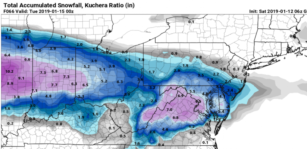
NAM really starts cranking tomorrow. 1 inch per hour rates in DC proper at 16z tomorrow.
-
06z FV3 GFS looks great. Looks like NWS made a good call extending the WSW north.
-
2
-
-
Nice early morning trends for sure from the 06z suite.
-
06Z 12km NAM was a nice improvement from 00Z.
-
1
-
-
anyone got qpf map?
-
Looks like it shifted like a hundred miles north at least.
-
Huge flakes in this nice band here in Sterling. Big dendrites.
-
Back to all snow now under heavier returns.
-
Lot of pingers now. Mix of snow/sleet
-
Heavy fat flakes still coming down. Got over an inch on the grass. Nice event!
-
Really pouring snow again. Huge flakes. 31 degrees.
-
Streets are white. Side roads caved.
-
Big fat flakes. 33 degrees.
-


January 12-13th Cold Smoke Obs and Nowcast
in Mid Atlantic
Posted
Definitely been getting lucky with banding here.