

dsaur
-
Posts
3,734 -
Joined
-
Last visited
Content Type
Profiles
Blogs
Forums
American Weather
Media Demo
Store
Gallery
Posts posted by dsaur
-
-
On 4/29/2025 at 10:05 PM, Shack said:
I remember the 1987 event. (if you can call it that)
Tony, I was working at the Experiment Station in Griffin. (Agronomy Department)
I have always held that moment in my memory of walking outside of the lab and seeing flurries and thinking, "Dang. April???"
Griffin often gets stuff the airport doesn't, Shack
") Of course the airport often doesn't know what's happening all round it, lol. Hope all is well with you!!
Of course the airport often doesn't know what's happening all round it, lol. Hope all is well with you!!
-
 1
1
-
-
8 hours ago, GaWx said:
Tony,
-After a cold winter, March was mild and all but one day Mar 24th through April 4th had 80s! The consistent BN chill didn’t restart til 4/17. From then through August, most dailies were BN! Mid May had a 3 day period with lows in the 40s.
-1909-10 was the middle of a 3 year long La Niña. After that 3 year period came 1911-12, a moderate El Niño with several significant wintry precip events and a cold JF.
-Sunspots: 1909-10 was coming off the 1906-7 peak of the prior cycle, which was one of the two weakest cycles since after the early 1800s Dalton Minimum. The next cycle that was about as weak wasn’t until the one with the very weak min in 2008-9!
-Other Atlanta April measurable snows were 0.6” (4/4-5/1891), 0.2” (4/11/1918), and 1987 (4/3)(measurable northside but only T at KATL).
A below normal summer...wow...must have seemed like a dream, lol. I'm always amazed at the stats you can find. Many thanks for the education! And I like the reference to the minimum. I always think sun spots when a strange cold episode occurs, or volcanoes
-
 3
3
-
-
On 4/26/2025 at 2:04 PM, GaWx said:
T,
- DJF was cold at 3 BN. But M was way warmer than normal! A was near normal.
- Only 0.3” of other SN fell that winter.
- The 1.5” of 4/1910 was the snowiest month since 1/1908 and wasn’t exceeded til 1/1912!
That's surprising as it was so much colder back then, and some of the biggest events were in that period, earlier, but withing 20 years, or so. How many cold snaps occurred that spring? Or was it a true outlier? It just seems so late in the spring to be a one off. But then we had a day or two in the 70's in July or Aug a few year back, and don't remember ever seeing that before. A true one off. I remember after TD Alberto dropped all that rain, the rest of the summer was comparatively mild, but not in the 70's mild. I guess climo works in mysterious ways, lol.
-
 1
1
-
-
On 4/24/2025 at 5:00 PM, GaWx said:
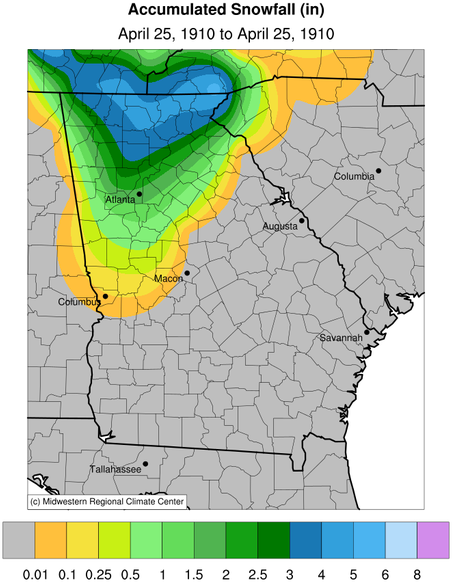
Looking back 115 years ago tomorrow, 4/25/1910, Atlanta had an absolutely amazing event: 1.5” of snow!!! The high on 4/25/1910 was only 39! After March 26th (going back to 1879), they have had highs below 40 only three times: 39 on 4/3/1987, 36 on 4/5/1891, and 39 on 4/25/1910. So, the 4/25/1910 very cold high really stands out in the record books for how late it is.
This accumulating snow so late in April could easily be a once in several hundred year event and could even be a once in a thousand year event.
The old Atlanta newspapers that I read (on microfiche at the public library) and copied forecasted rain and warmer temperatures on April 25th, not snow and colder. April 24th was 18 BN (high of 56 and low of 38) and they thought that that was to be the coldest day of the cold snap. So, this was a big surprise even to the meteorologists!Edit: It appears that even down at @dsaur’s location there was nearly 1”!!
Was that a particularly cold winter? Any other frozen events? What were the sun spots doing? How do we get a repeat, lol.
-
1
-
-
On 4/13/2025 at 12:16 AM, dsaur said:
My new station says I had a 37, so not bad for winters last gasp. The point forecast put the next shot at a 42 low, and I don't count it if it ain't in the 30's, lol. Bye winter..had two slight snows and a slighter sleet, so not too shabby compared to the last bunch of winters, but still pretty pitiful. I'd like to see Rory get his slam, though all three in tandem is what a real slam is, but it's hard enough to get all three in a lifetime
Well, beat the 37 with a 34 , so climo wins again. Hardly ever fails that the weekend of the Master's is cold, or coldish at least one night.
-
1
-
-
On 4/11/2025 at 8:41 PM, dsaur said:
Had a tornado touch down a mile down the road Mon and just found out about it today. I sleep real good, lol. Sounds like it was an f0 or f1, but I haven't gone down to look. Certainly not like the one that went thru a few years ago. That was so loud no one around here could hear the siren a quarter mile away in daytime, and that would have woke me up for sure. It went by a mile south, and I lost trees. This one was a mile west, and apparently blocked roads with downed trees but not here. I didn't hear a thing. Still way to close. I'm ready for winter! Looks like a cool to coldish night for Masters weekend. Right on schedule, but not freezing here. Point forecast calling for 39. Still not bad for what's usually winters last gasp around here. Goofy says there is another chance at coldish, but it's usually over this weekend.
My new station says I had a 37, so not bad for winters last gasp. The point forecast put the next shot at a 42 low, and I don't count it if it ain't in the 30's, lol. Bye winter..had two slight snows and a slighter sleet, so not too shabby compared to the last bunch of winters, but still pretty pitiful. I'd like to see Rory get his slam, though all three in tandem is what a real slam is, but it's hard enough to get all three in a lifetime
-
1
-
-
Had a tornado touch down a mile down the road Mon and just found out about it today. I sleep real good, lol. Sounds like it was an f0 or f1, but I haven't gone down to look. Certainly not like the one that went thru a few years ago. That was so loud no one around here could hear the siren a quarter mile away in daytime, and that would have woke me up for sure. It went by a mile south, and I lost trees. This one was a mile west, and apparently blocked roads with downed trees but not here. I didn't hear a thing. Still way to close. I'm ready for winter! Looks like a cool to coldish night for Masters weekend. Right on schedule, but not freezing here. Point forecast calling for 39. Still not bad for what's usually winters last gasp around here. Goofy says there is another chance at coldish, but it's usually over this weekend.
-
2
-
-
4 hours ago, GaWx said:
Good news, Tony. Since early yesterday FFC pulled back on the prior forecasted high of near 90 at ATL for tomorrow to the upper 80s, similar to RDU. Both cities’ highs are now forecasted to be in the upper 80s for tomorrow and Saturday.
My point cast has always been in the upper 80's, 88 being the highest. Now it's 86, and the difference between 88, or 90, and 86, is vast when you are out in it, in full sun. Not near so apocalyptic this early in the year.
-
1
-
-
2 hours ago, GaWx said:
Per FFC for Atlanta for April 4th:
FRIDAY
MOSTLY SUNNY. HIGHS AROUND 90.If this verifies at KATL, it would be the earliest in the season 90 on record by a whopping 19 days!
Yeah, this just ain't right!! Below normal cold is ok, but record heat...no, just no, lol. And if only one verifies, you know which one that will be....
-
2
-
1
-
 2
2
-
-
2 hours ago, GaWx said:
I’d admittedly enjoy a nice cooldown that week, especially since it would be following a four week long mild period. Also, I’m a chilly wx fan in general. Even if folks don’t want it, I feel it’s important to discuss the potential and not be caught off-guard.
I just enjoy the anomaly factor. Unusual is interesting, and unusual cold even more so. I can see flurries in the wind in Ga during the Masters. Wouldn't be the first time. I'm starting into a book on the Little Ice Age, the minimum...this won't be that, but it's a small taste, lol.
-
3
-
-
28 minutes ago, GaWx said:
Even though it is also on the 6Z Goofy, I realize that with this being out 9 days that this is so highly unlikely based on climo:

I should think plants might want to wear sweaters in case of incoming frost, lol.
-
1
-
1
-
-
Figures it'd be near 90 the weekend before a cold snap. That's a Ga. spring for you. I bought a kite recently, might be able to do a moon landing with the weather whiplash, lol. Near 90 and tstorms...that means wind.
-
2
-
-
On 3/28/2025 at 3:02 PM, GaWx said:
Is there going to be a chilly snap during the upcoming Masters just as has occurred in some past Masters? Be ready to break out the coats one last time then just in case?
@dsauror others have an opinion?
I like the odds. Seen lots wearing sweaters on Master's weekend, so climo says maybe flurries, lol.
-
1
-
1
-
-
6 hours ago, suzook said:
Yup, same here, missed it unfortunately.
Yeah, it's a shame as it was so clear earlier. I've seen a blood moon on a super clear night and it doesn't get old. At least they aren't as rare as a total solar.
-
2
-
-
The haze detracted from the clarity of the blood moon right up until about 20 minutes before totality, then the clouds fully obscured. How do clouds know right when to thicken, and ruin the whole show?? Kind of like snatching defeat from a "heavy snow" warning, lol.
-
2
-
-
On 3/7/2025 at 11:04 AM, GaWx said:
In this area Mother Nature (flowers, bugs, pollen) is saying we had a cold enough winter. Azaleas are still largely not out yet. That compares to some recent ones when they were out in early Feb! Also, I saw no early bugs. They’ve started coming out only over the last week or so: sand gnats, mosquitoes, wasps, etc. My favorite thing about winter is the lack of bugs to bug me. The pine pollen has been out for 1-2 weeks but that’s normal timing.
I’m already looking forward to next winter just like I do for every winter, my favorite season!
I've been getting ticks on me for weeks, and a few mosquitos on the warmest days, but no wasps etc.
-
1
-
-
On 2/25/2025 at 3:02 PM, GaWx said:
All I’m saying is that the MJO is forecasted by most models to be in either phase 1 or 2 in early Mar, which on average have been cooler than normal (especially the coldest phase on avg, 2):
Those are only averages. So, it could easily end up not BN. The other indices (including EPO) say that a strong cold push or multiday period of BN in the SE US in early Mar will be a challenge though of course not impossible, especially in NC based on model progs. Even if it is BN for a few days then, that’s of course far from meaning a NC snowstorm outside of the mountains is likely.
It is important to realize that although the Euro Weeklies have done pretty well this winter, the Euro ops have had a cold bias overall, especially beyond 5 days. Remember the many Euro Barney outbreaks that ended up being no more than a Dino? That’s despite the actual cold outbreaks we had.
It will be cold enough this week and it will be wet enough this week. All it ever takes is timing....and a long list of unlikely scenarios and happenstances, lol.
-
1
-
-
20 hours ago, GaWx said:
This is a great example of different strokes for different folks. I prefer down here in S GA below normal temperatures every month of the year because warmth and humidity is so dominant for much of the year and is getting worse. Also, the cold down here is fairly tame compared to most other parts of the U.S. Moderate cold is very refreshing to me. Also, I tend to sweat very easily (more than most). I love walking but mainly do it inside on my treadmill when dewpoints are 55+. I’d rather be outside. My favorite temps for walking are 40s to 50s (with dewpoints 40s or lower).
There is no right or wrong answer overall. It is all about preference.
The following 50 second video is somewhat relevant though not completely because it is addressing morally right or wrong vs preference in regard to parenting:
Circumstance changes too. Once I was no longer successful in chasing bikini babes, 75 was warm enough, and now I'm on blood thinner, 25 is low enough. I still enjoy winter extremes as long as I can get propane, and they don't last too long in the teens, or below, but 75 is my tops the rest of the year. The only summer extreme I enjoy is 75 in July/Aug. California would be ok, if the cold nights were cold days at least half the time. The way they have it now would make me irritable year round, lol. 25 to 75 and ip/sn once a month would be great, but I don't think that place exists on this planet. Once every few years an f 0 sleetnado or a cat 1 snowacane would be great.
-
3
-
 1
1
-
-
4 hours ago, GaWx said:
-KATL’s 19 low this morning was its coldest since Jan 22nd’s 14 and is the 3rd coldest of the winter.
-KSAV’s 26 low was its first freeze (21st freeze of the season) and lowest since Jan 26th. It was a hard freeze that lasted 7 hours (2-9AM). KSVN’s (not as far inland) low was 29.
-Even the entire coast of GA/SC/NC had a freeze this morning. Ft Pulaski got down to at least 31.
-Much of N FL got down to freezing incl JAX’s 32. Gainesville got at least down to 33 though the winds may have prevented an official freeze. I won’t know til later.
18.8 here. exp sta had 18.5
-
1
-
-
4 hours ago, eyewall said:


I really want to fly my Mavick but both snows I got didn't cover like your's did. Way to go. I'm jealous of you getting shots like that.
-
1
-
-
3 hours ago, GaWx said:
No, I know:


Can you tell me where to get in line for the big winter storm in the first two weeks of March ?? I feel the calling.... It'll be 32 years since the blizzard. Three and two are 5. There are three bugs pictured above. 5 less three is two...and there have been two snows here this year! Boom!!! Drop the mike.
-
1
-
2
-
-
1 hour ago, HKY_WX said:
Did our ancestors draw up the interstates, county and state maps based on Snow totals and 850mb maps? I wonder sometimes.
I'm pretty sure that 1 20 and I 85 are the first data points entered in every model run.
-
Went to bed with a tornado watch, woke up to a squall line and tornado warning. Went back to sleep and snoozed thru it all. Glad I didn't wake up wrapped around a tree. Hope that's it for tornado season
After the Masters, I'll be ready for fall.
-
2
-
-
On 2/12/2025 at 11:33 AM, GaWx said:
And then another wintry threat follows Barney on 12Z GFS
I thought winter cold was over and no more threats from way back in Jan, lol. I guess real winter didn't listen. I saw a blizzard in mid march and heavy snow in late March, so winter is never over until it says it is. Please don't tell me there is a Winter Storm Barney now, lol. Oh, the humanity!
-
3
-
1
-

Mid to long range discussion- 2025
in Southeastern States
Posted
Larry, I was down here, and mile or two from Shack, but oddly the event doesn't stick in my mind. Maybe I was out of town? Thanks for the warm fuzzies") I do love to write.
I do love to write.
As for the airport, I am aware that a central spot that can keep detailed records is necessary, and back in the old days the airport was not the swirling unreality of jet wash, and aberrant heat. Prop planes probably didn't effect the climate like jets do. And, to be fair, it's pilots that needed the up to date findings minute by minute. My sole access to decent weather reporting at one time was PBS at 7am giving pilots the latest updates on what was happening coming into and leaving the airport. Particularly interesting were reports from planes as to what altitude they were encountering snow, or sleet.
So, yeah, while I wish there were scattered reporting stations that would give a local specific, and not general, look at weather around the largest sprawling settlement in human history, I'm not sure the money would be there to man stations, record readings, correlate findings, and store the records. Oddly most citizens are not concerned about the weather on a micro level anyway, lol, unless it's something that will be more than hot or cold, wet or frozen, placid or dangerous. And even then it's way too general.
A good example was tonight about a quarter to nine when the weather radio and my phone buzzed with an alert for a tornado. Run, hide, seek shelter, flee, flee, cover your head. I was calm, because I realize the hysteria that is what general reporting goes with...and it would be way way too general....and the siren hadn't gone off.... and I pulled up several radar sites and noted the storm in question was going north of me, and probably by a good bit. And that's the rub, with too general reporting. If a big wind blows a shingle off an outhouse roof 100 miles from here, these days it's reported to everyone hysterically. No specificity....is it radar indicated, or on the ground? Where is it, like what town? What roads? None of that. If was just warning, get in the basement, the sky is falling. I stream tv so don't get local weather with the street by street reporting.
An aside about the airport, and it's questionable environment for weather reporting, when I was repainting a sign for Hertz in the 90's, I had to remove the metal sign from a building in the parking lot, and bring it home to work on, and was stunned to discover that is was deeply coated with jet fuel residue, basically diesel fuel, kerosene, naptha. That let me know that the whole airport area is awash in droplets of various unburned fuels from the planes coming and going. And does the reporting of the weather and climo coming from the airport take the nature of the air quality over that space into account? Droplets of diesel fuel, acre after acre of concrete, jet wash...it's all got to affect what happens in the climate over the airport. I just think we could do much better, if it mattered to enough people.