

Joe Clark
-
Posts
34 -
Joined
-
Last visited
Content Type
Profiles
Blogs
Forums
American Weather
Media Demo
Store
Gallery
Posts posted by Joe Clark
-
-
8 minutes ago, BornAgain13 said:
18z GFS has caved to the Euro. Dr. No is back.
Sent from my SM-N981U using Tapatalk
Yes. Seen it a thousand times before.
-
 1
1
-
-
-
Until the Euro gets on board with the Tuesday system I'm skeptical. I've seen plenty of times where the Euro lost a storm and was on its own and then watched as everything else caved...
-
 1
1
-
-
Been trending colder the last couple of runs.... overdone?

-
5 minutes ago, PantherJustin said:
its a start lol ^^^ id say no thread until 12z tomm and with some more improvements jmo
Agreed, don't start a thread yet.... usually when its too early its the kiss of death.
-
2
-
-
NWS RAH is showing some interest in this time period as well.

LONG TERM /SATURDAY THROUGH WEDNESDAY/...
As of 320 AM Thursday...
Temperatures will
depend on the exact location of a frontal zone meandering over the
SE US, with additional CAD conditions very possible. Finally, rain
should be the primary precip type through at least Thursday.
Thereafter, the uncertain arrival of Canadian air into the area will
likely hold off until Friday/Saturday, which would yield increasing
chances for wintry precip as additional moisture overspreads the
area from the SW. Stay tuned.
-
4
-
-
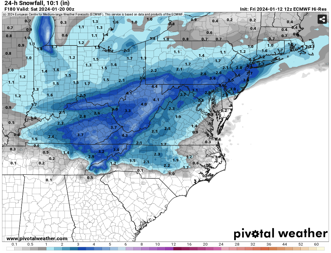
From the Afternoon RAH disco: Long Term: The forecast really gets interesting during the late week period(late Wednesday night through Friday) with high forecast uncertainty wrt to just how much amplification of the cold upper trough will occur over the central and eastern US via additional energy/northern stream energy diving south out of SW Canada. If some of the stronger/deeper H5 height patterns verify, a developing coastal storm tracking along the SE Coast, coupled with the antecedent cP airmass in place, could support the potential for some frozen precip across the climatologically favored areas of the NW Piedmont. Evaluation of the latest 00z/15 Grand Ensemble guidance(100 ensemble members consisting of the CMC, EC, and GEFS members) indicates that ~20 percent of the combined members show measurable snow over the northern Piedmont, with a little over half of those snowy members indicating light snow amounts of 1 inch or less. With that said, these probabilities and related p-type forecast and amounts will without a doubt fluctuate over the next several days. -
-
RAH is showing some interest in the weekend system:
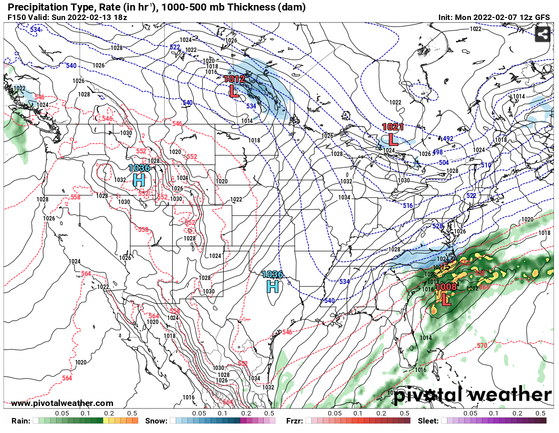
.LONG TERM /WEDNESDAY THROUGH SUNDAY/...As of 220 AM Monday...Expect quiet weather on Wednesday with little synoptic action acrossthe region. An upper trough over the Ohio River Valley Thursdaymorning will dive across the Carolinas Thursday night. While asurface low will eventually develop, this low appears likely todevelop offshore and should have little impact on central NC.However, wraparound moisture could result in a passing showerThursday night. There is still not enough confidence to include popsin the forecast at this time. Behind the deepening surface low, aridge of high pressure will extend down the East Coast on Friday.By Saturday evening the GFS and ECMWF agree that there should beprecipitation over central North Carolina, but from wildly differentsystems. The GFS shows a surface low move southeast from Chicago toWest Virginia before developing a second low off the NC coast, whilethe ECMWF has a low move across Alabama and Georgia which thenstrengthens near the Outer Banks before continuing east. There isdefinitely a chance of precipitation through the weekend andprecipitation type could be an issue, although the temperatureprofiles would look much different depending on which modelverifies. The highest chances for precipitation appear to beSaturday night, although precipitation would likely start during theday on Saturday and linger into Sunday.Temperatures will be below normal through the extended forecast. -
Updated Disco out of RAH:
.NEAR TERM /THIS AFTERNOON THROUGH TONIGHT/...
As of 955 AM Thursday...

...No changes to the current Winter Storm Warning and Winter Weather
Advisories.

Icing has been limited to mostly elevated surfaces, thus far. Most
of the significant icing reports of 0.1 to 0.18 have been from
Forsyth, Guilford, Granville, Vance, and Person Counties (in the
heart of the Winter Storm Warning). The temperatures have been
rather marginal again, with mostly readings in the 30-32 range in
the Warning Area, thus limiting the icing especially on roads. The
temperatures bottomed out around daybreak and have been steady or
slowly been creeping back toward 32 in the Warning area. However,
there continued to be a feed of dry and cold air from northern and
central VA into north-central NC. This is courtesy of the parent
high pressure of nearly 1030 mb located over NY/NJ, extending south
deep into our Piedmont damming region. Low level near surface
trajectories continue to be directed from where temperatures were in
the mid 20s in central VA.

Radar showed showery precipitation with large gaps in the heavier
rates, reducing to drizzle in the gap areas. Thus, it will take a
much of the day for the ice to reach Warning criteria on average
(0.25 or greater) in the heart of the Warning. That will be
challenging given the solar insolation and the temperatures so close
to 32. Some of the heavier showers will contain some thunderstorms
(as there is some instability noted aloft). In addition, some ice
pellets will be mixed with the heavier rain rates in the showers.

It appears that the icing will be a self limiting event in the
Advisory area (Albemarle to Raleigh to near Roanoke Rapids) where
readings should teeter between 32-33 with the CAA at the surface and
the solar insolation / higher rain rates offsetting and limiting
icing to north facing and elevated surfaces.

Models continue to show a lull late morning and much of the
afternoon in the west or northwest, with the steady and heavier
precipitation shifting into the east. Then, another wave aloft will
bring renewed precipitation later this afternoon and evening. Temps
should still be 32 or 31 over portions of the Warning area, thus
additional ice accrual is expected.

The Advisory area is in question unless we can tap into the low
level cold air a bit more in the next few hours

The flash flooding risk appears lower now - given the heavy QPF will
likely be in the south and east (lower end of the main stem rivers),
with lighter QPF of 0.25 to 0.50 over much of the Piedmont.
-
1
-
-
Thunder down in High Point as well. Car thermometer indicated 47F.
-
Sleet near downtown GSO.
-
2
-
-
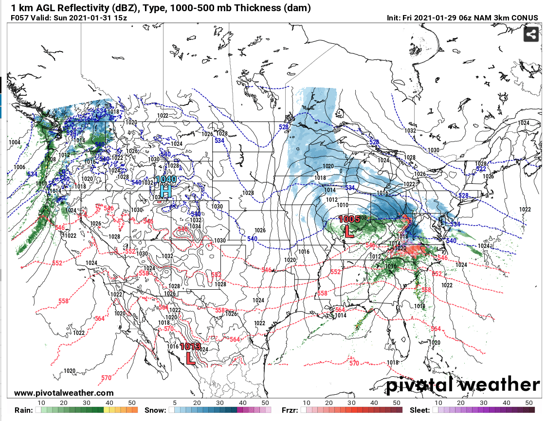
06Z NAM, and the 00z Canadian still showing frozen precip for central NC and points north...

-
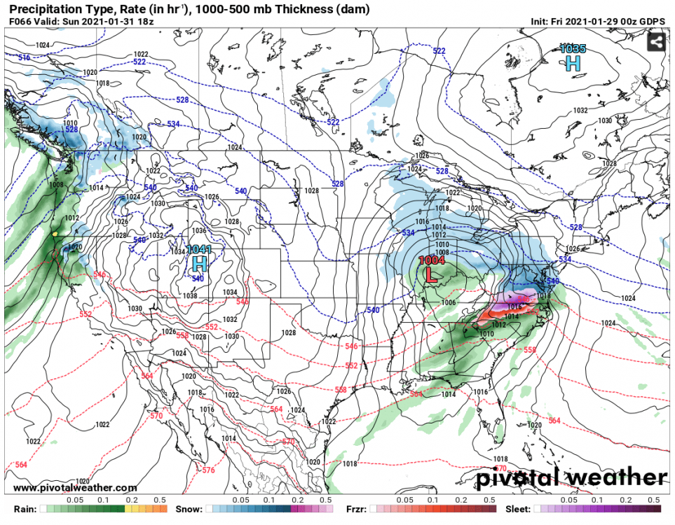
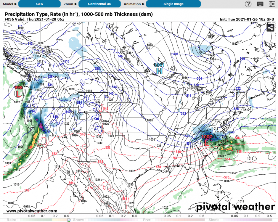
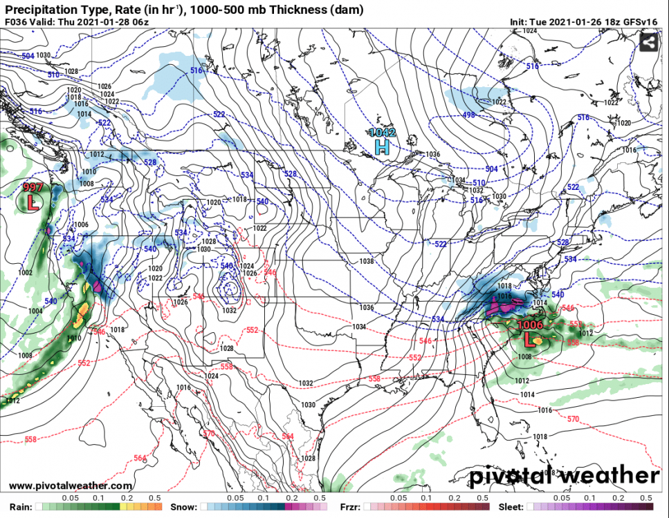
18z GFS and GFS v16 sticking to their guns. Another big hit for central NC Wed into Thurs.
-
1
-
 1
1
-
-
1 hour ago, NorthHillsWx said:
It puts the NAM on its skin or else it gets the GFS/CMC/EURO/UK/RGEM again
I've been lurking this board a long time, and this is some funny stuff right here.
-
19 minutes ago, NorthHillsWx said:
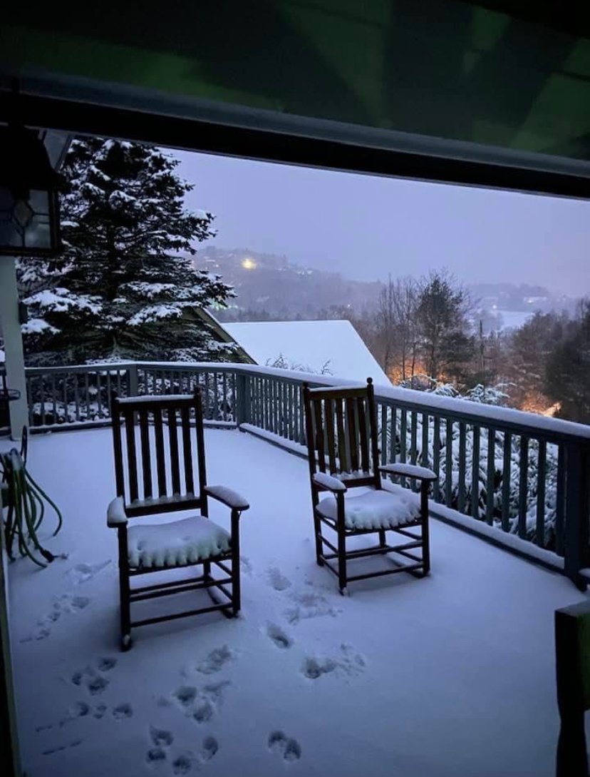
From friend in Blowing Rock early this morning. About 4” in these pics and they’ve picked up a couple more since then. A good spot to be today
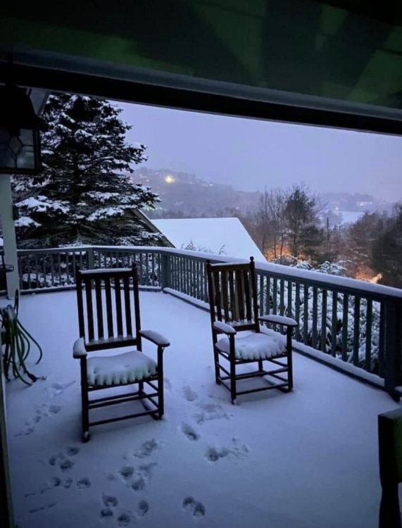
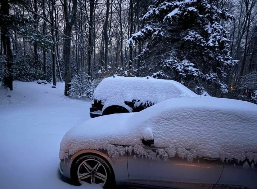
Indeed. The live stream from downtown shows a nice event:
https://www.resortcams.com/webcams/blowing-rock/
-
6 minutes ago, magpiemaniac said:
Colder now than I expected. It’s 24 degrees here north of GSO. I tend to stay a degree or two cooler here than downtown. I’m hoping that pays off for this system.
I'm about a mile west of downtown GSO and I've got 28 this am.
-
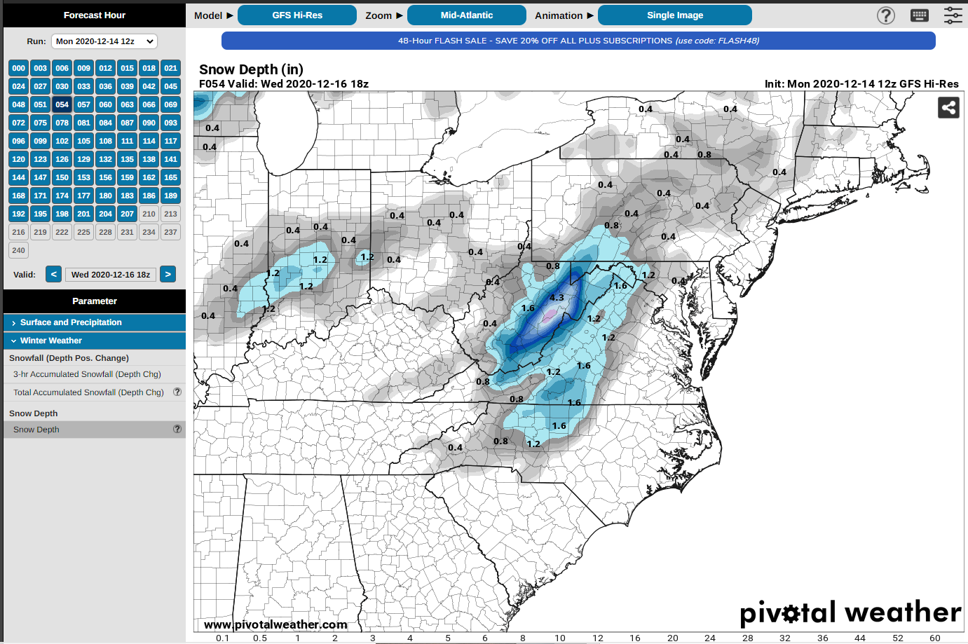
8 minutes ago, BornAgain13 said:
I don't see how we even get an inch of snow here... not sure why the snow depth shows that?? The simulated radar only shows ice then rain here...
I assumed it shows everything frozen as snow....
-
-
RAH Disco from this afternoon:
.LONG TERM /TUESDAY THROUGH SUNDAY/...
As of 330 PM Sunday...

The chance for wintry weather across the N and W Piedmont Tue night
into Wed is increasing. Chilly temps will persist through next
weekend.

Weak ridging aloft will create dry weather across the region on
Tuesday. Cold surface high pressure building into southern Quebec
will send chilly weather into the area throughout the day, with
highs only reaching the mid to upper 40s during the afternoon.

Latest models are coming in better agreement for the Miller Type B
storm for Tue night/Wednesday. An upper-level trough over the mid-
Mississippi Valley will become negatively-tilted and swing across
the area Wednesday. Additionally, a surface low will develop to our
south and move across the coast on Wednesday, and deepen as it moves
northeast along the Mid-Atlantic Coast. Cold air will already be in
place at the surface when precipitation begins Tuesday night with
many areas at or just below freezing across the northwest half of
Central NC, however the limiting factor in wintry precipitation will
be the warm layer above the cold air near the surface. The layer
does not cool enough for snowfall for our area, however a few flakes
may be mixed in a times. Sleet and mainly freezing rain will likely
be the issue for the northwest part of central NC. The highest
amount of ice accumulation on Wednesday could range between one
tenth and two tenths, but this could still change over the next few
days. Temperatures will increase into the mid 30s by late morning,
so precipitation in the afternoon should be all rain, then as
precipitation ends Wednesday evening, a few snow flakes may be mixed
in again with temperatures dropping.
-
-
Curious about everyone's take on these Facebook pages I see that seem to only post snow output maps of every model run. Typically they take the one that gives their area the most and then post stuff like "alert mode" and 'heavy snow possible." I've noticed that many of them have recently posted today's 18z run on the NAM for the late week system in carolinas. Do any of the owners of those pages post on these forums, and are any of them at all reliable in your opinion?


Mid to Long Range Discussion ~ 2024
in Southeastern States
Posted
#facts. Its exhausting.....