
Updated Snow Forecast: Feb. 8-9, 2013

Entry posted by Quincy ·
280,280 views
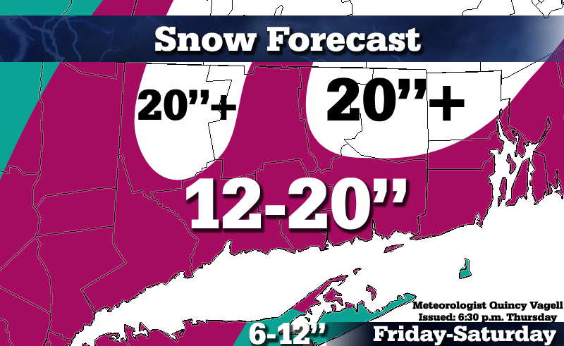 I expect mostly snow for just about all of southern New England (pictured on this map). Although there may be a brief mixture along the I-95 corridor in Conn./RI, I expect crashing temperatures and heights to bring a wind-driven snow right down to the coast and into eastern Long Island.
As far as snowfall totals go, I think that higher ratios will help push NW Conn. and W Mass. to 20"+. Further east, heavy precipitation will offset somewhat lower ratios for 20"+ from IJD to BOS. There is still some uncertainty with areas further south on this map, such as NYC, BDR, GON...lower ratios and possible mixing don't give me enough confidence to go with higher snowfall amounts. With that said, I could see a scenario where even the Conn. coast gets 20". The Euro is basically a 15-25"+ event region-wide and this model has been outstanding with overall consistency in this forecast.
Bands of heavy snow are expected to form and some orographic enhancement may bring this heavy snow right back into the higher terrain of western Conn. and the Berkshires. A snow-shadow effect may limit totals somewhat in the Conn. River Valley, but even there I think totals will come close to 20". Potential exists for 2+ feet, especially across central and eastern Massachusetts.
The other story is the strong winds and power outages are a real concern along and SE of I-95. I think drier snow and somewhat lighter winds inland will limit power issues there.
What really captures my interest here is that expansive moisture field aloft. Past storms, like Feb. 2006, for example, had a relatively narrow area of moisture. This was able to produce intense banding and 20-30" totals from NYC into W Conn. However, with this storm, the moisture field backs into most of NY and covers just about all of New England. The end result is several bands of heavy snow, perhaps even a "mega" band. Snowfall rates of 2-3" per hour will be likely for several hours and convection/isolated thunder is possible.
Winds may gust to 50 MPH along and NW of I-95, with higher gusts to the east. I think we'll see many stations verify official blizzard conditions and Cape Cod/Islands could see hurricane force wind gusts.
0 Comments
Recommended Comments
There are no comments to display.
Create an account or sign in to comment
You need to be a member in order to leave a comment
Create an account
Sign up for a new account in our community. It's easy!
Register a new accountSign in
Already have an account? Sign in here.
Sign In Now