
Snow/Ice Forecast for CT & Vicinity

Entry posted by Quincy ·
4,441 views
 I expect light snow to reach the NY/CT and NY/MA border around 9 a.m. or so and then overspread the area from west to east. The heaviest precipitation amounts impact northern Connecticut into central and western Massachusetts.
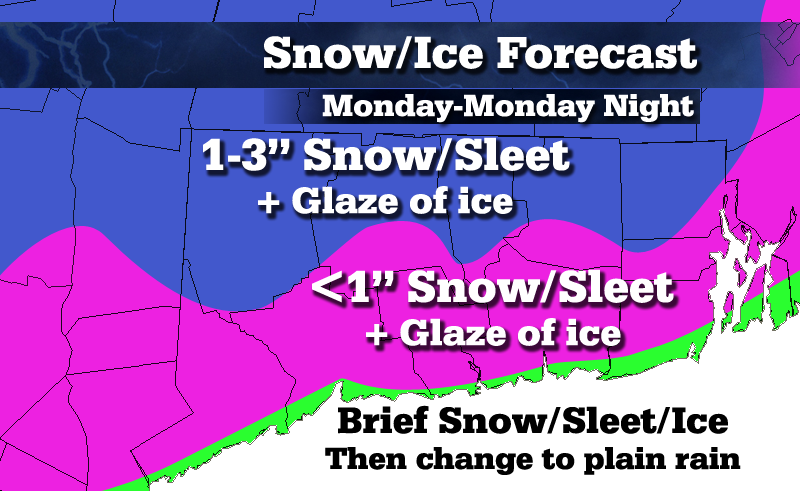
Quick warming at 850mb should push most areas over to sleet and freezing rain. The cold layer aloft up to about 925mb looks deep enough where the inland hills may get a thump of sleet, while the interior coastal plain could see several hours of freezing rain.
By late afternoon precipitation tapers off, but freezing drizzle could linger for many inland areas through much of the night.
Basically expecting 1-3" of snow and sleet, followed by a glaze of ice for inland areas. Best shot at 3" is across the higher terrain of the Berkshires and Worcester County. Keep in mind that this total accounts for snow AND ice. The only area that is a bit of a question mark is the I-95 corridor (approximately). Will have to keep a close eye on surface temperatures and see how cold air damming is verifying. Right now I think that the immediate coast gets a brief period of snow/sleet/ice and then changes to plain rain. Also, somewhat lighter precipitation amounts here may also result in less of an ability for near-surface temperatures to cool. In a marginal setup, heavier precipitation can help result in more freezing/frozen precipitation.
0 Comments
Recommended Comments
There are no comments to display.
Create an account or sign in to comment
You need to be a member in order to leave a comment
Create an account
Sign up for a new account in our community. It's easy!
Register a new accountSign in
Already have an account? Sign in here.
Sign In Now