
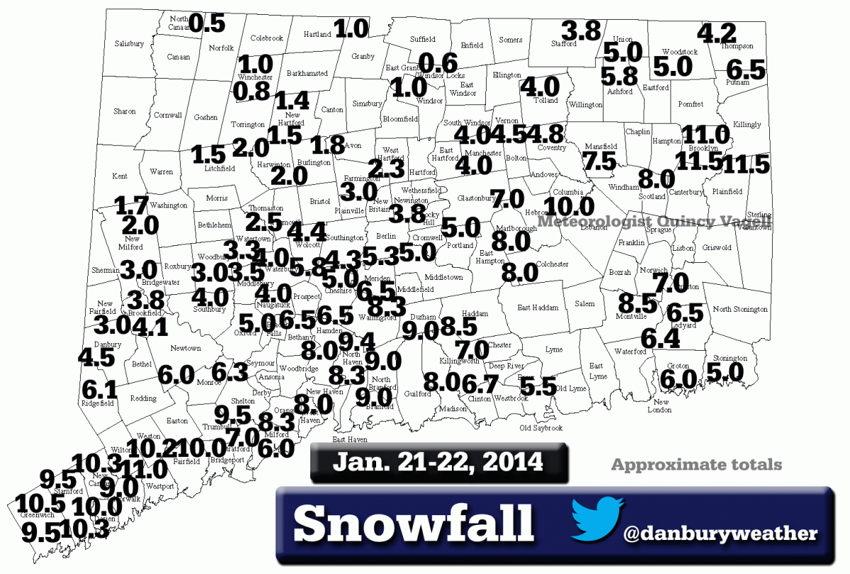
Connecticut Snowfall Totals: Jan. 21-22, 2014

Entry posted by Quincy ·
14,794 views
 Here are some snowfall maps that I created using reports from various sources. Many of the reports came from this forum and the National Weather Service. Only social media reports that passed through quality control were considered.
Flurries began to move into Connecticut shortly after daybreak on January 21st. The snow gradually overspread the state from southwest to northeast and light accumulations were noted across southwestern Connecticut by midday.
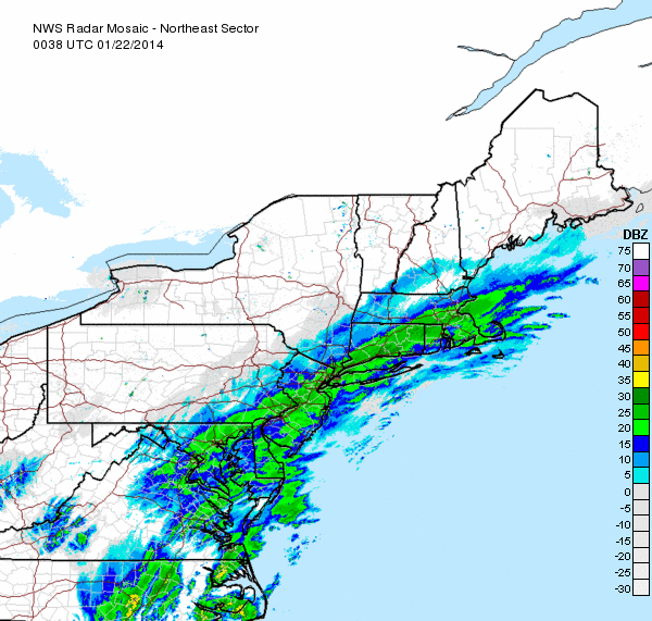
As an area of low pressure developed off the mid-Atlantic coast during the afternoon, a band of heavy snow developed along a SW to NE axis from Philadelphia into Long Island. This band of heavy snow lifted northward and made it about as far as I-84 in Connecticut. Drier air won out on the northwest side of the storm as snowfall totals across Litchfield and Hartford Counties were generally lower than forecast. Areas southeast of the I-95 corridor from Bridgeport to the Rhode Island border also saw less snow, as the heaviest band of snow lifted inland.
The below radar image demonstrates where the heavy band of snow maxed out. Most of the higher-end snowfall totals were observed in the green shading:
With low pressure moving eastward early on January 22nd, snow tapered off from west to east during the pre-dawn hours. By daybreak, the accumulating snow was over and air temperatures had dropped into the single digits above, and in some cases, below zero.
Liquid-to-snow ratios with this storm were fairly impressive. Ratios were commonly in the 20-25:1 range, although some locations observed even greater ratios. Here is a sampling of some of the ratios that were reported:
North Grosvenordale: 30:1, Oakdale: 26:1, Stratford, 26:1, Portland: 20:1, Essex: 19:1, West Hartford: 18:1.
The result was a very light and fluffy snow that was very easy to move and shovel. The fluffy nature of the snow also resulted in settling and compaction.
Here in New Haven, the final snowfall was 8.0". Most of the snow fell before 10 p.m. Snowfall rates averaged around 1" per hour from about 4 p.m. to 7 p.m. when the band of heavy snow moved through the area. The depth of snow as of the afternoon on January 22nd was approximately 6".
Liquid equivalent precipitation amounts were generally less than modeled across Connecticut. Common values were near 0.2 to 0.3", with lower amounts across north-central and northwestern parts of the state. The SREF data did an excellent job at nailing down a region for heavy snow from the northern half of New Jersey into southwestern Connecticut. It was here that the model showed strong frontogenetical forcing and was eluding to a snowfall maxima. With that said, the SREF and many other models were too generous on the northwest side of the storm for precipitation amounts.
Here is a black and white version of the map with filtered reports:
0 Comments
Recommended Comments
There are no comments to display.
Create an account or sign in to comment
You need to be a member in order to leave a comment
Create an account
Sign up for a new account in our community. It's easy!
Register a new accountSign in
Already have an account? Sign in here.
Sign In Now