
Connecticut Snowfall Totals: Jan. 2-3, 2014

Entry posted by Quincy ·
68,590 views
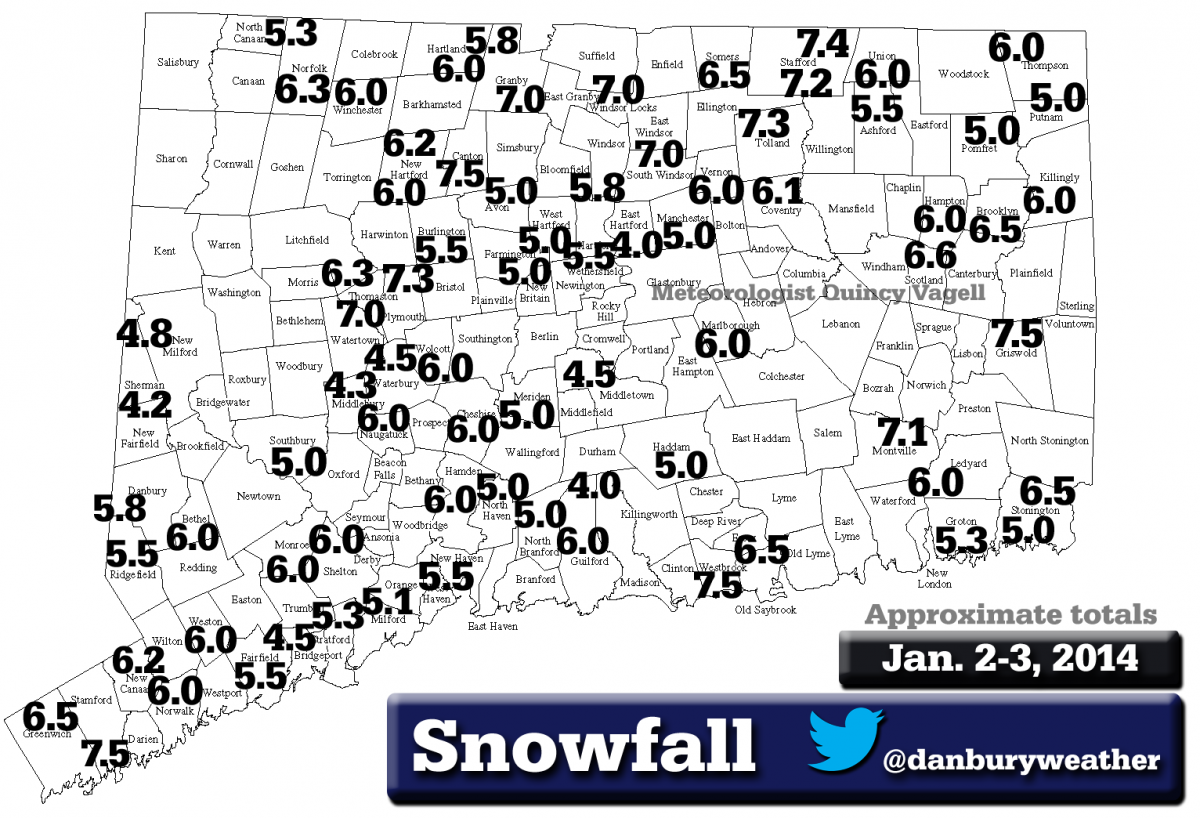
 Here are some snowfall maps that I created using reports from various sources. Many of the reports came from this forum and the National Weather Service. Only social media reports that passed through quality control were considered. Blowing and drifting snow made it difficult to obtain an accurate measurement. Some towns had multiple reports and totals that appeared to be too high based off of surrounding reports were not used.
Some warm-advection snow lifted into Connecticut as early as the night of January 1st, the vast majority of the accumulating snow began on January 2nd. From morning through afternoon, flurries and periods of light snow moved from south to north across the state. By afternoon, some areas, mainly across the northern half of the state, reported an inch or two of snowfall. The 12z sounding from January 2nd at OKX indicated somewhat of a dry layer aloft, while ALY was more saturated. The best snows early on were measured from central New York into portions of interior Massachusetts.
During the evening, low pressure eventually developed off of the mid-Atlantic coast and an area of snow filled in across Connecticut. It was from about 9 p.m. to 4 a.m. that the heaviest snow fell. The bands of heaviest snow wound up remaining south of Connecticut and there were even more impressive snowfall totals across eastern Massachusetts. There, ocean-enhancement was a key role in significantly higher snowfall amounts.
In Connecticut, accumulating snow ended by mid-morning on January 3rd, with most areas receiving anywhere from 4 to 7 inches of snow. There was a narrow band of 7 to 7.5 inches across the northern part of the state, where additional snow during the beginning of the event increased overall totals. Close to the coast, there were also a few totals of 7 to 7.5 inches, where some towns were grazed by heavier snow toward the end of the event.
While there were a few snowfall totals reported in the range of 8 to 9+ inches, those did not line up with other totals in the same or neighboring towns. Strong winds caused blowing and drifting snow, which was the most likely cause for the totals that were assumed to be erroneously high.
One variable that was generally missed by the computer forecast models was lower liquid-to-snow ratios. While these ratios are generally close to 10:1, model forecasts predicted anywhere from 15-20:1 ratios, or even higher. If higher ratios had been observed, snowfall totals across Connecticut would have been higher. In the end, ratios were fairly close to 10:1.
It was quite cold during the storm with temperatures falling into the lower 10s and single digits by the morning of January 3rd. Although there is a loose correlation between surface temperatures and snow ratios (colder yielding higher ratios), it was the snow growth above the surface that did not promote higher ratios. Surface temperatures alone have no impact on snow ratios, unless the temperatures are near or above freezing, then they can actually lower the ratios.
If any amounts you reported conflict with these amounts, please comment back with your total(s).
Here is an alternate black and white version of the map:
0 Comments
Recommended Comments
There are no comments to display.
Create an account or sign in to comment
You need to be a member in order to leave a comment
Create an account
Sign up for a new account in our community. It's easy!
Register a new accountSign in
Already have an account? Sign in here.
Sign In Now