

Santa Claus
-
Posts
8,202 -
Joined
Content Type
Profiles
Blogs
Forums
American Weather
Media Demo
Store
Gallery
Posts posted by Santa Claus
-
-
i love you you insane weenie
-
 1
1
-
-
I'm ready for thunderstorm season boys. Let's kick it off in style, fire up the SE ridge, pop a few 80-balls around the end of the month and get some squall lines in here.
-
 1
1
-
-
3 hours ago, Stormlover74 said:
Killed 2 mosquitoes already today
They got me several times in Helyar Woods on Sunday. Unbelievable.
-
16 minutes ago, matt9503 said:
Fair enough...but you agree that we’re royally screwed financially?
It's definitely a serious pickle. Our monetary and fiscal policy looks too similar to the setup which led to the Japanese Lost Decade, our demographics and economic style both point to low growth. I complained last year to anyone who'd listen that it was abnormal and unhealthy for stock prices to climb like 25% without comparable earnings growth. I think people have forgotten what the stock market actually is, to be honest. At least, the retail investors all have. Or, they never understood it anyway.
-
it wasn't just corona but the Saudis declaring an oil price war is a jet fuel hose on the market fire.
the next few months we are going to see some incredible shit.
-
1
-
-
just give me the ****in virus and let's get it over with
if i make it out of 2020 alive and employed, everything else is gravy. i give my chances of each about 50/50
-
4
-
 2
2
-
-
Ban all weenies.
On 3/2/2020 at 4:51 PM, forkyfork said:how many times will the dewpoint hit 80 next summer?
Yes.
-
1
-
1
-
-
Feels like a spring morning.
-
1
-
-
6 minutes ago, gravitylover said:
Such a stupid game
the world is filled with all kinds of people lol...
-
1
-
-
On 2/19/2020 at 1:05 PM, CarLover014 said:
50 here as well. Feels great outside. The high cirrus clouds, if they stick around for awhile will set up for a pretty sunset this evening
Had a few great sunsets this week and some bigly yuge sun dogs on Wednesday.
-
1
-
-
It is very nice out today. About 50 F, nice warm sun, bit breezy.
-
1
-
-
1 hour ago, Isotherm said:
As delineated hitherto

-
1
-
3
-
-
Just based on the radar and the weather outside I'm thinking the rain forecast is going to bust pretty low.
-
On 1/30/2020 at 11:03 AM, Will - Rutgers said:
It's going to have to snow pretty hard for anything to accumulate. I'm thinking melting flakes at the shore, probably 1-2" N&W.
nobody liked my joke
i'm kinda sad about it
-
1 hour ago, donsutherland1 said:
It's going to have to snow pretty hard for anything to accumulate. I'm thinking melting flakes at the shore, probably 1-2" N&W.
-
7 hours ago, bluewave said:
The January highs and lows were nearly identical to Atlanta so far.
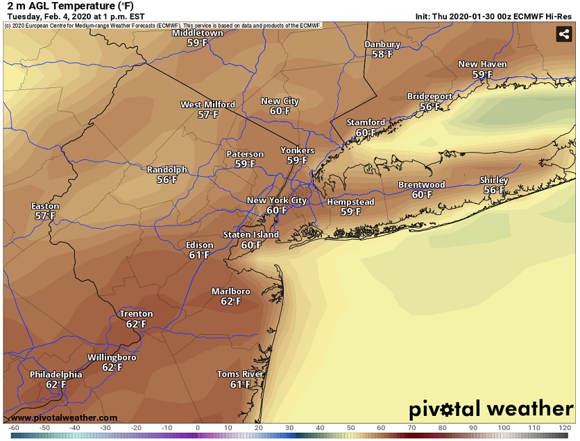
Atlanta.....72....23
NYC..........69....20.......EWR.....70....20Forky nailed it months ago... we're Atlanta with snow.
-
Regardless of impacts to our locale... this is the second massive, impactful, country-spanning system in a week. It's nice to see the shift.
-
3 hours ago, bluewave said:
The ensembles were never particularly great day 11+. It may just be that they are getting posted more with the rise of social media. So they are now coming under greater scrutiny.
Absolutely agree. To borrow an investing phrase, people are "reaching for yield" because the shorter-term forecasts are brutal for snow chances, and we're looking into less-reliable products hoping for hope.
Also since this is the general OBS thread I'd like to OBS that it's brutally cold outside and my body is not ready because I was hiking in shorts last weekend and I have no idea what's going on anymore.
-
1
-
-
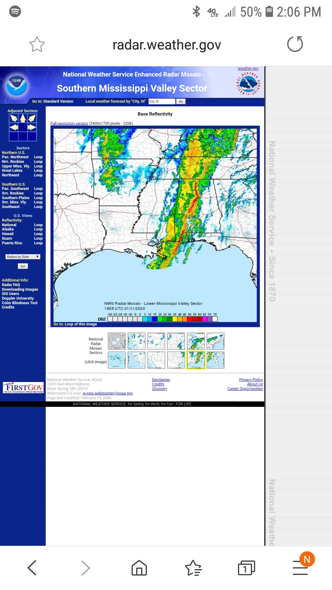
Check out the squall line obliterating the Southeast.

-
52 minutes ago, HVSnowLover said:
At this point my mentality is if it's not going to snow, may as well be warm, I don't mind the mild weather. The worst patterns to me are when it's cold but then storms track to the west and we warm and up and get rain.
Well you're definitely getting some warm(ish) and rain the next two days. We might see some ridging this winter that allows for a warm and dry scenario. I think some model posts showed it in this thread.
-
1 hour ago, SnoSki14 said:
We may see the rare 70F+ temp pop up if that map is correct especially if there's a major cutter.
Probably a bit aggressive but dunno if it's a fully-wienerable prediction, given how often we've seen warmth significantly undermodeled. It's a strong signal to keep an eye on.
-
1
-
-
I'm not really sure what happened with my point-and-click, was expecting a gusty day but there's no wind outside. I guess once this front moves through we'll see that transition. Any chance of PA snow squalls making it through to NJ?
-
Just now, weatherpruf said:
This is sarcasm, right?
 bro come on
-
infrared radiation and the greenhouse effect are MSM hoaxes the left uses to force us to buy that ridiculous tesla cybertruck and i'm SICK OF IT
-
2
-
 1
1
-
Spring 2020 Banter
in New York City Metro
Posted
My friend is a doctor in Brooklyn (whose hospital was featured in The New York Times a few weeks ago due to the early tsunami of patients) who got it. Seems mild fatigue was his only symptom and it subsided in about two days. The diversity of outcomes is fascinating and scary and will make for really interesting research papers that I am sure are already being worked on. Hopefully yours is equally mild, feel better soon.