
lte5000
-
Posts
56 -
Joined
-
Last visited
Content Type
Profiles
Blogs
Forums
American Weather
Media Demo
Store
Gallery
Posts posted by lte5000
-
-
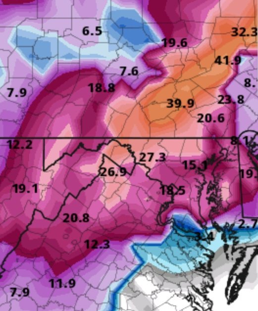
Right around 5" in Myerstown, Lebanon County.
Great storm, models did a good job of nailing it for my backyard.
-
FWIW, some positive thoughts from Eric Horst. He posted this on Tuesday, but I just noticed it this evening:
QuoteRecently, I've been asked if it will ever snow here in a significant way? I believe so, but I don't see anything imminent. What I do see is a playing field (the large-scale pattern) that's now populated with most of the necessary ingredients--they just need to come together in the right way to support a "mostly snow" storm here in Lancaster. With Arctic air making several passes at us in the coming weeks and a continuing parade of storms off the Pacific, I believe it's only a matter of time until things do time out right for a decent snow storm in our area. I certainly will NOT promise a crippling snowfall...but I'll be very surprised if we didn't get a good 6"+ storm (or two) sometime in the next four weeks.
After the upcoming midweek "mostly rain" event, Arctic air will return Friday through Sunday. A clipper system might bring us some weekend snow showers, but it doesn't look very impressive. Milder air will make a brief run at us next Monday or Tuesday ahead of another sharp Arctic blast arriving for the final days of January. While I don't see specific storm to watch for next week, this is the kind of energetic, amplifying pattern that is conducive to coastal cyclogenesis...so it's something to watch as next week nears.
My 35 years of forecasting experience tells me that this is definitely NOT a pattern to snooze over--in fact, in this kind of pattern the "big snow event" is often not apparent 7+ days away...and often only reveals itself inside of 5 days. Therefore, it's kind of a fun pattern if you like conflicting inter-agency forecasts, rumors of storms, and late-forecasted "surprise" snow. Stay tuned! --Horst
-
The zone forecast for Lebanon County was changed from 8-12 down to 6-10... my guess is that's still too high, but I hope I'm wrong.
-
Stolen from the MA forum - New Years Day Storm (GFS FV3):
-
^ Thinking I might have to set my alarm for around 4 am to catch the good rates.
Central PA - Jan/Feb 2019 Obs and Discussion
in Upstate New York/Pennsylvania
Posted