
MillerA
-
Posts
318 -
Joined
-
Last visited
Content Type
Profiles
Blogs
Forums
American Weather
Media Demo
Store
Gallery
Posts posted by MillerA
-
-
Gsp discussion
TERM /THROUGH TONIGHT/...
As of 1045 AM EST: Upper divergence is ramping up, as indicated
by cooling cloud temps streaming into the area thanks to right
entrance region jet dynamics. This forcing is causing more snow
to fall and seed the low-level moisture across the NC mountains
(lots of reports of accumulating snow). So far, all the model
guidance seems to be struggling with this (consensus PoPs are less
than 15%). So it`s really challenging to assess how much this will
continue as we head thru the day. For now, think QPF will be very
light, and will handle with a Special Wx Statement (SPS). But an
advisory may be needed, if banding sets up (or the snow just stays
more persistent than expected). Outside the mountains, there`s
a deeper dry layer preventing the seeder-feeder mechanism at the
moment. However, both the NAM and GFS fcst soundings show overall
moistening profiles this aftn, and frontogenesis will ramp up toward
sunset, as a strong shortwave approaches from the west. The banding
will be parallel to the frontal zone (SW-NE orientation), but
the exact placement is still up for debate among the guidance. It
could very well set up over the southern and central NC mountains,
extending to the NW NC Piedmont. Then, things will shift SE, and the
best rates are still expected to be from Greenwood, SC to Cabarrus,
NC and points E. This is where our current Winter Wx Advisory is,
and that looks good. With the overall trends in the guidance since
the 00z runs trending a little higher QPF this evening further
west into the Piedmont, we may need to expand the advisory. But
there`s still not enough confidence, and will assess all the 12z
guidance and the latest radar/satellite trends before making a
decision. Will handle non-mountain snow/black ice concerns with
an SPS as well for now.
Otherwise, temps/dewpts/sky/wind all look good. It`s just the
PoPs/QPF/SnowAmt we`re really concerned about.
A strong short wave drops into the area tonight along with a
strong upper jet streak. This induces cyclogenesis off the SE
coast. The surface low remains relatively far off shore. The H85
low is also to our east. This keeps the low level flow weak and E to
NE. There is quite a bit of low level moisture across the area but
no significant moisture flux from either the Gulf or Atlantic. There
is an increase in deep moisture late this afternoon and evening
though. Given the strong forcing and decent moisture, have trended
toward the higher precip chances seen in the guidance. That said,
don`t have any likely PoP west of the I-77 corridor. Expect there
will be precip moving west to east across the area, but coverage
and QPF will be limited. Forecast soundings and partial thickness
values suggest mainly snow for most of the area. Some sleet will
be possible at onset, with more of a rain/snow mix over NE GA,
the western Upstate, and the warmer NC valleys to start. Precip
changes to all snow before ending after midnight.
Highs today and lows tonight will be well below normal.
-
 1
1
-
-
22 and almost 5 in Newton.
-
 2
2
-
-
I am now down to 1 to 2 inches, lol.
Newton, nc
-
3
-
-
Here is Futurecast from NBC
-
1
-
-
2 minutes ago, MillerA said:
Gsp noaa weather office has out their afternoon discussion, and have updated local forecast. Enjoy.
LONG TERM /SATURDAY NIGHT THROUGH WEDNESDAY/...
As of 240 pm EST Wednesday: The forecast for the weekend remains in
a state of flux. Readers are advised to continue to manage their
expectations. On the one hand, confidence continues to increase
that we will have a winter storm that will probably impact the
entire forecast area beginning Saturday night and continuing
through most of Sunday. Precip probs are now into the categorical
for that time period. On the other hand, details about precip-type
distribution are very murky in both space and time, and that is
having a negative impact on confidence. The latest problem is
the operational GFS solution, which has trended toward moving the
850 mb low well west of the mtn chain, allowing for strong warm
advection that would establish a warm nose in most places east
of the mtns. The result would be a steady changeover/mix to sleet
and freezing rain, if the operational GFS is correct. It is worth
noting the 12Z GEFS is still holding onto snow as the most likely
p-type at GSP, but there is enough of an increase in sleet/freezing
rain outcomes that places like CLT have an almost equal chance of
the primary p-type being any one of the four. Meanwhile, the ECMWF
keeps its 850mb low moving overhead/southeast of the mtn chain. The
operational ECMWF would allow for a long enough period of time for
snow to fall east of the mtns before a weaker warm nose pokes up
from the south to changeover along/S of I-85. Worth considering is
that in most situations, the warm nose wins across the area south of
I-85. Still way too early to consider amounts of individual p-types,
but the trend in the QPF has gone up substantially, which will
in turn flow down into the precip accums. The forecast guidance
blend used to create the new fcst will sometimes show a lag that
does not quickly jump to any new trend, so for the time being,
the fcst will look more like the cooler ECMWF/Canadian ensembles
instead of the more icy GFS. High temps will not get out of the
mid-30s. Eventually, as the system passes, a change back toward
light snow should happen late Sunday. Model guidance shows a strong
signal toward a NW Flow Snow event along the TN border Sunday night
that would continue through Monday and might not taper off until
Tuesday morning. Temps will remain about 10 degrees below normal
through Tuesday, with a warming trend into Wednesday. Another
weaker system may approach from the west Wednesday afternoon,
but this was downplayed for the time being. -
Gsp noaa weather office has out their afternoon discussion, and have updated local forecast. Enjoy.
-
1
-
-
Same here in newton. Not doing anything at all. A dusting at best.
-
Gsp short term. Not putting catawba and iredell into the warnings yet.
As of 1015 am: Water vapor imagery shows upper low centered near
Ark-La-Miss junction. Associated cirrus shield will continue
spilling over the downstream ridge into the forecast area throughout
the afternoon, resulting in generally mostly cloudy/partly sunny
conditions. Filtered insolation will likely result in max temps
around 5 degrees below normal across much of the area this
afternoon.
Model consensus carries the surface low south of the I-20 corridor
late today through Friday morning, with the core of the upper
low moving near the southern border of TN and NC during this
time frame. This will place most of the CWA just on the cool side
of the warm front. Most of the area will start off well above
freezing in the early evening; moisture will quickly deepen as
the sfc/upper low encroach on the area before midnight, bringing in
precip chances from the SW. The strongest dynamic forcing will
precede the upper low into the area, peaking in the predawn hours
Friday, with the better moisture lagging the forcing somewhat. The
best frontogenetic forcing will occur nearer the warm front. Precip
type still looks quite tricky, mainly east of the mtns, and perhaps
across the mountain valleys of southwest NC. There will be a lot of
midlevel dry air to overcome early in the event, and the WAA gives
us a weak warm nose as well (though not as strong as we often see
with these sorts of systems). The higher mountains likely will see
snow through most of the event, but lower elevations and areas
further south will see some period of sleet, or perhaps even
freezing rain where the warm nose (along with evaporative cooling
diminishing it at least locally) is present. Confidence is
sufficient such that all zones in the Watch were converted to a
Warning earlier this morning with the exception of Catawba, Iredell,
and Davie Counties in NC. This area will take longer to see
accumulation reach any criteria, and with the potential for
accumulations to go one way or the other, we have held off on
upgrading there. These areas almost certainly will need an Advisory
or Warning depending on where their final forecast total ends up.
With the upper low crossing the area during the day Friday, even as
winds turn more downslope and moisture becomes more shallow, there
will remain support for significant precip as the deformation zone
scrapes the NC Piedmont. Temperatures will be held nearly steady in
the 30s where the precip is ongoing, and many areas will continue to
see snow during the day, possibly mixing with rain. Strong lapse
rates under the low may allow enhanced precip rates and snow will be
more likely during those periods. The event will transition to
northwest flow late Friday across the NC/TN border area as PoPs
continue to drop off east of there. -
38 and a light rain is moving in. Newton, NC. Rain cooled us down 2 degrees.
-
4 minutes ago, wncsnow said:
SREF went down a lot for HKY and AVL
How much did it go down for both?
-
-
-
Charlotte spectrum news futurecast at 1pm tomorrow.
-
 2
2
-
-
-
Check out @NWSGSP’s Tweet:
-
Just now, NCSNOW said:
RGEM through 72 keeps 850 below freezing whole time for triad. For what uts worrh
Over to hickory as well?
-
Check out @RaleighWx’s Tweet:
Check out @RaleighWx’s Tweet:
-
-
2
-
-
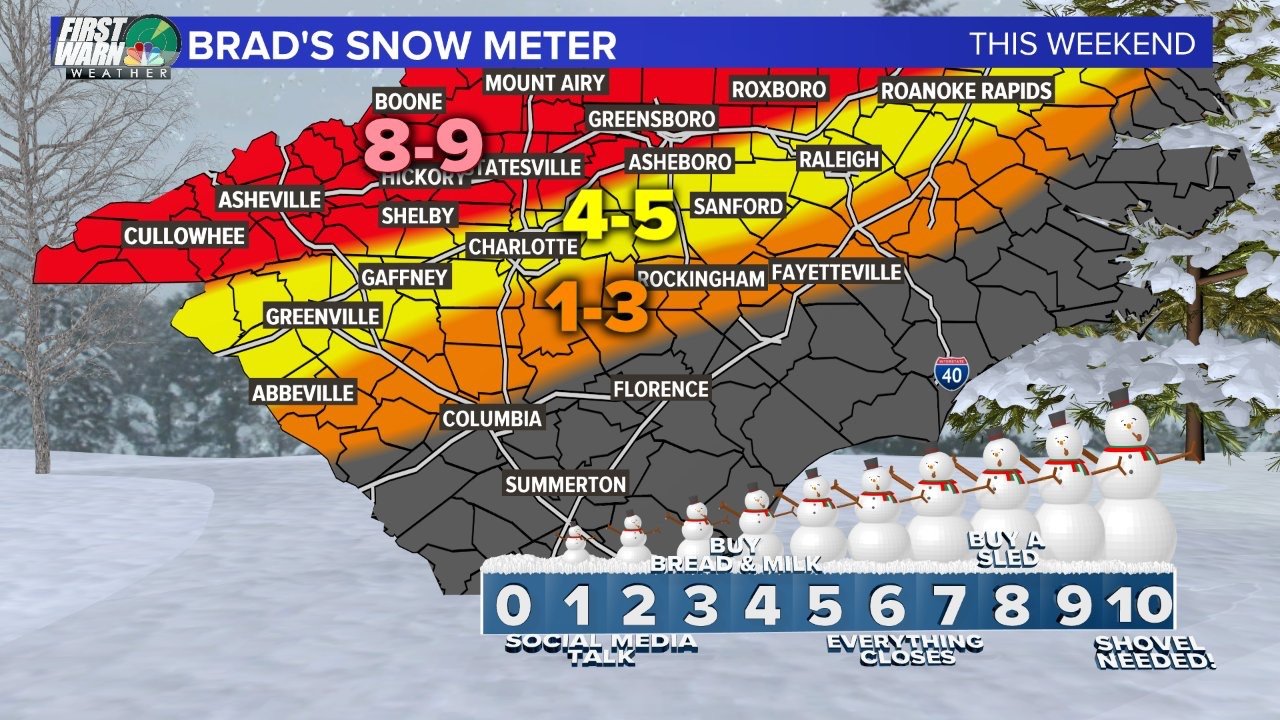
2 minutes ago, Regan said:
Wow. Not as conservative as I was expecting. Brad Ps 1st call map.
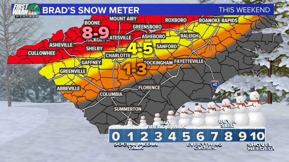
That is his snow meter map not his accumulations forecast.
-
Check out @RaleighWx’s Tweet:
Check out @RaleighWx’s Tweet: https://twitter.com/RaleighWx/status/1070024504171212800?s=09
-
2
-
-
15 minutes ago, Wow said:
Looks about right given the track as far as the r/s line is concerned.
Is this a fri night/Saturday storm or Saturday/Sunday storm?
-
Me and my 5 yr old, Sara.


Potential 1/28-1/30 2022 winter storm
in Southeastern States
Posted
GSP Disco - Ouch for the piedmont..They appear not thrilled about advisory level snow.
SHORT TERM /6 AM FRIDAY MORNING THROUGH SATURDAY/...
As of 230 PM EST Thursday: Guidance continues to indicate that
a midlevel trough will sharpen over the Tennessee Valley Friday
evening, even as a 120kt upper jet shifts over the Carolinas,
amplifying into a split stream pattern aloft. This allows upper
divergence to blossom off the NC coast overnight, and paired
with deep-layer DPVA streaming into the Carolinas, this will
result in rapid, potent cyclogenesis off the central Georgia
coast. Both deterministic and ensemble guidance continues to
favor the eastward, just-offshore track for the developing
surface low, which suppresses a robust warm conveyor belt across
the NC/SC Piedmont and inhibits development of a warm nose
aloft, allowing for a rare rain-snow-only forecast for the NC
Piedmont and SC Upstate.

From perhaps 00Z Saturday onward, strengthening NW flow across the
mountains will result in a widespread rain-snow mix beginning Friday
evening, transitioning to all-snow by midnight.  Lee troughing
east of the mountains appear to result in the development of an
additional circulation over the Piedmont, depicted in the HREF as a
small-scale low pressure system which skirts just north of the NC-SC
border.  As a result, a changeover from rain to snow is expected
across the NC Piedmont and at least the northernmost part of the SC
Upstate, before profiles dry out leading up to daybreak Saturday.
So, at this point, the NC Foothills/Piedmont and SC Upstate are
forecast to see small accumulations, below advisory criteria; the
NC mountains will see more appreciable snowfall.  A Winter Weather
Advisory has been issued for Buncombe and northern Jackson Counties,
while an elevation-dependent Winter Weather Warning-Advisory has
been issued for counties along the NC-TN border.

After daybreak Saturday, the rapid intrusion of dry cP air on the
backside of the departing system will sap profiles of their ability
to produce precipitation, even as Z500 heights rebound.  Gusty winds
embedded in post frontal CAA are likely across the mountains
and, more sporadically, the NC/SC Piedmont. Clear, dry
conditions will maximize radiative cooling Saturday night,
allowing temps to drop into the mid- to low-teens across most of
the forecast area.