

jlauderdal
-
Posts
214 -
Joined
-
Last visited
Content Type
Profiles
Blogs
Forums
American Weather
Media Demo
Store
Gallery
Posts posted by jlauderdal
-
-
45 minutes ago, SchaumburgStormer said:
Fuck that, its cold.
But it does appear to be some white rain.
I live in Sofla, was up there last weekend(a week too early but i did get the pre-xmas ground blizzard last year, missed the fort laud tornado last weekend) and its was raw the whole time but the snow looked good albeit very modest totals. Congrats on this sytem and avoid dry slots the rest of the season.
-
Go outsideI have some sort of precip falling, but through the window I cannot tell if it is rain or sleet.-
 3
3
-
-
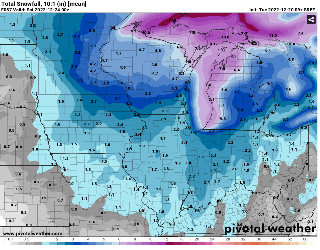
GFS vs Euro with very different solutions, we see it consistently in the tropics, especially with deep systems. Congrats on the wintry pattern, I was there for 3 days, left yeaterday, snow on the trees was scenic.Sooo Euro has a 12"+ bomber and GFS says maybe 6"? -
Thoughts and prayers from a floridian, the recovery efforts wiil take time from the light rain and breezy conditions.SOE. You are urged to stay indoors. Be safe and be prepared to evacuate.-
1
-
-
Its like the hurricane cone of confusion on accu weather, all interests from Brownsville to Nova Scotia are in play.Broyles cant be wrong if he broad brushes the entire country-
1
-
-
That storm delivered even with traveler advisory totals in chicago. Back to blustry south florida,wont even hit 60 this weekend. Good luck the rest of the winter with big totals.It's official. High of -1 at ORD on Friday, making it the first December day to stay below 0 since Christmas 1983. Impressive stuff. -
Barely travelers advisory criteria.1.1" ORD, and likely the final total. -
1 minute ago, sbnwx85 said:
Indiana Department of Homeland Security is deploying military personnel to help drivers who get stuck on the Indiana Toll Road starting tonight.
close the road if its that dangerous
-
 1
1
-
 1
1
-
-
Flurries in Naperville, no wind
-
Too bad the gulf never fully opened for business.Officially in the phase where I hope the storm just goes AWOL and deliberately spites all guidance and blasts N IL with a meter of snow.-
1
-
-
1-4, snow and blowing snow18z Euro actually a tick east after Hour 60 as the low crosses northwestern Ohio; leads to a small shaving of northern IL QPF. -
Good shot of verifying with those ranges.Just a bit of range here MKX...
-
We dont need much to it get back to ne illinois. Baby steps and a slight trajectory change upstream and you have something. Model bleed has slowed for now.This is a fair forecast -
Post of the day, you beat me to it..to understand what is happening, you must look beyond your CWAbecause it affects the endgame for this system up here. weather is not your backyard only.-
1
-
-
When its all said and done, todays sofla event might be bigger than the midwest event. There is a low moving across the gulf, giving us rain and choking the moisture feed for the midwest system.
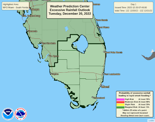
NWS Miami @NWSMiami
@NWSWPC has placed all of South Florida in a Marginal Risk (1 of 4) of excessive rainfall. This means that isolated flash flooding is possible, especially in vulnerable urban locations.
-
34 minutes ago, hardypalmguy said:
wow, what a disaster to wake up to this morning. another storm crapped the bed. at least I'm leaving for Tampa in a few days. palm tree weather coming.
not really palm tree weather in florida this weekend but better than windchills
-
1
-
-
1 minute ago, King James said:
Brutal AFDs from wx offices yesterday if this one ends up crapping the bed.
They working with mostly the same data we are, it is what it is and they have to take stand at some point and they did.
-
This won't be needed, at least for me.

Important Information regarding your upcoming flight Severe winter weather conditions across the Midwest may cause disruptions to our operation, including flight delays or cancellations. As of now, there are no changes to your itinerary. We will notify you if this occurs. We are happy to offer customers with flexible travel plans the opportunity to fly on a different day or connect in a different city at no additional cost. To review options, visit the My Trips section on the United app or united.com. If your travel has been booked with one of our airline partners, we recommend reviewing their travel guidelines to determine options.
-
Just now, SchaumburgStormer said:
Well that was fun. Multi-season final 48hr trend will not be denied.
I will take my 2-4 and enjoy the white Chris over the usual warm and brown turd sandwich we are typically served.
2 is far more likely than 4 at this point
-
8 minutes ago, magoos0728 said:
They'll keep it in place simply for "holiday travel"
Yeah...that's the ticket!
This afternoon if this trend continues, there shouldn't be a wsw just because of holiday travel....i could make case there are more people travelling around northern illinois on a normal workday then during the holiday when people are sitting at home on their arse hitting refresh on this board..

-
1
-
-
8 minutes ago, A-L-E-K said:


The WSW for northern illinois is in jeopardy to be honest. Good Luck the rest of the season, my trip to to chgo appears to be with limited fanfare and thats ok...hurricane season is right around the corner, lol. The trend is definitely not Northern Illinois' friend. BTW, this is why the hurricane center never deviates from their watch/warning criteria regardless of holidays or other subjective criteria, its all science and zero deviation ever. They do have a "Potential Tropical Cyclone" package at their disposal for situations where it hasn't developed but has shot at hitting land. Potential Winter Storm would have been good for LOT yesterday. A high wind event isnt a Winter Storm and that's where this heading.
-
3
-
-
1-4 with blowing snow for the LOT service area, happy holidays from santa claus
-
For what it's worth, WPC's discussion on model guidance, updated today at 4pm Central....Guidance/Predictability Assessment...
The latest guidance continues to show much better agreement on the expected synoptic scale set-up for the major Eastern U.S. low pressure system. The 00z and 06z runs of the GFS continued to show a slower and slightly farther south track with the main upper low compared to the ECMWF, CMC, and UKMET, but the new 12z GFS run (available after forecaster generation time) came much more in line with the consensus. There also remain some track/placement differences on the upper and surface lows as they track northward into Canada. Some timing/amplitude differences, but the guidance also seems to have a better handle on a shortwave tracking from the Southwest to the Gulf Coast as well this weekend. For both, a general model compromise seemed to work well as a starting point for the updated WPC forecast. Another shortwave riding the top of the Western U.S. ridge showed plenty of uncertainty around Sunday-Monday regarding amplification over the central U.S.. Again, the main outlier here was a much weaker 06z GFS, but the 12z looks better. A blend of the ECMWF, CMC, with the ensemble means worked well for this system. Overall, needed changes to the previous WPC forecast were minimal.
The blend is finally in control...i thought a track could be nailed tomorrow night but tomorrow morning looking realistic..i think we see a nudge to the east, SW lower michigan looks real good right now-
1
-
-
22 minutes ago, Street said:
I'm not sure I'd say a big chunk when the majority of the Ohio valley misses out on this run! Hoping it trickles back east or my dreams of a white Christmas may be shattered. Last one we had was in 2010!
I said considering the pressure gradiant, snow amounts will be weak in most areas but you put big winds on a few inches of snow you get black ice, power outages, etc.
2024 Hurricane season forecast contest -- enter by June 5 (06z) -- deadline extended
in Tropical Headquarters
Posted
19/9/5