

Mark McIntyre
-
Posts
94 -
Joined
-
Last visited
Content Type
Profiles
Blogs
Forums
American Weather
Media Demo
Store
Gallery
Posts posted by Mark McIntyre
-
-
Flake size is bigger and snow is picking up. But not liking the look of 700 hPa...
-
Getting a little bit of a "pickup" in snowfall, still very very light.
-
Pavement's wet, but grassy surfaces and car tops are getting covered here on Staten Island.
")
-
Light snow now falling on Staten Island in the Richmondtown section.
-
Staten Island now 31/30. Absolute mess outside.
-
SI now up to 30/29
-
2 minutes ago, weathermedic said:
Temps slowly creeping up. 30 at my station in Sheepshead Bay Brooklyn. Was 27 earlier.
Yep slowly on the rise. Looks like SI bottomed out at 25.8°F at 10:10AM. MesoNet site says 0.39" LE
-
Staten Island up to 29/28. Precip has been fairly light the past hour but appears a heavier burst is moving in.
-
 1
1
-
-
Very light mix of sleet, snow, and freezing rain here on Staten Island. Roads look atrocious.
-
7 minutes ago, forkyfork said:
the hrrr keeps trending slightly colder at the surface
Gotta go back to the weekend meso model runs, can't recall if they had any of the 5 boroughs this cold at the surface.
-
Just now, Snow88 said:
Moderate sleet with temp of 27 in Brooklyn.
Very icy outside
Same here on Staten Island, this storm is something else
-
1
-
-
Staten Island now at 27°F with Td of 25°F. Getting good amount of sleet & freezing rain right now
-
Temp steady at 26°F on SI with Td of 23°F. Sleeting pretty good here
-
1 minute ago, RU848789 said:
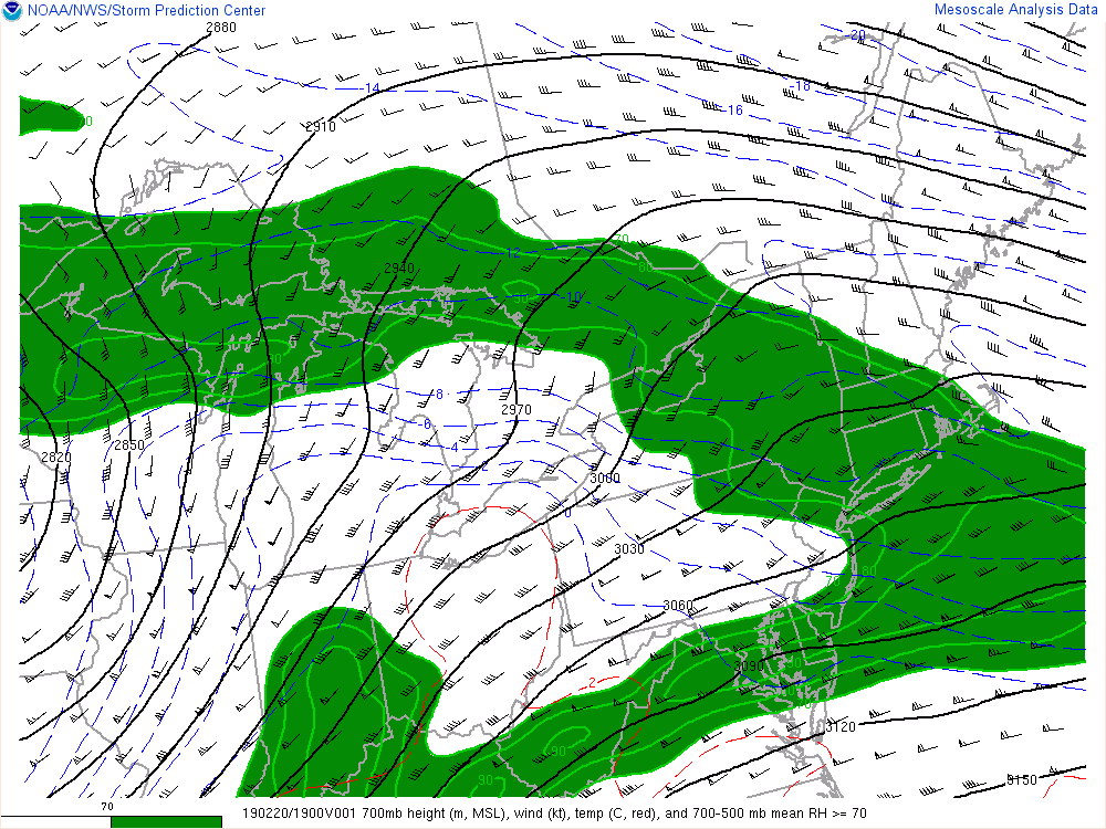
Sorry if already posted (hard to keep up), but The mesoscale, short-term models are showing significant freezing rain risks for much of the area. The HRRR and CMC-RDPS are both showing about 0.1" of freezing rain for the 95 corridor NE of Trenton (and NW of Philly) and are showing a lot more than that NW of there, i.e., up to 0.5", which would be horrendous if it verified. Nobody wants to see that, but folks should be aware of this risk. NAM is showing the freezing rain risk to be NW of 95, not along it, at least in NJ. Maps below.
![[IMG]](https://rutgers.forums.rivals.com/proxy.php?image=https://scontent-lga3-1.xx.fbcdn.net/v/t1.0-9/52100115_10215598451468401_5744184094548295680_o.jpg?_nc_cat=106%26_nc_ht=scontent-lga3-1.xx%26oh=6e24a910428dfed340cc1c71599e08e3%26oe=5CDD9772&hash=a511bd99496fd6fb653a1b3761499eac)
![[IMG]](https://rutgers.forums.rivals.com/proxy.php?image=https://maps3.pivotalweather.com/maps/models/rdps/2019021212/030/zr_acc.us_ne.png&hash=3ca25d5e8599f2c9c73928471b84cb10)
![[IMG]](https://rutgers.forums.rivals.com/proxy.php?image=https://scontent-lga3-1.xx.fbcdn.net/v/t1.0-9/52595776_10215598476149018_4840842207504105472_o.jpg?_nc_cat=103%26_nc_ht=scontent-lga3-1.xx%26oh=0caa7d5b19fd1663469ff24af8c20dc8%26oe=5CDF2600&hash=948007cc16a4dac8b7b8efa9a9c08aaf)
Yikes, given SI is still at 26°F, the icing potential seems pretty high

-
Temp is 26°F and Td is 23°F but snow has lightened significantly and every so often hear the pingers against the window.
-
Just now, nzucker said:
Ripping pretty hard in the Bronx.
Yeah that mixing line is fast approaching, it's pretty much right on top of EWR - SI - JFK
-
1 minute ago, SnowGoose69 said:
The main reason you may be sleeping more than anything is you’re likely in that hole where the echoes are lighter. The dual pole radar argues not too many places in this forum should be seeing sleet right now
Yep snow has lightened significantly on Staten Island and I just heard some pingers hitting the window. Hopefully that's not the last of the snow

-
Staten Island down to 26°F with a Td of 22°F. Looks like South Shore of SI will start mixing any moment according to dual pol radar.
-
1 minute ago, RU848789 said:
Absolutely pouring snow here now - just measured 1/2" of snow and it's 29F. Might actually make that 1" of snow I was hoping to get, although looks like sleet line isn't far away...
Hopefully that bodes well for me just across the Arthur Kill River - my temp is down to 27°F.
-
Staten Island 28°F, Td of 20°F. Steady light snow continues with better returns knocking on my doorstep. The dual pol indication of mixing seems to have lessened a bit. Should find out soon enough
Edit: Now down to 28 with Td of 21.
-
2 minutes ago, Ericjcrash said:
Per dual pol that might be sleet.
Light snow in midtown, of course the streets are wet here.
Yes I was just about to post an edit that it looks like bright banding.
Either way this is the most exciting thing for me to track since November, in terms of storm duration.
-
Staten Island 29°F with Td up to 18°F, very light snow falling for the past hour. Radar looks good to my southwest with 35-40 dBZ echoes approaching from SW heading toward Edison/Brunswicks
-
29°F on Staten Island with a Td of 16°F. Very light snowfall started in earnest just after 8AM.
-
It's a gorgeous 64°F at Staten Island's mesonet site
![[IMG]](https://rutgers.forums.rivals.com/proxy.php?image=https%3A%2F%2Fscontent-lga3-1.xx.fbcdn.net%2Fv%2Ft1.0-9%2F52100115_10215598451468401_5744184094548295680_o.jpg%3F_nc_cat%3D106%26_nc_ht%3Dscontent-lga3-1.xx%26oh%3D6e24a910428dfed340cc1c71599e08e3%26oe%3D5CDD9772&hash=a511bd99496fd6fb653a1b3761499eac)
![[IMG]](https://rutgers.forums.rivals.com/proxy.php?image=https%3A%2F%2Fmaps3.pivotalweather.com%2Fmaps%2Fmodels%2Frdps%2F2019021212%2F030%2Fzr_acc.us_ne.png&hash=3ca25d5e8599f2c9c73928471b84cb10)
![[IMG]](https://rutgers.forums.rivals.com/proxy.php?image=https%3A%2F%2Fscontent-lga3-1.xx.fbcdn.net%2Fv%2Ft1.0-9%2F52595776_10215598476149018_4840842207504105472_o.jpg%3F_nc_cat%3D103%26_nc_ht%3Dscontent-lga3-1.xx%26oh%3D0caa7d5b19fd1663469ff24af8c20dc8%26oe%3D5CDF2600&hash=948007cc16a4dac8b7b8efa9a9c08aaf)
OBS thread Feb 20-21, 2019
in New York City Metro
Posted
Flake size has decreased a bit on Staten Island once again but there is an area of more impressive returns just getting to Hunterdon & Mercer Counties