

hm8
-
Posts
4,467 -
Joined
-
Last visited
Content Type
Profiles
Blogs
Forums
American Weather
Media Demo
Store
Gallery
Posts posted by hm8
-
-
CIMSS satellite blog has a post on this:
-
Just took a look at Joplin on Google Maps...I'm not sure when the image was updated but you can still pretty clearly see a scar from the tornado across the southern side of the city...as well as zoom in and see just the blocks and blocks of devastation.
-
Wowsers!
This year has brought us some of the most incredible tornado footage I've ever seen. Wow.
-
I'm attending the University of Michigan next year, which has a Atmospheric, Oceanic, and Space Sciences program as part of their engineering school, which I think is interesting and might be helpful. I was talking to one of the professors a while back about it, and they started talking about how today a lot of the work in these fields requires some engineering experiences and knowledge that many graduates don't receive at other schools.
Right now I'm planning on double amjoring in Atmospheric Sceinces and Computer Sciences.
-
Obama visited the area today...
"I've never seen devastation like this," Obama said. "It's heartbreaking. -
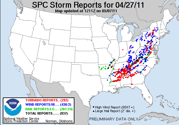
211 tornado reports
-
I dunno about having a tornado shelter. I just think people would be even less inclined to use it then they are already to take shelter in their basements.
-
ABC News just interrupted programming. President is about to speak about the outbreak.
Looks like he wants to use this a reprimands for the gov. response for Katrina...
He gave thanks to the firefighters and EMTs and police forecs on the scene (who obviously deserve it), but no mention of the NWS or SPC, who I think did a phenomenal job yesterday....but I guess that's to be expected...
-
Rosedale Courts images on a Facebook page
Hard to look at.
From Brent Adair's FB:
Just got information from a search team member in Pleasant Grove, AL....well built homes are no where to be found and people died in there basements. Some basements even damaged or "gone". This tornado may do things to the EF scale we never thought imaginable.
......no words
-
Kids in my computer class right now gathered around a computer watching some of the Tusculoosa footage...glad to see that they've at least heard of the event.
-
Just going off things we know for sure at this moment...
Trees debarked with only stumps of largest limbs remaining is EF3 expected damage, but only can be determined up to the highest (167 mph) at that scale. After that it becomes impossible to tell with any certainty how strong the winds were.
Likewise, we know transmission towers outside of Birmingham were taken down. Again this type of damage is consistent with EF3 damage, but once total loss occurs it is impossible to tell if winds were stronger.
As for other structures we've seen, there was that McDonalds in Tuscaloosa that was rendered down to just about nothing but the guts (could even argue completely gone). This damage is consistent with EF3 (or high EF4 if you consider it a total loss), and again higher wind speeds can't be stated with any certainty because the structure is expected to be gone at high EF4.
Easily EF3+, almost definitely EF4, and I personally need some context with what certain structures were before they were reduced to rubble before declaring EF5 for sure.
Whats the difference between EF4 and EF5 damage?
-
This event may very well end up being ranked in the top ten deadliest outbreaks in america of all time. All of the other events in this list are from 1974 or earlier, back when technology and warning lead times were barely a fraction of what they are today. I think that really shows the power of this event.
Birmingham, AL's disco this morning. I could not imagine having to write it.
"HOWEVER THE WEATHER NEVER ENDS AND WE MUST CONTINUE"
....amen
-
My jaw dropped...
-
I know that the got rid of the report filter....but to see N. AL colored in red is yet another thing that goes beyond words today

-
Anyone have a video of the skycam when the tornado was coming towards Tuscaloosa? Those images look terrifying,
-
Tuscaloosa video....wowo http://vimeo.com/22970879
That's....I've never seen anything like that before. The detail....the updrafts and vorticity is incredible. And all of those power flashes...
-
Just read through everything since this morning. Absolutely unreal. Today will go down in history.
-
I will be be occupied pretty much all day tomorrow and wont be able to get to a computer....but if anyone here could be so kind as to text me if it looks like anything noteworthy is happening in SEMI, I'd greatly appreciate it. I'm always on edge when I'm not updated on my weather....

PM me if you're willing
-
39 straight hours of 50 STI on the 15z SREF. Which is pretty ridiculous.
-
No change to the Day 2 outlook...
-
Dr. Greg Forbes Tue Apr 26. Severe thunderstorms and tornado outbreak in southeast MI, OH,
east and south IN, OH, west and central PA, west and central NY, west MD,
WV, southwest and north VA, DC, TN, KY, north GA, north half AL, north and
central MS, north LA, northeast TX, AR, south MO, southeast and south-central
KS, north and east OK.
Central/Western Medium-Long Range Discussion
in Central/Western States
Posted