

scootmandu
-
Posts
45 -
Joined
-
Last visited
Content Type
Profiles
Blogs
Forums
American Weather
Media Demo
Store
Gallery
Posts posted by scootmandu
-
-
Rain gauge here, in Fort Salonga, where we have finally moved into the axis of heaviest rain is up to 3.49, with the current rate at 1.70 an hour. If the overall rain area does not continue to slide east, it will be even worse. There is a solid line of red to our south and ssw. We have also had some loud peels of thunder in the past half hour, with more lightning seemingly approaching, based on the current radar.
-
 1
1
-
-
3 hours ago, NorthHillsWx said:
You’re not looking. Cape lookout, piney island, Beaufort, then pretty much every pier from hatteras north has seen 40+ mph gusts
I have been logging into Ambient weather, since I am one of the reporting stations and it is a great way to follow tropical systems through observing dozens of different stations in the regions being affected. t also see the reports on top current rain rate and wind gust from all the regions I select. Total rain, wind gusts and more in real time. Weather Underground also includes a barograph for their stations, and continuously recorded weather records for all of the reporting stations to follow barometric pressure, and to get the precise moments of storm passage over an area. Frisco, NC, in the Outer Banks, already had a gust to 55. It seems that virtually everyone on the outer banks has been getting gusts over 40.
-
1
-
-
It has been pouring since 11 AM, with rates as high as 2.72/hr. But we keep getting lulls and then periods of intense rain and thunder. Currently at 1.11 inches. All the local forecasts totally missed the boat. All official rainfall forecast, even now, say about 35 total for the entire day. Areas to our east and southeast have not even had rain, here was are getting storms generating just southwest of us that then build while over us. There really should be some sort of flash flood advisory for parts of Northwestern Suffolk. We are on the North Shore, at LI Sound, several miles west of Sunken Meadow.
-
Had thunderstorms within the last hour. Closest strike 4/10 of a mile to our west. We have picked up .30 so far. Since 3:30 PM, temp went up 10 degrees, as the wind switched from the east to the south. We topped out at 53.2 a short time ago, and now down from that slightly tp 51.3.
-
Crazy warm today. Already up to 67.5 in Fort Salonga. All the models seem way under on the forecasted temperatures.
-
Our current temperature is 9.9° with a windchill of -1.8°.
I looked at six different models on windy.com and for our location at 10 PM they ranged from 12° to 15°. We are significantly lower than that.
-
A total of .50 inches from the storm, here in Fort Salonga (NW Suffolk, at LI Sound). Our highest wind gust today was 38.7, while my neighbor had a gust to 43.
Currently 21.7 degrees, down from a high of 58.1
Lowest barometer was 28.98 at about 1:15 PM. That was the same time that the wind shifted from the south to the northwest and the temperature really started to plummet.
-
Precip is rapidly winding down. We logged .88 from this weather event so far, and earlier today had a peak wind gust of 27.3. The wind has completed its shift from ESE to N to NNW. Our barometer made it to 29.53 at 3 PM, before starting to rise a bit as the low passed south of Long Island.
-
The front came through roughly around 6, when the wind shifted from the South to West to North, fairly quickly. In the past half hour, we have dropped about 5 degrees. it is already at 50.7, which is at least a few degrees lower than all the models seemed to prog for our location at this time. I upgraded to Windy.com premium today (it's fairly inexpensive), and it is interesting comparing what all the 6 different models predict for our specific location. They all certainly got the exact timing of the wind shifting correct. We have a lot of trees, so it does affect our intensity here a bit. We did record over 27, while our neighbor peaked at 30. Our rain gauge measured 0.86, but he recorded a bit over an inch. We are in NW Suffolk, just off LI Sound, a few miles west of Sunken Meadow.
-
1
-
 1
1
-
-
11 hours ago, LibertyBell said:
I'll be so glad to see tropical season end. These systems should not be getting this far north anymore. I was sick all of last night with damn allergies and headaches. My nose looks like Rudolph's.
I wish we had weather control already and were able to steer all this stuff offshore.
Feel better!
-
1
-
-
Round 1 of the rain ended before midnight with 1.13 inches and wind out of the S and SSE gusting to 21.7. It looks like the wind is going to increase overnight. Probably more wind than rain with that new batch.
-
Rain has been consistently gaining in intensity over the last hour. Currently at .52" and the latest rate at .61"/hr. Temp/DP 67.1/66.7 and both rising. Top recent gust, SE at 12.5 nph.
-
An incredibly beautiful day. We peaked at 76.3, 90 minutes ago. Now 74.3. Winds have now shifted to the North, with a recent gust to 13.6. Dew point now steadily dropping, 10 degrees in the last 2-1/2 hours, right when the wind started shifting to a more northerly direction.
-
We hit exactly 75° today, a minute before noon. Second day in a row of at least 75.
-
1
-
-
10 hours ago, Rjay said:
Somehow, not one 80 on that map
We hit 75.7 degrees here at 1 PM. Amazing that we will have 2 more days in the 70s.
-
This week's storms gave us .92" of rain, with 5.68 for the month (after 5.99 in September). It is a pretty humid 66 degrees.
-
1
-
-
The storm gave us 2.25" of rain. 1.23" before midnight and 1.02" afterwards. Radar was showing a continuous line of rain training over our area after midnight. It was a relatively narrow band over Eastern Nassau and Western Suffolk. I know my totals are fairly accurate, because my neighbor has a reporting station and his rainfall total was even slightly higher than mine.
I decided to experiment yesterday with storm forecasting totals. I used 2 weather apps predictions, and combined them with 5 weather models forecasts, whose localised rainfall forecast I got by going to Windy.com, using their map to pinpoint my exact location, and then went through the 5 models they have posted, which will show you the predicted precipitation amount, specifically for your area. These were the 24-hour predicted totals as of 6 PM last night (before our rain began later that hour):
Predicted totals
ECMWF 1.63 GFS 1.02 HRRR 1.03 NAM 0.99 ICON 0.24
And from the apps:
Weather Underground 0.86 Dark Sky 1.73
They were all off by at least a half-inch, some much more than that.
-
1
-
-
3 hours ago, IrishRob17 said:
on RadarScope I checked the accumulated rainfall IMBY with the KDIX, KOKX, KENX and KBGM and none were even close to the 1.15" I recorded. As has been stated many time before, those radar accumulation maps are less than accurate for many, if not all, locations.
We got 2.25" here in NW Suffolk.. The radar accumulation totals were way off.
-
1
-
-
Moderate to heavy rain for the last hour has been fairly continuous. Total is now up to 1.36" in Fort Salonga in NW Suffolk (adjacent to LI Sound). Looks like it might let up soon, but hard to say when it will end. Looked at the rainfall totals on RadarScope and radar is showing significantly less than what we have gotten.
-
2
-
-
On 10/6/2022 at 2:03 AM, LibertyBell said:
Do these work on a PC or do you need to have a phone to be able to use them?
I use apps on both. But I have 8 different forecasting apps on my iPhone (plus radar and other weather apps). Weather Underground has their hourly forecasts on PC, and I assume some others do as well. Dark Sky is going to be gone by the end of the year, but that app was probably the best for when precip was expected to arrive and how long it will last. I just discovered Windy.com on my PC, which shows very specific forecasts, which you can tailor to your exact location, for rain, wind, precip, etc...from 5 different weather models, with some going out 7 days. Interesting to compare different forecasts temp, precip totals for different time periods, wind flow, specific, forecasted wind speed and direction, etc...
-
1
-
1
-
-
A short period of moderate rain, between 3:45 and 4:15 AM (highest rate was .19/hr) dropped .08 inches.
Our total for October is now 2.39, after 5.99 in September.
Currently 56/42, down from 74/56 same time yesterday.
-
1 hour ago, Tatamy said:
Are you able to get a news media app that will tell you that it will rain or snow or thunder in X minutes and that it will last for () minutes? I get that from the NBC station in Philadelphia and it is a great feature.
Dark Sky usually specifically does that and Weather Underground shows hour by hour totals (as do a few others). When I first saw the storms on radar it seemed pretty clear they were coming our way an hour before. But the apps I was looking at showed no imminent rain from them. Thanks for the info, though.
-
Was about to post from my PC when a bolt of nearby lightning temporarily knocked out power. Safer to post from my phone. I had been watching the lightning approach for over an hour. Still more storms to our east, heading west. The weather bug app lightning map feature showed a large cluster of lightning strikes clustered around us. 1 was virtually on top of us. Yet none of the weather apps (Dark Sky, Weather Underground, etc..) were predicting even that rain was imminent. The biggest strikes here were about 10 minutes before this radar screenshot. Still hear rumbles of thunder.
Total so far: 0.59 for the day, 1.66 total. Current rate 0.17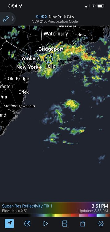
-
1
-
-
Between last night and today, we picked up .96." Hoping for another half inch to an inch, when all is said and done. Temp at high for the day at 55.8, with a DP of 54.7. The winds have slowly started to calm down a bit.

Another big Sept rain event between roughly midnight Friday morning and midnight Sunday morning (bulk 9/29-30/2023)
in New York City Metro
Posted
Up to 4.19" and our rate has finally dropped under an inch, it is now at 0.95/hr. It had been significantly higher, although never more than 1.75/hr,which was a bit more than 30 minutes ago.