
Central Illinois
-
Posts
1,206 -
Joined
-
Last visited
Content Type
Profiles
Blogs
Forums
American Weather
Media Demo
Store
Gallery
Posts posted by Central Illinois
-
-
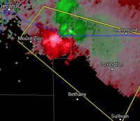
58 minutes ago, Chambana said:
Moderate bands of snow just keep coming like a conveyor belt. Legit snowstorm now, I am 110.% satisfied. Winds are absolutely howling right now, steady gusts at 40mph winds.
little over 12" here on the southeast side of decatur and still have moderate snow might get another inch or so before its done

-
 2
2
-
-
Just now, StormChaser4Life said:
Where did you see that? My grids still showing in the 30's
its in the updated winter storm warning as of 11:45am
-
 1
1
-
-
ILX calling for wind gusts to 40mph now
-
1
-
-
URGENT - WINTER WEATHER MESSAGE
National Weather Service Lincoln IL
310 AM CST Fri Jan 18 2019

...WINTER STORM TO IMPACT CENTRAL ILLINOIS TONIGHT INTO SATURDAY
EVENING...

ILZ044>046-053-182200-
/O.UPG.KILX.WS.A.0002.190119T0000Z-190120T0000Z/
/O.NEW.KILX.WS.W.0002.190119T0600Z-190120T0600Z/
Piatt-Champaign-Vermilion-Macon-
Including the cities of Monticello, Champaign, Urbana, Danville,
and Decatur
310 AM CST Fri Jan 18 2019

...WINTER STORM WARNING IN EFFECT FROM MIDNIGHT TONIGHT TO
MIDNIGHT CST SATURDAY NIGHT...

* WHAT...Heavy snowfall expected. Total snow accumulations of 4 to
  6 inches expected. Winds gusting as high as 35 mph.

* WHERE...Piatt, Champaign, Vermilion and Macon Counties.

* WHEN...From midnight tonight to midnight CST Saturday night.

* ADDITIONAL DETAILS...Plan on slippery road conditions. Areas
  of blowing snow could significantly reduce visibility.
-
Just now, StormChaser4Life said:
I just saw that
 I'm not sure I still believe a screw hole to be that large with this but concerning it shows one similar to euro. Guess only time can tell
hopefully for your sake it isn't nearly as big
-
1 hour ago, StormChaser4Life said:
The screw hole on euro is laughable. I mean I can see a lull between the fgen band and the heavier band of deformation zone but one that large no. Just comical it has the lowest qpf bullseyed over me
FWIW 18z NAM coming in with a similar screw hole across Northern ILX
-
3 minutes ago, Chicago Storm said:
What a run...


.Wow thats a fantasy type run for this area
-
1 hour ago, hlcater said:
Like normal, this isn't my map. So no, I cant give you the amounts farther east :(.
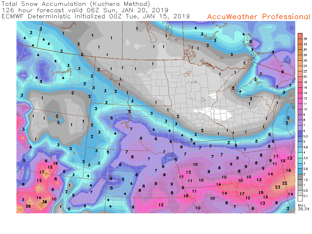
That would break the all time record of 19" here
-
1
-
-
Finished with 10.1” here what a great storm!
Sent from my iPhone Xs using Tapatalk-
2
-
-
I know its early but the Euro is putting out crazy numbers for next weekends storm...the one thing to take away is most models are signaling for something significant
-
10 minutes ago, Chambana said:
Congrats. Dry air has been winning the battle here the last 4 hours. You must be in Mt Zion? Heavy band going through right now.
Yeah i'm two miles south huge flakes right now...hopefully you can add on before its totally done the band south of you looks pretty good.
-
heaviest snow coming down currently just over 9"
-
really starting to pick up here might be able to get another 1-2" before its over
-
19 minutes ago, homedis said:
To me, it looks like Champaign-Urbana really missed out on a lot of the snow. Just really bad luck, I guess.
Yeah areas west of I-57 have done the best widespread 7-12" totals with less east of 57
-
1
-
-
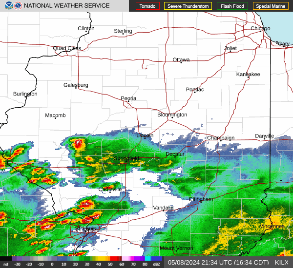
Looks like some heavier returns are starting to head NE out of St Louis
-
Just over 8" here ILX calling for another 3-5" before its done
-
1
-
-
7.5" here starting to pick up in intensity again
-
22 minutes ago, Chicago Storm said:
You worry too much. Enjoy the 6"+
Do you think ILX numbers are pretty realistic? 8-12 south of 74 and 6-9" north of 74
-
7 minutes ago, janetjanet998 said:
ILX bumped up totals tad for PIA in the latest update 6-9 vs 5-8
They also bumped up totals south of I-74 now calling for 8-12" it was 7-9"
-
Snow is really coming down here started about 10mins ago
-
26 minutes ago, StormChaser4Life said:
Yea that's my concern. They aren't lining up well. So may be dealing with pixie dust. But should have periods of better flake size. Hopefully. Lol
ILX just extended the WSW includes Bloomington/Peoria areas now! they upped the totals 5-8" now
-
1
-
-
Indy went WSW 5-7"
ILX went WSW 7-9"
-
6-8" along I-74 south of that 8-12" in IL with 12-16" near STL
-
1
-
-
4 minutes ago, StormChaser4Life said:
What is its track record like with past winter storms?
I think its been pretty decent
-
1
-
Feb 1-3rd GHD III Part 3
in Lakes/Ohio Valley
Posted
updated snowfall reports from ILX